Backcountry enthusiasts find Albert Pike Recreation Area serves as a gateway to wilderness camping along the Little Missouri River, though the established campground remains closed following a devastating 2010 flood. The Forest Service maintains day-use facilities with picnic tables, restrooms, and drinking water, but overnight camping requires hiking to dispersed sites along nearby trails.
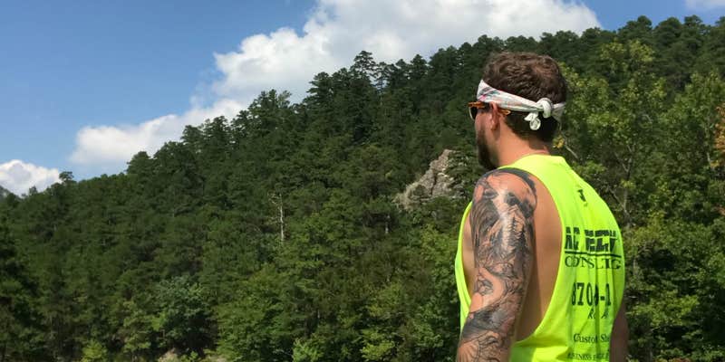
The Eagle Rock Loop trailhead provides access to developed backcountry campsites scattered throughout the 28-30 mile circuit. Multiple river crossings punctuate the route, with clear swimming holes carved into rock formations upstream from the recreation area. Katie K. notes "the water is perfect, the woods lush, and lots of wildlife" in the backcountry areas. Forest Road 106 leads 2.1 miles uphill to the Winding Stairs trailhead, where additional primitive camping opportunities exist along creek drainages.
Flash flooding poses a serious risk throughout this drainage system. Weather awareness becomes critical when selecting camping dates, as the area's history demonstrates the deadly potential of sudden water rises. The recreation area attracts heavy weekend crowds during peak seasons, making early arrival advisable for day visitors.
Pet-friendly camping near Ouachita National Forest includes several developed options within a few miles for campers preferring established sites with amenities. Albert Pike works best for experienced backpackers comfortable with Leave No Trace principles and weather-dependent trip planning.
Description
Nestled in the forested splendor of the rugged Ouachita Mountains, this recreation area is located in the southern portion of the national forest. Visitors are invited to hike the nature trail or experience the excitement of a canoe trip on the Little Missouri River.
Day use/swimming only.
RV Road Trip Guides


Map & DirectionsAlbert Pike Recreation Area is located in Arkansas near Langley
Directions
From Hot Springs take Highway 70 west 36 miles through Glenwood to Salem. Turn west on Highway 84 and go 13 miles to Langley. At Langley turn north on Highway 369 and go 6 miles to the recreation area.
Coordinates
34.37476452 N
93.87765655 W
Connectivity
 T-MobileNo Coverage
- VerizonNo Coverage
- AT&TNo Coverage
Connectivity
- T-MobileNo Coverage
- VerizonNo Coverage
- AT&TNo Coverage
Access
- Walk-InPark in a lot, walk to your site.
- Hike-InBackcountry sites.
Site Types
- Tent Sites
- Standard (Tent/RV)
- Group
Features
For Campers
- Trash
- Picnic Table
- Drinking Water
- Toilets
- Alcohol
- Pets
- Fires
For Vehicles
- Pull-Through Sites
FREE established camping
Enjoy camping on government land. Limited or no services at this camping area.
PERMIT might be REQUIRED
We curate permit requirements across the US for our PRO members. Try PRO to see if Albert Pike Recreation Area needs a permit.
Drive Time
- 1 hr 11 min from Hot Springs, AR
- 1 hr 40 min from Texarkana, TX
- 1 hr 57 min from Little Rock, AR
- 2 hrs 37 min from Fort Smith, AR


