Clints Well Campground is located near Happy Jack in the Coconino National Forest. The area features forested terrain with pine trees and is situated at an elevation that brings cooler temperatures, ranging from 30°F in winter to 80°F in summer. Nearby attractions include the scenic Mogollon Rim and the historic town of Sedona, offering opportunities for hiking and exploration.
Description
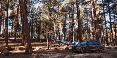
Clints Well Campground is located near a junction of two major roads which provide access to northern Arizona's National Forest lands. As such it is close to several features of recreational interest. A short drive from the campground is the scenic Mogollon Rim, the two thousand foot drop-off that marks the southern limit of the Colorado Plateau. Also within easy driving distance are a number of forest lakes known for their excellent fishing. A small community which is springing up at the crossroads provides easy access to services such as a gas station/country store and a restaurant. Campsites at Clints Well are tucked away in a stand of tall, old growth ponderosas a short distance off the highway. Since access is so convenient, the area is open year-round although after winter storms the campground and surrounding roads may become impassable and are occasionally closed. Group Campouts and Events: This campground does not have facilities for large groups or group activities. If one campsite cannot accommodate your group (eight people and two cars per site), please call the Mogollon Rim Ranger District at 928-477-2255 to plan your group camp-out at Elks, Moqui, or Long Valley group campgrounds.
Reservation Info
Tents, motor homes and trailers under 22' are permitted No utility hookups. No drinking water available Pets must always be restrained or on a leash. No horses allowed in the campground. Licensed off-road vehicles may be used only for entering or leaving campsite. 14 day stay limit.
RV Road Trip Guides
Location
Public CampgroundClints Well Campground is located in Arizona
Directions
Location : 55 miles southeast of Flagstaff. GPS (Map): 34°33'18.9"N 111°18'56.3"W Access : Drive 55 Miles south of Flagstaff on Forest Highway 3 (Lake Mary Road). The campground is just north of the Clints Well intersection.
Coordinates
34.5550477 N
111.31555282 W
Connectivity
- T-Mobile5GExcellent CoverageVerified by 9 usersLast on 2/14/26
- Verizon5GExcellent CoverageVerified by 10 usersLast on 2/14/26
- AT&TLTESome CoverageVerified by 7 usersLast on 2/14/26
Connectivity
- T-Mobile5GExcellent CoverageVerified by 9 usersLast on 2/14/26
- Verizon5GExcellent CoverageVerified by 10 usersLast on 2/14/26
- AT&TLTESome CoverageVerified by 7 usersLast on 2/14/26
Access
- Drive-InPark next to your site
- Walk-InPark in a lot, walk to your site.
Site Types
- Tent Sites
- RV Sites
- Standard (Tent/RV)
Features
For Campers
- ADA Access
- Picnic Table
- Phone Service
- Toilets
- Alcohol
- Pets
- Fires
For Vehicles
- 30 Amp Hookups
- Big Rig Friendly
Drive Time
- 59 min from Flagstaff, AZ
- 1 hr 13 min from Prescott Valley, AZ
- 1 hr 48 min from Phoenix, AZ
- 3 hrs 29 min from Tucson, AZ


