Managed by the USDA Forest Service along SR 542 in Maple Falls, Washington, this established campground sits within the Mt. Baker-Snoqualmie National Forest amid forested and open terrain with access to both river and lake environments. No pets are permitted. Review data is limited, so campers should contact the Forest Service directly for current site conditions, amenity details, and reservation requirements before heading out. Mount Baker Highway (WA 542) Dispersed is a nearby alternative for those who prefer a less structured stay along the same corridor.
Description
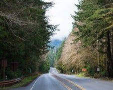
Starting at the northern boundaries of the forest, take a drive on the Mt. Baker Scenic Byway (State Route 542). This paved road starts at the Interstate 5 interchange in Bellingham, Wash., winds along the scenic North Fork Nooksack River, and climbs to an elevation of 5,140 feet to its well-named destination, Artist Point. This area is legendary for its spectacular views of Mt. Baker and Mt. Shuksan. Stop by the Glacier Public Service Center just east of Glacier at milepost 34 to learn about current forest road and trail conditions. Mt. Baker - A State Scenic Highway and National Forest Scenic Byway State Route 542 is a Washington State Scenic Highway and a National Forest Scenic Byway. The forest byway begins just east of the town of Glacier as the route enters the national forest, leading travelers to historic Heather Meadows, home of the Mt. Baker Ski Area. Forest roads lead off the main highway into the heart of the national forest with trails accessing the Mt. Baker Wilderness and North Cascades National Park backcountry.. Four Seasons of Recreation During summer months, Mt. Baker's 10,781 foot snow-covered peak rises above the landscape. On a clear day, several vantage points offer spectacular views of neighboring Mt. Shuksan and surrounding slopes of the Cascade Mountain range. Hikers can head out on more than 200 miles of trails and campers can enjoy long evenings in rustic settings. The fall months bring cooler temperatures and lower snow levels, limiting hiking access to the high country. Several side roads are groomed, turning them into a winter playland for snowmobiles and cross-country skiers. During winter months the Mt. Baker Ski Area operates in Heather Meadows at the end of the byway. . Heather Meadows Heather and huckleberry meadows dotting the Heather Meadows landscape near the eastern end of the Mount Baker Scenic Byway, (State Route 542). Glistening lakes nestle between knolls. Ridges bristle with 900-year-old mountain hemlock. Lava flows from Mount Baker have resisted glacial carving and columns of basalt stand like black anvils against the sky. During the summer months enjoy a picnic, stroll the trails and stop by the Heather Meadows Visitor Center for a historical perspective of the area’s rich heritage.. Recreation Area Map National Scenic Byway
RV Road Trip Guides

Map & DirectionsMt. Baker Highway (SR 542) is located in Washington near Maple Falls
Coordinates
48.89175372 N
121.95946527 W
Connectivity
 T-MobileNo Coverage
- VerizonNo Coverage
 AT&TLTESome Coverage
Connectivity
- T-MobileNo Coverage
- VerizonNo Coverage
- AT&TLTESome Coverage
Access
Site Types
- Tent Sites
Features
Drive Time
- 41 min from Bellingham, WA
- 1 hr 3 min from Mount Vernon, WA
- 1 hr 56 min from Seattle, WA
- 2 hrs 54 min from Bremerton, WA
