Lockett Meadow Campground operates seasonally from May through October with 17 sites available on a first-come, first-served basis for $18 per night. Located within Coconino National Forest at high elevation, the campground requires navigating a rough access road that challenges low-clearance vehicles. Caitlyn K. learned this lesson when she "cracked my oil pan pulling into the spot," though the road remains passable for most vehicles with adequate ground clearance.
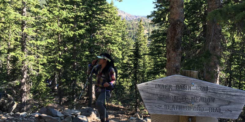
The campground sits among aspen groves that draw crowds during fall color season, typically the first weeks of October. Reviewers consistently note the spacing between sites provides privacy, though wind can be significant at night. Several mention the meadow itself as modest in size, while the surrounding forest offers immediate access to hiking trails including the popular Inner Basin Trail and routes toward Humphreys Peak, Arizona's highest point.
Sites fill quickly due to limited capacity, with Heather S. noting they "get full fast" especially during peak autumn foliage. The campground provides vault toilets and allows alcohol, though pets are prohibited. Cell service is available, particularly from higher points like Sugar Loaf. Wildlife encounters include tarantulas and mountain lion sightings reported by campers.
Access challenges extend beyond the rough road - the campground closes entirely when snow blocks the route, typically lasting from late fall through early spring. Campers unable to secure paid sites can find dispersed camping options at lower elevations. For those exploring the broader region, camping near Coconino National Forest includes additional forest service options, while campsites near Flagstaff provide alternatives with easier access. The campground works best for campers with suitable vehicles who arrive early and come prepared for mountain weather conditions.
Description
NOTE: This dirt road is closed in early spring and late fall due to snow
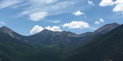
This primitive campground offers a scenic view of the San Francisco Peaks and dry camping in the cool aspen trees that surround Lockett Meadow. This is a terrific campground for those who cherish a real mountain camping experience and love to hike wilderness trails. You may catch a glimpse of the natural residents, porcupine or elk or thrill to the song of a hermit thrush that sings his best here. Even black bear have been known to stroll right through groups of picnickers without as much as a glance at their lunches.The San Francisco Peaks are actually the remains of an extinct volcano, which mllions of years ago shattered and reshaped these great peaks, forming four of the highest individual peaks in Arizona and is home to the only region of tundra in Arizona. Inside the now quiet caldera a lush alpine environment has blurred evidence of that cataclysmic event.The Inner Basin Trail that leads into the heart of the ancient volcano begins in beautiful Lockett Meadow. Starting at this island of emerald, which is ringed with quaking aspen stands and majestic high peaks, it leads into the mountains now quiet Inner Basin. The spring and summer wild flowers add a sprinkling of blue, red and yellow to the peaceful scene. While fall turns the extensive stands of aspen, which cover the steep slopes of the caldera, to solid gold, Winter avalanche tracks streak down the talus slopes exposing remnants of old lava flows which bear witness to the mountains turbulent heritage.__Hover mouse over photo to display slideshow controls. View album on Flicker
Reservation Info
No reservations. This campground is on a first-come, first-served basis.
Warning 1 Alert is In Effect
There is 1 alert for this campground. Camp safely!
Warning 1 Alert is In Effect
There is 1 alert for this campground. Camp safely!
Air Quality at this campground may currently be unhealthy for sensitive groups.
RV Road Trip Guides


Map & DirectionsLockett Meadow Campground is located in Arizona near Flagstaff
Directions
Location: 15 north of Flagstaff in the heart of the San Francisco Peaks.Directions: Drive northeast of Flagstaff on US Highway 89 for 12.5 miles. Turn left on Forest Road 552, directly across from the Sunset Crater National Monument turnoff. Follow FR 552 for approximately one mile. Turn right at the Lockett Meadow sign and continue to the campground. This dirt road is closed in early spring and late fall due to snow.This road is not recommended for RVs/trailers due to the very steep, narrow (single lane), and rough road.GPS (Map): 35\_\_21'33.3\"N 111 37'09.7\"W Click map thumbnail for larger view.
Coordinates
35.3586 N
111.6208 W
Connectivity
 T-Mobile5GGood Coverage
 VerizonNo Coverage
- AT&TNo Coverage
Connectivity
- T-Mobile5GGood Coverage
- VerizonNo Coverage
- AT&TNo Coverage
Access
- Drive-InPark next to your site
- Walk-InPark in a lot, walk to your site.
- Hike-InBackcountry sites.
Site Types
- Tent Sites
- Standard (Tent/RV)
- Group
Features
For Campers
- Phone Service
- Toilets
- Alcohol
Drive Time
- 28 min from Flagstaff, AZ
- 1 hr 41 min from Prescott Valley, AZ
- 2 hrs 16 min from Phoenix, AZ
- 4 hrs 6 min from St. George, UT


