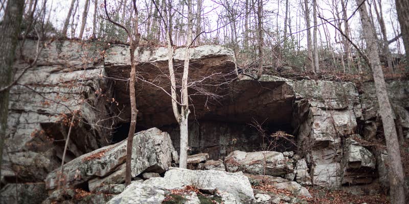
Camper submitted image from Lockhart's Arch Shelter - on the Cumberland Trail - 1

View Photos

Camper submitted image from Lockhart's Arch Shelter - on the Cumberland Trail - 2
Nature
Camper submitted image from Lockhart's Arch Shelter - on the Cumberland Trail - 3
Buildings
Camper submitted image from Lockhart's Arch Shelter - on the Cumberland Trail - 4
Camping
Camper submitted image from Lockhart's Arch Shelter - on the Cumberland Trail - 5
Facilities
Unlock Planning Tools in App
pro

Free Camping Collection

Established Camping

Lockhart's Arch Shelter - on the Cumberland Trail

Do you own or manage this property?

Claim Your Listing
CAMPER SUMMARY PRESENTED BYFord

Lockhart's Arch Shelter near Signal Mountain, TN, is surrounded by forested terrain with rocky outcrops. Temperatures range from 30°F in winter to 85°F in summer. Nearby attractions include the Cumberland Trail and Signal Point, offering hiking opportunities and scenic views.

Suggest an Edit

Location

Lockhart's Arch Shelter - on the Cumberland Trail is located in Tennessee

Detail location of campground

Coordinates

35.12790047 N
85.3693004 W

Open in Google Maps

Connectivity

Presented byT-Mobile SatelliteT-Mobile is introducing T-Satellite to extend coverage in the outdoorsLearn More
  • signal strength bars
    T-Mobile5G
    Good Coverage
  • signal strength bars
    VerizonLTE
    Some Coverage
  • signal strength bars
    AT&T5G
    Good Coverage
    Verified by 2 users

Detours Nearby

LOCAL FAVORITES PRESENTED BYToyota Trucks
Fireside Camp + Lodge

Fireside Camp + Lodge

39 min away

Camp Chet

Camp Chet

50 min away

Drive Time

Presented byToyota Trucks

Connectivity

Presented byT-Mobile SatelliteT-Mobile is introducing T-Satellite to extend coverage in the outdoorsLearn More
  • signal strength bars
    T-Mobile5G
    Good Coverage
  • signal strength bars
    VerizonLTE
    Some Coverage
  • signal strength bars
    AT&T5G
    Good Coverage
    Verified by 2 users

Access

  • Hike-In
    Backcountry sites.

Site Types

  • Tent Sites

Features

For Campers

  • Reservable
  • Alcohol
  • Pets
  • Fires

FREE established camping

Enjoy camping on government land. Limited or no services at this camping area.

Contact

General Info

Reservations


2025 Detourist Giveaway

Presented byToyota Trucks

Review Campgrounds. Win Prizes.

Enter to Win

Reviews

Add Review

5 Stars

4 Stars

3 Stars

2 Stars

1 Star

0%
100%
0%
0%
0%

4.0

out of 5

1 Review

Reviewed Apr. 18, 2019

Small and cozy backcountry camping

The southernmost campsite on the Cumberland Trail, the Lockhart's Arch shelter is only 1.8 miles from the southern Terminus of the CT, at Signal Point. The hike in to this shelter is moderate, passing beautiful views at Julia Falls Overlook, and a cool suspension bridge as it crosses Middle Creek.

The shelter is after climbing out of Middle Creek Gorge, and follows a spur trail off the CT that is not marked, making this shelter somewhat difficult to find in the dark.

The shelter is very small, covered on three sides, with enough room to fit 2-3 adults. It has a small shelf to store gear, and a few nails to hang bags on, but does not have anything hanging from the ceiling to help protect your food from mice, so take appropriate food storage measures. The space the shelter occupies is small, but has enough room for one or two small backpacking tents if you prefer your tent to the shelter, though the ground is not very level so be aware of your tent's footprint. There is a well-established fire ring. The closest guaranteed water source is Middle Creek, so be sure to fill water bottles and filter when you cross, although if there has been a lot of recent rain there is a chance of small seasonal streams closer to the shelter.

This shelter is an excellent place to stay if you are looking for a place near Chattanooga to hike in to, if you want to take advantage of the incredible sunsets at the nearby Edwards' Point and have a place to stay without hiking out in the dark, or as a starting point on the southern stretch of the Cumberland Trail. Be aware however that the closest trailhead is at Signal Point, and overnight parking is not allowed, so plan on having a ride! A backcountry permit is also required, though is free and can be obtained through the Cumberland Trail website.

Month of VisitOctober
  • Review photo of Lockhart's Arch Shelter - on the Cumberland Trail by Stephanie J., April 18, 2019
  • Review photo of Lockhart's Arch Shelter - on the Cumberland Trail by Stephanie J., April 18, 2019
  • Review photo of Lockhart's Arch Shelter - on the Cumberland Trail by Stephanie J., April 18, 2019
  • (9) View All

Frequently Asked Questions

Where is Lockhart Gorge located in Tennessee?

Lockhart Gorge is located in southeastern Tennessee near Signal Point. The area is part of the Cumberland Trail system, with the Lockhart's Arch shelter situated 1.8 miles from the southern terminus of the Cumberland Trail at Signal Point. The gorge features scenic views including Julia Falls Overlook as you travel along the trail.

Is camping allowed at Lockhart Gorge in Tennessee?

Yes, camping is allowed at Lockhart Gorge via the Lockhart's Arch shelter. This is the southernmost designated campsite on the Cumberland Trail and is located 1.8 miles from the trail's southern terminus at Signal Point. The site features a shelter structure for overnight stays. Hikers planning to camp should be prepared for a moderate hike in with their gear. For current regulations and potential permit requirements, check with Cumberland Trail State Park officials before your trip.

What hiking trails are available at Lockhart Gorge in Tennessee?

The main trail at Lockhart Gorge is the Cumberland Trail, which passes through the area. Hikers can access the trail from the southern terminus at Signal Point. The 1.8-mile section to Lockhart's Arch shelter is rated as moderate difficulty and features notable landmarks including Julia Falls Overlook and a suspension bridge that crosses Middle Creek. This section offers beautiful scenic views throughout the hike.