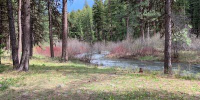
Along the Middle Fork of the John Day River, this US Forest Service campground sits within large pine trees on reclaimed mining land. The eight-dollar fee covers spacious sites with water and sewer hookups, making it big rig friendly. Two vault toilets serve the small campground, though campers must bring their own water and pack out garbage.
Sites spread far apart from each other, and despite the adjacent paved road, reviewers report minimal traffic. River access requires navigating through shrubs and small trees, but dogs can swim in the water. The area showcases ongoing restoration efforts by the Warm Spring Tribe across 2,000 acres of previously dredged land. Campers exploring the region can find camping near Prairie City for additional options.
Description
Overview
This small campground along the Scenic Middle Fork of the John Day River set back amongst beautiful ponderosa pine trees is a great spot for fishing and viewing spawning steelhead in the fall. The campground is a good starting point for hunters, hikers and those wishing to see beautiful scenery, wildlife and wildflowers. The campground sets just off of the county road allowing for easy access to all variety of vehicles and bicycles.
Recreation
This campground offers excellent fishing access along the Middle Fork John Day River, along with a unique chance to view spawning steelhead during the fall months. Visitors can enjoy nearby hikes and wildlife and wildflower viewing. It also provides a great base camp for hunters.
Facilities
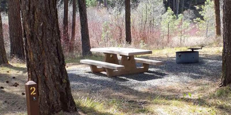
Each campsite has a picnic table, fire ring and parking for camp trailers. Accessible vault toilets are conveniently located in the middle of the campground.
Natural Features
Middle Fork John Day River
Contact Info
For facility specific information, please call (541) 575-3000.
Nearby Attractions
Davis Creek TrailVinegar Hill Indian Rock Scenic AreaTempest Mine TrailSunrise Butte TrailPrincess TrailBates State ParkAustin House
Warning 1 Alert is In Effect
There is 1 alert for this campground. Camp safely!
Warning 1 Alert is In Effect
There is 1 alert for this campground. Camp safely!
All campsites are first come, first serve. No reservations required.
RV Road Trip Guides


Map & DirectionsMiddle Fork is located in Oregon near Prairie City
Directions
From the town of Prairie City, OR, travel east on US Highway 26 approximately 11 miles to the junction of US Highway 7, follow US Highway 7 for approximately 1 mile to the junction with County Road 20, junction will be on the left. Follow County Road 20 for approximately 5 miles, the campground will be on the left.
Coordinates
44.630064 N
118.605606 W
Connectivity
 T-MobileNo Coverage
- VerizonNo Coverage
- AT&TNo Coverage
Connectivity
- T-MobileNo Coverage
- VerizonNo Coverage
- AT&TNo Coverage
Access
- Drive-InPark next to your site
Site Types
- Tent Sites
- RV Sites
- Standard (Tent/RV)
- Group
- Tent Cabin
Features
For Campers
- Alcohol
- Pets
For Vehicles
- Sewer Hookups
- Water Hookups
- Big Rig Friendly
Drive Time
- 2 hrs 48 min from Boise, ID
- 3 hrs 22 min from Walla Walla, WA
- 3 hrs 29 min from Bend, OR
- 3 hrs 37 min from Kennewick, WA


