Water enthusiasts find direct access to both creek and river at Kirkwood Ranch, a US Forest Service campground situated within the Nezperce National Forest. The established campground operates under a no-pets policy, making it distinct from many forest service locations. Campers can explore camping spots around Nezperce National Forest for additional forest-based options in the region. The creek and river proximity provides opportunities for fishing and water-based recreation. Book early during peak season as forest service campgrounds fill quickly.
Description
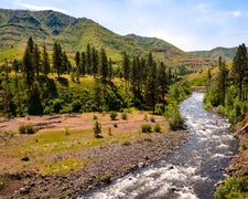
The__Kirkwood Historic Ranch is an area rich in river history from early Native American occupation to pioneer ranching life. This very popular site__is accessible by boat via the Snake River, or by hiking the Snake River National Recreation Trail which begins at Pittsburg Landing, approximately 6 miles down river. The historic ranch offers a taste of canyon life in the 1930s with the original ranch house, bunk houses and other out-buildings. As in the past, the cool green lawn and nearby stream offer summer time visitors a welcome rest.Visitors are welcome to stop at the museum (Temporarily Closed) and learn about ranching life in the canyon. Displays in the log bunkhouse also contain prehistoric artifacts and interpret early Native American occupation in the canyon. A short 3/4 mile hike up Kirkwood Creek takes visitors to the Carter Mansion. It is a vertical log house built in 1920 by Dick Carter, a canyon resident who made his money manufacturing and selling moonshine during the Prohibition era.
RV Road Trip Guides

Map & DirectionsKirkwood Ranch is located in Oregon near Riggins
Directions
Although access is primarily by boat on the Snake River, you can also access it on the Snake River trails.From White Bird, Idaho head south on Highway 95 for about 0.5 miles to Old Highway 95 at mile marker 222 (sign indicates Pittsburg Landing and Hammer Creek Recreation Area); Turn right on Old Hihgway 95 and go about 1 mile to the bridge crossing the Salmon River; Turn left and cross the bridge; Immediately after the bridge turn left on the Deer Creek Road (also known as Forest Road 493); Travel on the Deer Creek Road for 17 miles to Forest Road 493A; Turn left on Forest Road 493A and go 1.6 miles to end the road to the Upper Pittsburg Picnic Area (or stop and park in the large Snake River Trailhead parking area); the Snake River begins from the end of the road and goes about 6 miles to Kirkwood Ranch.From Riggins, Idaho head north on Highway 95 for about 27 miles to Old Highway 95 at mile marker 222 (sign indicates Pittsburg Landing and Hammer Creek Recreation Site); Turn left on Old Highway 95 and go about 1 mile to the bridge crossing the Salmon River; Turn left and cross the bridge; Immediately after the bridge turn left on the Deer Creek Road (also known as Forest Road 493); Travel on the Deer Creek Road for 17 miles to Forest Road 493A; Turn left on Forest Road 493A and go 1.6 miles to end the road to the Upper Pittsburg Picnic Area (or stop and park in the large Snake River Trailhead parking area); the Snake River begins from the end of the road and goes about 6 miles to Kirkwood Ranch.Note the Deer Creek Road and Forest Road 493 is a steep, narrow winding paved gravel road.
Coordinates
45.56779 N
116.497783 W
Connectivity
 T-MobileNo Coverage
- VerizonNo Coverage
- AT&TNo Coverage
Connectivity
- T-MobileNo Coverage
- VerizonNo Coverage
- AT&TNo Coverage
Access
Site Types
- Tent Sites
Features
Drive Time
- 2 hrs 36 min from Lewiston, ID
- 4 hrs 2 min from Boise, ID
- 4 hrs 23 min from Walla Walla, WA
- 4 hrs 55 min from Kennewick, WA

