SUMMARY PRESENTED BY
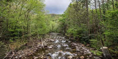
Black Mountain / South Toe River Area is located near the Blue Ridge Mountains in North Carolina. The terrain features forested areas and riverbanks, providing a natural setting for camping. Nearby attractions include the Blue Ridge Parkway and Mount Mitchell State Park, with temperatures ranging from 30°F in winter to 85°F in summer.
Description
The South Toe River area is on the Appalachian Ranger District near Burnsville, NC. This area includes the Black Mountains, the Blue Ridge, and the headwaters of the South Toe River. The Black Mountains, capped with a forest of red spruce and Fraser fir, are named for the resulting dark color. Along the South Toe River, you can camp, picnic, fish, swim, tube, bike, and horseback ride.
RV Road Trip Guides


Map & DirectionsBlack Mountain / South Toe River Area is located in North Carolina near Pisgah Forest
Coordinates
35.28329514 N
82.72183667 W
Connectivity
 T-Mobile5GGood CoverageVerified by 7 usersLast on 7/6/26
 VerizonLTESome CoverageVerified by 8 usersLast on 7/6/26
 AT&TNo CoverageVerified by 2 usersLast on 7/6/26
Connectivity
- T-Mobile5GGood CoverageVerified by 7 usersLast on 7/6/26
- VerizonLTESome CoverageVerified by 8 usersLast on 7/6/26
- AT&TNo CoverageVerified by 2 usersLast on 7/6/26
Access
- Walk-InPark in a lot, walk to your site.
Site Types
- Tent Sites
- RV Sites
- Group
Features
For Campers
- Trash
- Picnic Table
- Phone Service
- WiFi
- Drinking Water
- Electric Hookups
- Pets
- Fires
Drive Time
- 31 min from Asheville, NC
- 1 hr 10 min from Greenville, SC
- 1 hr 11 min from Spartanburg, SC


