Cabins near Bitterroot National Forest provide access to over 1.6 million acres of wilderness spanning the Montana-Idaho border. The forest sits within the northern Rocky Mountains with elevations ranging from 3,200 to over 10,000 feet at peaks like Trapper Peak. Winter cabin stays can experience temperatures dropping below zero, while summer visitors typically enjoy mild 70-80°F days with cool evenings.
What to do
Fishing access points: The Lochsa River near Powell Campground provides excellent blue-ribbon fishing opportunities. "The campground is bordered on one side by the Lochsa River and the other side by the Powell Ranger station and Lochsa Lodge," notes Jordan V., who appreciated the convenience of nearby facilities.
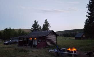
Wildlife viewing: Areas around the cabins offer frequent wildlife sightings throughout the year. A visitor at Hogan Cabin reported, "Found a primitive A-frame structure in the woods about a mile from the cabin. Saw several deer and elk feeding in the field near the cabin, as well as a moose in the marsh along the creek."
Seasonal huckleberry picking: Many forest service cabins provide access to wild huckleberries during summer months. Campers at Powell Campground note that "Huckleberries litter the campground, if you're lucky enough to have an eye out for them," making for a tasty forest-to-table treat while staying in the area.
What campers like
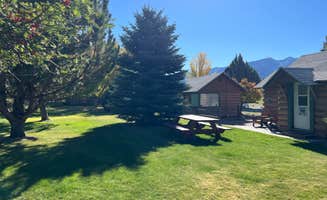
Riverside locations: Many visitors appreciate cabins with water access. At Sula Country Store and Resort, campers can enjoy creek access right from their site. As Scott H. mentions, "Dogs were happy to play in the creek," highlighting the property's natural water features.
Privacy between sites: Cabins and camping areas typically offer good separation between guests. At Powell Campground, Julian P. observed that "The campground has 30+ sites, but they are well separated and it feels very private. The first loop has electricity, the second doesn't."
Historical significance: The Bitterroot area contains numerous historical sites. TRINA B. notes that Sula Country Store location "is a landmark, the Lewis and Clark expedition camped there on their way to discover the west," adding historical context to your stay.
What you should know
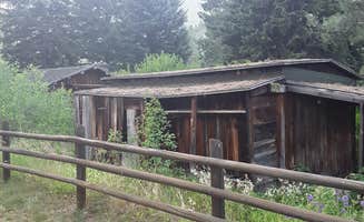
Limited amenities at remote cabins: Forest service cabins typically have minimal facilities. At Hogan Cabin, visitors should note, "The cabin itself is nothing to jump up and down about. With only 2 sets of bunk beds, my wife and I put the bedding on the floor and made a full sized bed. There's no running water so be sure to bring plenty."
Seasonal facility closures: Many forest cabins have limited services in off-seasons. Greg G. experienced this at Powell Campground: "Bathroom and water had already been closed for season," highlighting the need to check facility status before booking.
Cell service limitations: Connectivity varies widely across Angler's Roost On the Bitterroot River and other accommodation options. Annell N. confirmed "No cellular service" at Powell Campground, though noted "Lodge does have wifi," providing a communication option if needed.
Tips for camping with families
Kid-friendly amenities: Some properties offer special facilities for children. Trina B. found that Sula Country Store and Resort has "free put-put golf, horseshoes, tetherball and a small well stocked fishing pond with benches to watch the action or simply admire the beauty of the surroundings."
Multi-day reservations: For family stays near Bitterroot National Forest, book early. At Travellers Rest Cabins & RV Park, Abbas K. notes tent camping includes good value: "$12 gets you campsite showers and toilets, WiFi and coin laundry. Also really great access to the bitterroot valley if you're into hikin and river activities."
Elevation considerations: Many forest cabins sit at significant elevations that can affect young children. The visitor at Hogan Cabin mentions, "Up at 7200ft you get a little winded hiking around," suggesting families should allow time to acclimate, especially with children.
Tips from RVers
Electrical hookup options: RVers seeking power connections should research specific loops. Codie C. advises about Powell Campground: "on loop A, the spots have power, on loop B, they do not. There are 11 spots that are non reservable, however those spots fill up fast."
Reservation timing: Many cabins and Woods Cabin sites have specific reservation windows. A Powell Campground visitor shares, "Reservations close 6 days prior, and then flip over to first come, first serve," noting that "Friday mornings we've had better luck" for last-minute availability.
Dump station availability: RVers should plan for limited dump facilities. Jay M. noted that Powell Campground was "Only lacking a dump station," while another camper mentioned "The dump station was 35 miles away," indicating the need to plan waste management carefully when visiting cabins near Bitterroot National Forest.

 Ranger