Koocanusa Area in Montana features a landscape of forests and lakes. Temperatures range from lows in the 20s Fahrenheit during winter to highs in the 80s during summer. Nearby, visitors can explore Lake Koocanusa and the Kootenai National Forest, offering opportunities for hiking and water activities.
Description
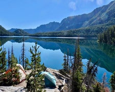
The Koocanusa Area is primarily centered along a narrow 90 mile long Koocanusa Reservoir, formed by Libby Dam. Approximately 60 miles are within the United States. Libby Dam is operated by the US Army Corps of Engineers which provides daily dam tours. Koocanusa Reservoir is the major recreation attraction in this geographic area, providing ideal settings for large watercraft and sailing. The reservoir contains a large and stable population of Kookanee salmon, Kamloops (rainbow) trout, bull trout, West slope cutthroat trout and burbot. Fishing has been reported to be fantastic. There are a number of large developed recreation complexes along the reservoir shoreline including: Rexford Bench, McGillivray, Peck Gulch, and Rocky Gorge. Campgrounds, picnic areas, swimming beaches, boat ramps, as well as day use areas comprise many of the facilities within these developed sites. In addition there are two marina complexes located on the reservoir, one on the southern end, at Cripple Horse, while the northern portion of the reservoir has Mariners Haven Resort near the Town of Rexford. There are also a number of private RV parks, restaurants, and stores near the marinas or within the surrounding communities of West Kootenai, Rexford, Eureka and Libby. Two paved highways running adjacent to the reservoir and extending from Eureka to Libby have been designated by the State of Montana as a Scenic Byway. Traffic is light and views along the roadways are memorable, including glimpses of the Ural-Tweed Big Horn Sheep herd, located on the eastern side of the reservoir along Hwy 37, Various mountain ranges create the geographic setting; Purcell Mountains located west of Koocanusa Reservoir while the Salish Mountains are located on the eastern side. The Koocanusa Area is the perfect setting for year round recreational attractions, including: fishing, water sports, rock and ice climbing, and driving for pleasure, especially during the fall Western Larch color change. Stone Hill climbing area is also located adjacent to Hwy 37 just south of Koocanusa Bridge. The climbing area offers in excess of 70 established climbing routes. Many climbers use the site as an opportunity to hone their climbing skills or to introduce new climbers to the sport. Koocanusa Bridge located at Mile Post 53, approximately 6 miles south of the Town of Rexford. It is the longest and highest bridge in Montana. The bridge connects Hwy 37 to the Western side of the reservoir and recreational opportunities such as road access to the Yaak River valley, the community of West Kootenai, and numerous hiking trails and fishing creeks. Located on the western side is a former fire lookout cabin that is now available for the public to rent. The Koocanusa Area is the perfect setting for a large-water based recreation vacation. Fish Your National Forests: This site can be accessed by Passenger Car; Fish available include: Trout, Native Trout; Types of fishing available include: Wade, Shore, Motorized boat, Float tube, Spin, Bait; ADA Accessible fishing access with boat launch
RV Road Trip Guides

Map & DirectionsKoocanusa Area is located in Montana near Rexford
Coordinates
48.82338658 N
115.26304755 W
Connectivity
 T-MobileNo Coverage
- VerizonNo CoverageVerified by 1 userLast on 6/22/26
 AT&TLTESome Coverage
Connectivity
- T-MobileNo Coverage
- VerizonNo CoverageVerified by 1 userLast on 6/22/26
- AT&TLTESome Coverage
Access
Site Types
- Tent Sites
Features
Drive Time
- 3 hrs 2 min from Coeur d'Alene, ID
- 3 hrs 22 min from Missoula, MT
- 3 hrs 32 min from Spokane, WA
- 4 hrs 57 min from Lewiston, ID

