Claybanks Campground near Baldwin, MI, is surrounded by forested terrain. The area experiences temperatures ranging from the 20s in winter to the 80s in summer. Nearby attractions include the Pere Marquette River and the Manistee National Forest, offering opportunities for fishing and hiking.
Description
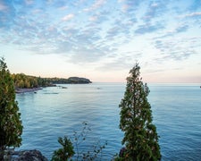
Pere Marquette National Scenic River This river access is on the flies only, catch and release portion of the river. The river bottom is mostly gravel and is a very good area for brown trout. The path to the river borders posted private land on one side before reaching the stairs to the river. The stairs to the river are steep, and will be a workout for those who make the attempt. The pine and oak forest is a good area for wildlife watching and visitors may see a deer or two while heading to the river. Brochure with Map: This brochure is set to print on 11 x 17 paper, landscape (wide) orientation. To print on 8 1/2 x 11 paper set the print area to "shrink to printable area", this will make the text on the page smaller. Flickr Photo Album
RV Road Trip Guides

Map & DirectionsClaybanks Campground is located in Michigan near Baldwin
Directions
From Baldwin - Travel west on 52nd. St. for .25 miles. Turn left and travel south on Astor Rd. for .5 miles. Turn left and go south on S. Claybanks Rd. End at the site.
Coordinates
43.87084806 N
85.88233782 W
Connectivity
 T-MobileNo Coverage
 VerizonLTESome Coverage
- AT&TLTESome Coverage
Connectivity
- T-MobileNo Coverage
- VerizonLTESome Coverage
- AT&TLTESome Coverage
Access
- Walk-InPark in a lot, walk to your site.
Site Types
- Tent Sites
- RV Sites
Features
For Campers
- Trash
- Picnic Table
- Firewood Available
- Phone Service
- Reservable
- Electric Hookups
- Toilets
- Alcohol
- Pets
- Fires
Drive Time
- 1 hr 8 min from Muskegon, MI
- 1 hr 12 min from Grand Rapids, MI
- 1 hr 15 min from Traverse City, MI
- 1 hr 29 min from Midland, MI

