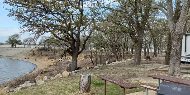
Whitehall Bay, near Fall River, Kansas, is a peaceful spot that offers a nice blend of nature and convenience for campers. With sites that come equipped with electric hookups and direct sewer access, it’s a practical choice for those looking to enjoy the outdoors without sacrificing comfort.
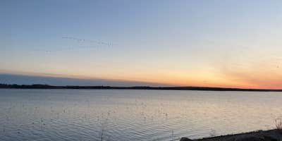
The campground boasts a beautiful lakeside view, perfect for catching stunning sunsets that campers rave about. Many visitors have highlighted the serene atmosphere, making it an ideal place to unwind by the campfire after a day of exploring. One camper noted, “We sat by our campfire and watched the gorgeous sunset,” which captures the essence of what many love about this place.
For those who enjoy a bit of adventure, there’s a boat ramp and a swimming area nearby, along with some playgrounds for the kids. While the road to get there can be a bit bumpy, the natural beauty and tranquility of Whitehall Bay make the journey worthwhile. Just remember to bring your own firewood and any necessary supplies, as there are no markets nearby.
If you’re looking for a quiet escape with a friendly vibe, Whitehall Bay is a solid pick. Whether you’re camping in a tent, RV, or trying out glamping, you’ll find a welcoming spot to relax and enjoy the great outdoors.
Description
Overview
Whitehall Bay Campground is located on the shores of Fall River Lake in Greenwood County, Kansas. Opportunities for outdoor family fun and recreation include swimming, boating, water skiing, camping, picnicking and sightseeing.
Recreation
For birdwatchers and nature lovers, there is an 8,000 acre Fall River wildlife area, where prairie chickens, waterfowl, rabbits, wild turkeys, white tail deer, doves and quail are commonly seen. Over 400 species of birds are protected in this area. Hiking and biking opportunities near Fredonia Bay include the 1.5-mile Casner Creek Trail, which meanders through the forest, opening onto a breathtaking display of wildflowers during spring and summer months, or the 1-mile Turkey Run Trail, which leads visitors through a wooded ravine, over a stream and into a tall grass prairie with an impressive view of the lake.
Facilities
This campground contains four group sites with electric hookups, and 20 family sites with electric. Additional amenities include flush toilets, drinking water, showers, a playground, beach, boat ramp and a dump station.
Natural Features
Rolling prairies and tree-dotted valleys sheltered by limestone-capped ridges surround Fall Lake, which stretches up the picturesque Fall River for 15 miles. This scenic area has a wealth of native wildlife and vegetation.
Nearby Attractions
Fall River State Park is nearby, offering great hiking, fishing and birding along the river. Canoeing is also a popular activity in the park.
Map & DirectionsWhitehall Bay is located in Kansas near Fall River
Directions
From US HWY 400, turn left (north) at mile marker 344 (Z 50 Rd.) 0.09, turn right (east) 2.8 miles across dam, turn left (north) 0.8 miles, turn left (west), 0.7 miles, turn right (north) 1.7 miles to low water crossing, straight (north) 0.1 miles, west 0.4 miles, turn left (south) 1.1 miles to entrance to park.
Address
2453 LAKE ROAD
Fall river, KS 67047
Coordinates
37.6671667 N
96.0726833 W
Connectivity
 T-MobileLTESome Coverage
- VerizonLTESome CoverageVerified by 1 user
- AT&TLTESome Coverage
Connectivity
- T-MobileLTESome Coverage
- VerizonLTESome CoverageVerified by 1 user
- AT&TLTESome Coverage
Access
- Drive-InPark next to your site
- Boat-InSites accessible by watercraft.
Site Types
- Tent Sites
- RV Sites
- Standard (Tent/RV)
- Group
- Tent Cabin
Features
For Campers
- Trash
- Picnic Table
- Phone Service
- Reservable
- Drinking Water
- Electric Hookups
- Toilets
- Alcohol
- Pets
- Fires
For Vehicles
- Sanitary Dump
- Sewer Hookups
- Water Hookups
- 50 Amp Hookups
- Big Rig Friendly
Drive Time
- 1 hr 31 min from Wichita, KS
- 1 hr 59 min from Topeka, KS
- 2 hrs 6 min from Joplin, MO
- 2 hrs 14 min from Lawrence, KS


