Trout Creek near Cascade, Idaho, offers a camping experience surrounded by forested terrain and flowing water. Temperatures range from lows in the 30s Fahrenheit in spring and fall to highs in the 80s during summer. Campers can explore nearby attractions such as Lake Cascade State Park and the Payette River, both offering opportunities for outdoor activities.
Description
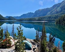
Overview: The Trout Creek Campground, near Landmark, Idaho, offers 5 campsites in a peaceful, remote setting near mountain slopes covered in dense pine forest. Peak season for the campground is typically early June through late September. It can be accessed by most vehicles; however the road is narrow and may be rough in spots. Natural Features: The campground sits in a pretty mountain meadow a stone's throw from several creeks including the scenic Johnson Creek, a tributary of the South Fork Salmon River. Wildlife watchers may see deer, elk, bear and moose. Bald eagles are often spotted soaring overhead. Recreation: The campground is near the trailhead to Thunderbolt Lookout and several trails into the Frank Church - River of No Return Wilderness. Check on the Motor Vehicle Use Map (MVUM) for non-motorized and motorized trails. The area is a popular destination for hikers, mountain bikers and equestrians. Click here for an Idaho OHV safety message. The South Fork Salmon River and Johnson Creek offer opportunities for fishing. Berry picking and hunting are popular pastimes in season. Nearby Attractions: The tiny community of Yellow Pine is north of the campground approximately 15 miles and offers limited services. The popular Yellow Pine Music & Harmonica Festival is held annually in August.
RV Road Trip Guides

Map & DirectionsTrout Creek is located in Idaho near Yellow Pine
Directions
From Boise, Idaho, travel north on State Highway 55 approximately 80 miles to Cascade, Idaho. From Cascade, Idaho, travel north on State Highway 55 only a short distance to the turnoff at the Warm Lake Road (Forest Highway 22). Travel Forest Highway 22 northeast approximately 25 miles. When you arrive at the Warm Lake area, Forest Highway 22 becomes Forest Service (FS) road 579. Continue east along FS road 579, until it intersects with FS road 413 approximately 10 miles. Turn north on FS road 413 and proceed 8 miles to Trout Creek Campground.
Coordinates
44.74600007 N
115.55600075 W
Connectivity
 T-MobileNo Coverage
- VerizonNo Coverage
- AT&TNo Coverage
Connectivity
- T-MobileNo Coverage
- VerizonNo Coverage
- AT&TNo Coverage
Access
Site Types
- Tent Sites
- RV Sites
Features
For Campers
- Drinking Water
- Toilets
Drive Time
- 3 hrs 10 min from Boise, ID
- 4 hrs 24 min from Lewiston, ID
- 4 hrs 54 min from Twin Falls, ID
- 6 hrs 11 min from Walla Walla, WA
