With electric and water hookups for RVs up to 22 feet, South Yuba Campground operates seasonally from April through October 15 at $15 per night on BLM land. The Bureau of Land Management facility provides drinking water, toilets, picnic tables, and ADA-accessible features, though campers should prepare for rough access roads leading to the site.
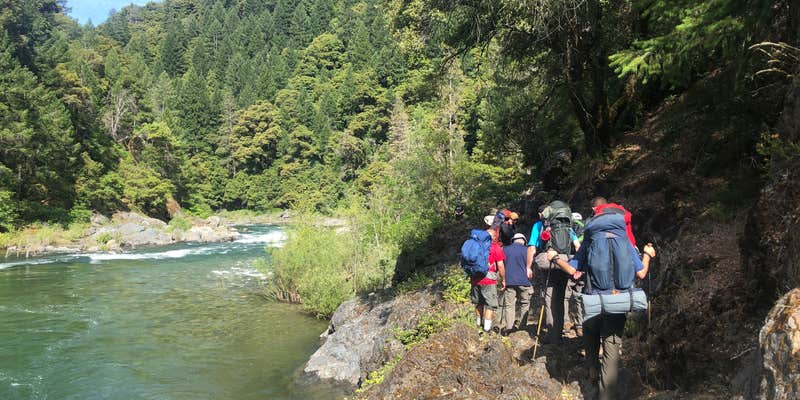
The campground sits along the South Yuba River, where clear water flows through swimming holes that draw kayakers and swimmers. Reviewers consistently highlight the river access as the main attraction, with hiking trails leading upstream and downstream to additional pools. August represents prime time for river activities when snowmelt creates optimal water levels. The forested and open terrain provides sites with direct river views, though poison oak grows extensively throughout the area.
Practical considerations include limited cell service and facility maintenance issues. John T. notes "No cell signal here" and warns that GPS routing from Nevada City directs drivers over a bridge with a 4-ton weight restriction. The composting toilet may be unusable, requiring campers to dig cat holes at least 200 feet from water sources.
The combination of river access, hookup availability, and typically low occupancy makes this campground suitable for RV campers seeking water-based recreation with basic amenities in a less crowded setting.
Description
The South Yuba Wild & Scenic River Recreation Area and National Trail is located approximately 10 miles northeast of Nevada City, California. The Recreation Area is administered by the Bureau of Land Management (BLM); U.S. Forest Service (USFS); and California Department of Parks and Recreation (State Parks/DPR). This 15 mile trail is open to hiking, horseback riding, trail running and mountain biking. The trail is closed to motorized vehicles. The South Yuba Trail takes hikers, mountain bikers, and horseback riders through historic foothill river canyons. Expect to see evidence of California's rich gold rush history.
The South Yuba Wild & Scenic River is approximately one mile from the campground.
Fee Info
Campsites, $5.00 per night, per site. Recreation Pass $2.50 per night, per site. Pay camp fee within 30 minutes of occupying site. Self-pay Iron Ranger. Check-out is by 12 noon. First come first serve basis. No reservation system is available. Eight people maximum per site. Two car maximum per site. Fourteen (14) day camp limit within a 90-day period.
RV Road Trip Guides

Map & DirectionsSouth Yuba Campground is located in California near Nevada City
Directions
From Nevada City: Follow Highway 49 to North Bloomfield Road and travel ten (10) miles to South Yuba Recreation Lands. From the one lane bridge at Edwards Crossing it is approximately 1 1/2 miles on a dirt/gravel road to the campground. PLEASE NOTE: the bridge at Edward Crossing has a 4 ton limit. RV's, trailers and vehicles over 4 tons not recommended. For RV's/Trailers/Vehicles over 4 tons: Recommended Route - Follow Highway 49 to Tyler Foote Crossing. Turn right onto Grizzly Hill Road to the intersection with North Bloomfield Road and make a left turn. Proceed through a small residential area and make a right hand turn into the campground.
Coordinates
39.33890991 N
120.97167597 W
Connectivity
 T-MobileNo Coverage
- VerizonNo Coverage
- AT&TNo Coverage
Connectivity
- T-MobileNo Coverage
- VerizonNo Coverage
- AT&TNo Coverage
Access
- Drive-InPark next to your site
- Walk-InPark in a lot, walk to your site.
- Hike-InBackcountry sites.
Site Types
- Tent Sites
- RV Sites
- Standard (Tent/RV)
- Group
Features
For Campers
- ADA Access
- Trash
- Picnic Table
- Phone Service
- Drinking Water
- Electric Hookups
- Toilets
- Alcohol
- Pets
- Fires
For Vehicles
- Water Hookups


