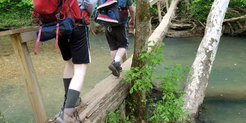
Hikers seeking creek access and canyon exploration will find Clark Cemetery Backcountry Campsite positioned along Turkey Creek, approximately 3.1 miles from the Alabama trailhead. This hike-in site sits just yards from a historic 1800s family cemetery and the Turkey Creek Bridge, creating an atmospheric setting for overnight stays within the Walls of Jericho trail system.
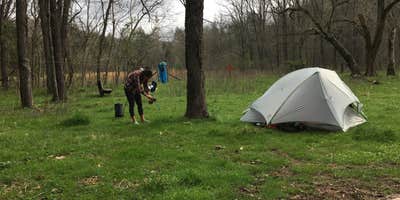
The campsite accommodates multiple groups across its level, moderately-sized clearing. Campers can choose between shaded areas under the tree canopy or sunnier spots depending on their setup preferences. At least six fire rings dot the site, allowing several parties to camp simultaneously without crowding. The abundance of suitable trees makes this location particularly appealing for hammock camping, though tent sites work well on the flatter ground.
Water access remains reliable year-round, though flow levels vary seasonally. Steve V. found Turkey Creek "pretty dry after a very dry summer, but Hurricane Creek is just a short walk away." Spring visits typically offer better water flow for filtering and the area's waterfalls. The site serves as a strategic base for exploring the canyon's rock formations and swimming holes when water levels permit.
Access requires carrying all gear down the switchbacked trail, which campers describe as moderate going in but challenging on the return uphill hike. Cell service proves spotty with most carriers. The rocky terrain favors hammock setups over ground tents in many areas. Nearby camping options include the Walls of Jericho - Turkey Creek Backcountry Campsite and Walls of Jericho - Hurricane Creek Backcountry Campsite for those seeking alternative creek access points.
Pack light for the uphill exit and bring water treatment supplies regardless of creek conditions.
Description
There are hiking trails and horse trails. Both lead into the gorge. A tent-only, primitive camping area is available at the bottom of the gorge not far from the Walls of Jericho natural amphitheater. The hike is about 3.5 miles in length, one way, and is downhill most of the route into the gorge. That, of course, means the walk back will be mostly uphill. It is a strenuous hike, so visitors should wear comfortable shoes and take plenty of water and snacks. The trail is well marked but often is muddy for days after a rain shower. Several streams have to be crossed, so plan on getting wet. Be advised that stream levels rise quickly during thunderstorms and crossing them can be hazardous in swift water. Plan on a minimum of six hours to make the round trip, which includes a two-hour stay in the gorge.
RV Road Trip Guides


Map & DirectionsWalls of Jericho is located in Alabama near Estillfork
Directions
From Nashville take I-24 east toward Chattanooga. Take exit 127 on Highway 64 and turn toward Winchester. Stay on Highway 64 for about 19 miles and turn south on Highway 16. Just after crossing into Alabama, look on the right for a gravel parking area with a yellow gate and an information kiosk. Park there and follow directions on the map at the trailhead. This is the Alabama trailhead, and it affords the shortest route into the Walls of Jericho.
Coordinates
34.9847919 N
86.09608018 W
Connectivity
 T-MobileNo Coverage
- VerizonNo Coverage
- AT&TNo Coverage
Connectivity
- T-MobileNo Coverage
- VerizonNo Coverage
- AT&TNo Coverage
Access
- Hike-InBackcountry sites.
Site Types
- Group
- Equestrian
Features
For Campers
- Phone Service
- Alcohol
- Pets
- Fires
Drive Time
- 58 min from Huntsville, AL
- 1 hr 23 min from Decatur, AL
- 1 hr 30 min from Chattanooga, TN
- 1 hr 31 min from Gadsden, AL


