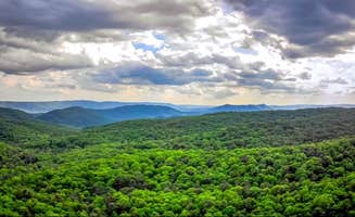
Dispersed camping areas near North Tazewell, Virginia sit within a region of variable elevations ranging from 2,200 to over 5,000 feet in the Appalachian highlands. Winter temperatures can drop below freezing at higher elevations, while summer brings pleasant 70-80°F days. Most rustic camping spots lack basic facilities and require self-sufficiency with water filtration equipment and waste management plans.
What to do
Creek fishing access: Multiple sites along Whitetop Laurel Creek provide anglers with easy access to fishing spots near Little Tumbling Creek. "Laurel bed lake at top is beautiful. Waterfalls on way up and good fishing along the way in tumbling creek," notes camper Betsy W.
Mountain biking preparation: Bring bikes to access trail systems that connect to dispersed camping areas. "We couldn't get enough of this gorgeous area and hit the early spring weather spot on for some fun in the sun," according to one visitor of the region.
Stargazing spots: Higher elevation sites like Whitetop offer exceptional night sky viewing. "Watching the sunset was spectacular, then being able to star gaze," reports Harley G. The minimal light pollution creates optimal conditions for astronomy enthusiasts.
Wildlife observation: Visit salt licks near Scales Trailhead to observe wild ponies. One camper reported, "The sights were magical and the salt lick for the ponies wasn't far," making this a unique opportunity to view wild horses in their natural habitat.
What campers like
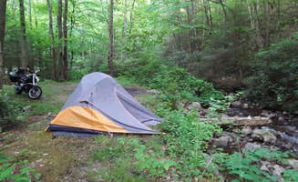
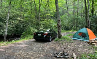
Water noise benefits: Creekside camping provides natural sound barriers. "Camp next to a quiet bumbling creek with beautiful scenery," says Zach C. about Little Tumbling Creek. The constant water sounds mask road noise at sites closer to forest roads.
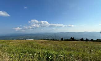
Weather phenomena: Being above cloud level at higher elevations creates unique experiences. "All of a sudden the sun came out and we were ABOVE THE CLOUDS. It was absolutely stunning," shares Whitney B. about their Whitetop Mountain experience.
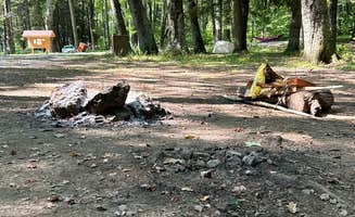
Established fire rings: Many sites contain pre-built fire rings despite their undeveloped nature. "The fire pits are well built and there is plenty of kindling and tinder to find right off the trails," notes Mateo M. about Scales Trailhead Basecamp.
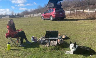
Extended stays permitted: Some areas allow longer camping durations. At Walnut Flats, a camper mentioned, "I stayed just shy of 2 weeks and 1 other came in a few days after me and stayed the whole time I was there and both of us worked on our rv without any disturbances."
What you should know
Road conditions vary dramatically: Many access roads require specific vehicle types. "The road in is...'rocky'. High clearance 4wd needed. Not ADV friendly, unless you're very adventurous," warns Jon M. about accessing Scales Trailhead.
Non-existent cell service: Prepare for complete disconnection at most sites. "Absolutely no verizon service at the site," reports Sean about Washington & Jefferson National Forest Dispersed Sites. Some areas require driving 10+ miles to reach signal.
Variable weather exposure: High-elevation sites experience extreme conditions. "THE WIND IS KILLER. We ended up moving our tent to the other side of the car park at the top," shares Whitney B. about camping at Whitetop.
Required permits: Some locations require special authorization. At Hidden Valley WMA, "Camping is free, technically. (you need to purchase an Access pass from Virginia Wildlife for 4 dollars online, and add a camping authorisation to your account)," explains Rhys R.
Tips for camping with families
Safety planning: Set specific meeting points if hiking separately. "Within 3 miles of these spots along the creek, you will find the famous and gorgeous Virginia Creeper Trail, the Whitetop Laurel Creek, and the Appalachian Trail," making it important to establish clear rendezvous locations.
Weather preparedness: Bring extra layers even in summer months. "The reason I gave it two stars is because if there's any clouds in the sky, you're literally just in a cloud of condensation. Everything is wet. Only camp here if there's clear sky's," warns one camper about higher elevation sites.
Site selection strategy: Choose established campsites with easy vehicle access for family comfort. "This is a small campsite that I believe is on hunting land. You pass a sign going in toward it that states as much. There are two private properties on the road, and you basically just follow it back until you get to this clearing," explains Sean about finding suitable family spots near Mount Rogers National Recreation Area.
Water sources: Filter all drinking water from creeks. "There is no drinking water, picnic tables, or even pit toilet, so come prepared," advises one experienced camper about rustic camping near North Tazewell.
Tips from RVers
Parking area identification: Look for wider pull-offs along forest roads for RV camping. "It is a pull-thru so it would be convenient for trailers, too," notes Charles about a site in the Mount Rogers area, indicating some locations accommodate larger vehicles despite rustic settings.
Level ground assessment: Scout sites before committing. "5 sites, stayed. In the double site. Quiet place with plenty of firewood on the ground," reports Dennis R. about Walnut Flats, one of the more RV-friendly dispersed areas.
Access road evaluation: Check road conditions before attempting access in larger vehicles. "The road to this site is WILD, but doable! I'll leave photos of the worst spots to help you decide whether or not you should drive up to the top," advises Emerald M., who successfully navigated to Whitetop in a 2WD Ford Maverick.
Water planning: Bring all water needed as most sites lack potable sources. "This spot is very nice, close to the water's edge (although no camping allowed lakeside). There's quite a few rings, bear bins, and a porta-loo," notes one camper about facilities at dispersed sites.