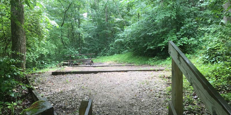
Camper submitted image from Shawnee State Forest Backpack Trail Campsites - 1

View Photos

Camper submitted image from Shawnee State Forest Backpack Trail Campsites - 2
Nature
Camper submitted image from Shawnee State Forest Backpack Trail Campsites - 3
Roads
Camper submitted image from Shawnee State Forest Backpack Trail Campsites - 4
Animals
Camper submitted image from Shawnee State Forest Backpack Trail Campsites - 5
Facilities
pro

Free Camping Collection

Public Campground

Shawnee State Forest Backpack Trail Campsites

Description

Camping on the Backpack Trail is restricted to one of 7 camp areas. Each area has multiple locations for tents, fire rings and a latrine. Most have a cistern nearby with trucked in water.

Suggest an Edit

Location

Shawnee State Forest Backpack Trail Campsites is located in Ohio

Detail location of campground

Directions

Backpack Trailhead (N38° 44.518′ W83° 11.851′). From Portsmouth, take US 52 West to right on OH 125 West. In 6.6 miles, turn left into Shawnee State Park. The Trailhead parking is immediately on the right.

Coordinates

38.741230137102704 N
83.20527261258836 W

Open in Google Maps

Access

  • Hike-In
    Backcountry sites.

Site Types

  • Tent Sites

Features

Have you camped here? Help us improve this campground page.

Add a Feature

FREE established camping

Enjoy camping on government land. Limited or no services at this camping area.

Contact

General Info


2026 Explorer Giveaway

Review Campgrounds. Win Prizes.

Enter to Win

Reviews

Add Review

5 Stars

4 Stars

3 Stars

2 Stars

1 Star

50%
50%
0%
0%
0%

4.5

out of 5

2 Reviews

Reviewed Jul. 7, 2018

A Challenging Backpacking Loop

We took a group of Boy Scouts on a five day backpacking trek of the entire Shawnee Loop. It was a very challenging five days with a lot of up and down hills.

The entire loop is around 36 miles. There are seven campsites along the trail, and all but one has water access, which was really nice on our trek.

The first day we hiked from the trail head parking lot to Camp 1. The camp was a small, secluded grove down in a valley. This made for a nice cool off from the day's heat. The camp has a large grassy area and several smaller campsite offshoots.

The second day we hiked to camp 2 and stopped for water. Unfortunately the water supply seems to have been compromised since we found leaves in the water coming from the faucet. Luckily we have our water filtration system so we quickly filtered the water and were on our way. We then hiked to camp 3 which is very close to Camp Oyo. This was a nice, large camp right next to the creek. We had tons of space. The only bad thing about this campsite was it's proximity to the main road. We heard cars going by all night.

The next day we found a beautiful view on top of the one hill just off a logging road where we stopped for lunch. There was even a picnic table. We then went on to camp 4 which, unfortunately, had been trashed. There was garbage everywhere, likely due to this campsite being close to a road. So, as good boy scouts we cleaned up the trash so that the next group could enjoy the camp. This camp was much like camp 1. Grassy area, small creek, lots of shade in the valley.

We then went on to camp five and we quite disappointed. This is barely a camp at all. It's just a long trail to a small grassy patch. Barely enough room to set up a decent camp. I think this camp has not seen much use.

When we hiked to camp 6 the next day we found the crown jewel of the trail. Camp 6 is absolutely beautiful. The camp is in a pine grove and has a substantial creek running through the middle complete with fairly large fish! Although there was no water access in camp six we were able to refill water thanks to the stream and our filters. We were very bummed to not be camping at camp six.

We then went on to camp 7 for our final night. Camp seven is just like camp 1. It's down in a cool valley with an open patch for tents and lots of good trees for hammocks.

Overall it's a good hiking trail, and very challenging. The only thing I would like to have seen more of would be a more interesting trail. Which cant be helped, really. There aren't any interesting rock formations or caves along the trail. And the views are OK. Nothing too spectacular. My thought is that you do the Shawnee trail for the challenge of the distance, terrain, etc. It's a good training trail for longer treks. I enjoyed it greatly, but don't see myself coming back for some time.

Sitecamp 1, 3, 5, 7
Month of VisitJune
  • Review photo of Shawnee State Forest Backpack Trail Campsites by James W., July 7, 2018
Reviewed Jul. 6, 2017

Preparation is key

Shawnee State Park was totally without any phone signal. Right on the border of Kentucky, in Ohio, you are in the small town almost South.

Beautiful countryside, fortunately I was on Rt 125 when I lost all clue where the park entrance was. Then I saw the Shawnee Range and kept on driving. Definitely get a map because the whole park offers a lot of out door opportunities.

Backpack trail, 23 and 40 miles loops with 7 camping areas, register and enjoy. Equestrians get 70 miles and primitive camping.

The camping area is small ( a good thing ) the restrooms are clean and basic. Showerhouse and laundry. The attendant was super helpful and knowledgeable.

Month of VisitJuly
  • Review photo of Shawnee State Forest Backpack Trail Campsites by Shelly S., July 6, 2017
  • Review photo of Shawnee State Forest Backpack Trail Campsites by Shelly S., July 6, 2017
  • Quick tour off the trail into the top loop of the campground
    Play button icon
  • (21) View All