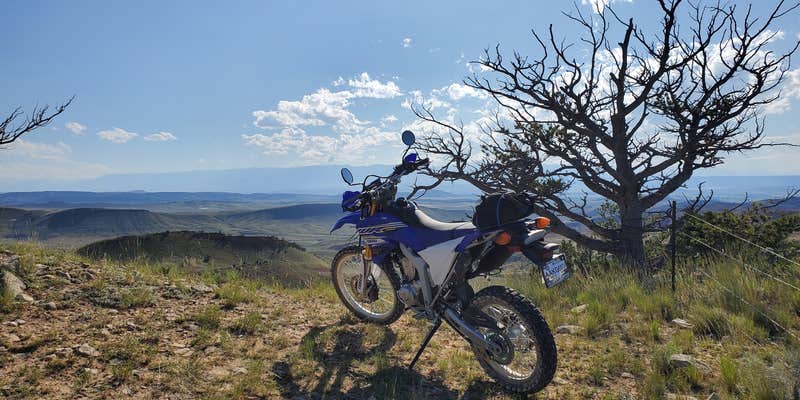
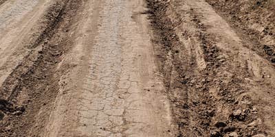
Deep within Custer National Forest, Sage Creek Campground operates as a free, open-circle camping area where visitors can pitch tents or park vehicles anywhere within the designated space. The Forest Service maintains this primitive site from late May through early September, providing drinking water, toilets, and firewood sales. Access requires navigating several miles of heavily rutted private roads that become impassable for standard vehicles during wet conditions, demanding high-clearance 4WD capability.
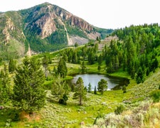
The campground sits in forested terrain near a creek, with covered picnic tables providing shade during summer heat. Wildlife frequently moves through the area, including bison that walk directly through campsites. No pets are permitted, and cell service remains limited. The surrounding forest offers extensive OHV trails and backcountry roads for exploration.
Description
Sage Creek Campground is the only campground in the Pryor Mountains. It is located along the banks of Sage Creek. Big Ice Cave Picnic Ground, and the Bureau of Land Management Pryor Mountain Wild Horse Range are also located in the Pryor Mountains. Numerous motorized trails are located in the Pryor Mountains. See the current year's edition of motor vehicle use map (and legend) for the area and road closures.There is a 16 day maximum stay in all Beartooth Ranger District campgrounds__Camp sites: 12Host: NoMax Trailer Length: 30ftAccessible Facilities: Vault toiletsTrash Pickup: NoFirewood: No. Don't move firewood to other areas or bring in outside firewood.Prevent the spread of tree-killing insects by obtaining firewood near your destination and burning it there.Reservations:No Reservations. This campground does not use a reservation system, it is managed on a first-come, first-served basis.* Please be advised that there is not consistent potable water here. Call the district office to learn if there is water, or plan ahead and bring your own.Directions from the town of Bridger:[This route is not advised for campers or horse trailers. High clearance vehicles are recommended] Drive south of Bridger for 2.8 miles and turn left on Pryor Mountain Road. Drive 12.2 miles until the road dead ends. Turn right to continue on Pryor Mountain Road/ Railroad Grade Rd. Drive 2.8 miles and turn left onto Pryor Mountain Road/ Railroad Grade Rd. In 2.2 miles, turn right onto Railroad Grade Rd. This becomes Forest Road 2500 (Powerline Road). We recommend high clearance vehicles for this section of road. It is rocky and a single track. Drive 6.9 miles and turn right onto Pryor Mountain Road/ Forest Road 2308. Drive 0.3 miles and turn left onto Sage Creek Rd. Drive 0.3 miles to Sage Creek Campground. Roads in the Pryor Mountains become impassable when wet.Powerline Road Access MapFor access with campers or trailers, it is recommended to access the Pryor Mountains from the south, via the Crooked Creek Road. From Bridger, drive 21.5 miles south on Hwy-310 to Warren (a conveyeor belt for a quarry goes over the road). Turn left onto Quarry Rd and drive 6.9 miles (at 4.3 miles, the road name changes to Helt Rd). Veer to the right onto Gyp Springs Rd and drive for 7.1 miles. Turn left onto Helt Rd and drive for 0.2 miles, then veer to the right onto Crooked Creek Rd. Drive 6 miles to the Forest Service boundary. Continue another 3.4 miles to Tie Flats. Turn left onto Pryor Mountain Rd (Forest Road 2308) and drive 7.6 miles. Turn right onto Sage Creek Road and drive 0.3 miles to Sage Creek Campground, on your right. [approximate driving time from Bridger, MT: 2.5 hours].Pryor Mountain Access MapInformation:Beartooth Ranger District6811 Hwy 212Red Lodge, MT 59068(406) 446-2103
RV Road Trip Guides

Map & DirectionsSage Creek Campground is located in Montana near Pryor
Coordinates
45.213877 N
108.554629 W
Connectivity
 T-MobileNo Coverage
- VerizonNo Coverage
- AT&TNo Coverage
Connectivity
- T-MobileNo Coverage
- VerizonNo Coverage
- AT&TNo Coverage
Access
- Drive-InPark next to your site
- Walk-InPark in a lot, walk to your site.
- Hike-InBackcountry sites.
Site Types
- Tent Sites
- RV Sites
- Standard (Tent/RV)
Features
For Campers
- Firewood Available
- Drinking Water
- Toilets
- Alcohol
- Pets
Drive Time
- 1 hr 57 min from Billings, MT
- 3 hrs 34 min from Bozeman, MT
- 4 hrs 57 min from Helena, MT
- 5 hrs from Casper, WY


