
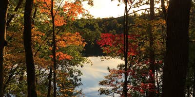
River access and pond-side camping draw visitors to Government Landing Campground, a dispersed Forest Service site along the Manistee River backwaters. The campground operates seasonally with reservations required during summer months, while off-season camping follows a first-come, first-serve system.
Large, well-spaced sites accommodate RVs and trailers, though maneuvering can prove challenging on some spots. Kevin D. notes the location as a "scenic spot right on the pond/dam backwaters" with "very spacious and spread out sites." The river access requires navigating a steep hillside, and the water deepens quickly from shore. Swimming remains possible in the warmer backwater areas, though seaweed can complicate water activities.
Walking trails, bike paths, and ORV routes provide recreation options beyond the water. Sites fill consistently during peak season, with weekend availability particularly limited. The area serves as a base for exploring campgrounds around Manistee National Forest, with additional dispersed options like Government Landing Campsites nearby.
Basic amenities include restrooms within walking distance of most sites, though no water pumps operate on-site. Reserve summer stays well in advance through Recreation.gov, or visit during shoulder seasons for more flexibility.
Description
Manistee National Recreation River This camping area is named for Government Island. The 3 campsites are part of the Forest Services' 41 designated dispersed sites along the Upper Manistee River. The main access road along the powerline is a snowmobile trail in the winter. Brochure with map : Manistee River This brochure is set to print on 11 x 17 paper, landscape (wide) orientation. To print on 8 1/2 x 11 paper set the print area to "shrink to printable area", this will make the text on the page smaller. Flickr Photo Albums Manistee River
RV Road Trip Guides

Map & DirectionsGovernment Landing Campground is located in Michigan near Wellston
Directions
From Brethren - Drive 3.5 miles east on Coates Hwy. Turn right onto Dilling Rd. And drive 2.5 miles. Turn left onto Upper River Rd. and drive 2.5 miles northeast to the entrance of the site.
Coordinates
44.26313 N
85.88884 W
Connectivity
 T-MobilePossible CoverageVerified by 11 usersLast on 7/30/26
- VerizonPossible CoverageVerified by 11 usersLast on 7/30/26
 AT&T5GGood CoverageVerified by 4 usersLast on 7/30/26
Connectivity
- T-MobilePossible CoverageVerified by 11 usersLast on 7/30/26
- VerizonPossible CoverageVerified by 11 usersLast on 7/30/26
- AT&T5GGood CoverageVerified by 4 usersLast on 7/30/26
Access
- Drive-InPark next to your site
Features
For Campers
- Picnic Table
- Phone Service
- Reservable
- Drinking Water
- Toilets
- Alcohol
- Pets
- Fires
DISPERSED CAMPING
Enjoy dispersed camping on government land and leave no trace. Pack in and pack out. No (or limited) services at this camping area. Permit may be required.
PERMIT might be REQUIRED
We curate permit requirements across the US for our PRO members. Try PRO to see if Government Landing Campground needs a permit.
Drive Time
- 1 hr 20 min from Traverse City, MI
- 2 hrs 8 min from Midland, MI
- 2 hrs 8 min from Grand Rapids, MI
- 2 hrs 10 min from Muskegon, MI


