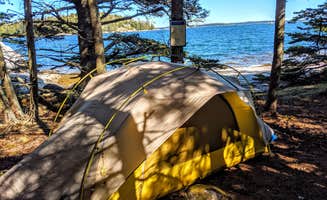
Dispersed camping near Spruce Head, Maine requires wilderness skills and marine navigation experience. The four main islands used for primitive camping in this area range from 6-15 acres in size and are situated in waters that can experience significant fog and tidal changes up to 10 feet. These islands exist within a protected marine environment where weather conditions can change rapidly, requiring campers to monitor VHF weather channels and carry appropriate safety equipment.
What to do
Island hiking options: Marshall Island offers 10 miles of trails through diverse terrain and ecosystems. The island's interior trail network provides opportunities to explore meadows and dense forests while a perimeter path follows the rocky coastline. A review notes: "The trails on Marshall Island are well-maintained and allow you to explore the entire 985 acres of preserved land. We spent two full days hiking and still didn't cover all the ground," from Marshall Island.
Wildlife viewing opportunities: The Gulf of Maine supports diverse marine wildlife visible from island shorelines, including harbor seals, porpoises, and numerous bird species. Bring binoculars for early morning or evening viewing when activity increases. According to campers at Wheat Island: "The birding here is exceptional. We spotted black guillemots, eider ducks, and even caught glimpse of a bald eagle fishing near shore in the early morning hours," from Wheat Island.
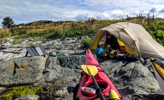
Kayak navigation practice: The protected waters between islands offer opportunities to practice marine navigation skills in varying conditions. The short distances between some islands make them suitable for novice sea kayakers when conditions permit. "This is a perfect island for those new to sea kayak camping as the sandy shore, which is exposed for a good portion of the day, is easy to land on and a short walk to a trail into the woods," notes one reviewer about Buckle Island.
What campers like
Small site seclusion: Doliver Island provides a truly remote camping experience with minimal facilities and space for just one small tent. "This island is small with barely a tent space, but a good stop for us on our 9 day journey and a perfect launching spot for crossing Jericho Bay (4.5 miles) to Marshall Island the next day. Gorgeous shell covered beach and a beautiful view of Isle au Haut, just next door," notes one camper from Doliver Island.
Ecological preservation: The Maine Coast Heritage Trust maintains Marshall Island as a conservation area with minimal human impact. One camper mentions: "If you do a beach clean-up during your stay and send in a picture, you will receive a Maine Coast Heritage Trust hat!" This reflects the organization's commitment to preserving these natural spaces.
Astronomical viewing: The minimal light pollution and open water create exceptional conditions for night sky viewing from several islands. September through October typically provides the clearest night skies with minimal fog interference.
What you should know
Navigation and landing challenges: Each island presents unique landing conditions dependent on tide, wind, and shoreline composition. "This can be a tricky island to land on at high tide, so plan accordingly," warns a visitor about landing conditions.
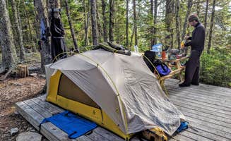
Complete self-sufficiency required: All water, food, and waste management supplies must be packed in and out. No potable water sources exist on any islands, and a minimum of 2 gallons per person per day is recommended.
Maine Island Trail Association membership: Access to these islands requires MITA membership, which provides detailed maps, landing information, and conservation guidelines. Annual membership costs approximately $45 for individuals and $65 for families.
Tips for camping with families
Best beginner-friendly options: For families new to island camping, Buckle Island provides the most forgiving access point with its sandy shoreline. The short distance from mainland launch points makes it accessible for families with mixed paddling abilities.
Safety equipment requirements: All family members should wear appropriate PFDs rated for open water conditions. Carry marine VHF radios, emergency signaling devices, and comprehensive first aid supplies suitable for remote locations.
Weather monitoring protocol: Establish a regular schedule for checking weather conditions via marine band radio. Morning and evening checks are minimal, with additional monitoring when conditions appear unstable. Families should have a clear plan for seeking shelter or evacuation if weather deteriorates.
Tips from RVers
Kayak transport considerations: RV campers accessing these islands must find suitable parking for extended periods at boat launch facilities. The nearest secure long-term parking for RVs is available in Stonington, approximately 10 miles from primary launch points.
Equipment rental options: Several outfitters in the region offer sea kayak rentals and guided trips to these islands, eliminating the need to transport personal watercraft on RVs. Advance reservations are essential during peak season (July-August).
Mainland staging logistics: RV travelers should utilize mainland facilities for showers and waste disposal before and after island visits. Stonington offers the most comprehensive services including potable water, dump stations, and provisioning options within 15 miles of primary launch points.