Indian Point Camping Area in Idaho is surrounded by forested terrain with a mix of trees and open spaces. Temperatures can range from lows in the 30s Fahrenheit during cooler months to highs in the 80s during summer. Nearby, visitors can explore Payette National Forest and enjoy activities such as hiking and wildlife viewing.
Description
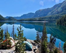
This dispersed walk-in 3 unit campground is located along the East Fork of the South Fork of the Salmon River. The site is popular with boaters floating the East Fork of the South Fork Salmon River. Adjacent to the road, so can be noisey and dusty.
RV Road Trip Guides

Map & DirectionsIndian Point Camping Area is located in Idaho near Payette National Forest
Directions
This site is approximately 13 miles northwest of Theodore Roosevelt Dam. DO NOT ATTEMPT TO CROSS TONTO CREEK WHEN IT IS FLOWING!! From Mesa: Take the State Hwy. 87/Beeline Highway north for about 60 miles to the junction of State Hwy.87 and State Hwy. 188. Turn right and follow State Hwy. 188 for 23 miles to its junction with Forest Road (FR) 60/A Cross. Turn left and continue across Tonto Creek for 2 miles to FR 661/Indian Point. Continue on FR 661 for one mile to the site. The entire route (except for the first ¾ mile of FR 60 where it crosses Tonto Creek) is paved. From the Globe area: Take State Hwy. 188 north for 30 miles to the junction of State Hwy. 188 and State Hwy. 88. Continue on State Hwy. 188 over the bridge for another 11 miles to Forest Road (FR) 60. Turn right onto FR 60 and continue to site as described above. Click Here For Vicinity Map. Clik Here For Campground Map.
Coordinates
45.0133287 N
115.71610075 W
Connectivity
 T-MobileNo Coverage
- VerizonNo Coverage
- AT&TNo Coverage
Connectivity
- T-MobileNo Coverage
- VerizonNo Coverage
- AT&TNo Coverage
Access
Site Types
- Tent Sites
Features
Drive Time
- 4 hrs 21 min from Boise, ID
- 4 hrs 44 min from Lewiston, ID
- 6 hrs 31 min from Walla Walla, WA
- 7 hrs from Missoula, MT

