





Emily A. Ranger
Wild and Senic Trinity River Grapevine River Access Dispersed Site
Here are the correct coordinates: 40°46'48.5"N 123°07'43.7"W It sits 1 hr and 15 mins from Redding
12 campgrounds · Check availability for any dates.
Several dispersed camping options exist near Burnt Ranch, California on Bureau of Land Management (BLM) lands. Lacks Creek BLM Management Area provides free primitive camping with established sites along Pine Ridge Road, approximately 17 miles east of Highway 101 via Bair Road. Additional dispersed camping can be found at Groves Prairie Camp, accessible via forest service roads from either Willow Creek or Hawkins Bar. Redwood Creek Dispersed Camp allows backcountry camping along the creek banks, while Cline Gulch BLM offers riverside primitive sites about 45 minutes from Redding.
Access roads to these dispersed campsites typically require careful navigation on gravel and dirt surfaces. The drive to Lacks Creek involves a windy gravel road with some confusing intersections and occasional low-hanging branches. According to one visitor, "Follow Pine Ridge Road all the way till you hit dispersed sites with picnic tables and fire pits on the right." Most areas have no drinking water, so campers must bring their own supplies. Cell service varies by location, with some spots receiving limited coverage. Fire restrictions may apply seasonally, and campers should verify current conditions before traveling. Several locations have vault toilets, but no other amenities or services are available.
Many sites feature scenic views and natural surroundings that attract visitors. At Lacks Creek BLM, campers report "beautiful views" and access to hiking and biking paths directly from campsites. One camper noted the area has "fire rings, a nice running/bike path right in the camp ground," but warned about ticks in the area. Groves Prairie Camp provides a secluded meadow setting with three designated sites, each containing a picnic table and fire ring. North Trinity Lake offers lakeside camping without facilities but provides open field and wooded options. Most locations remain relatively quiet with limited traffic, though Cline Gulch reportedly experiences occasional target shooting activity in the vicinity.
"Note the gps coordinates take you to the right of the sign at the top of the hill after you turn off the main road. I would recommend going straight. Just follow it to the end."
"The whole BLM management area is well developed and has signs to guide you. There are spots all along pine ridge road. Campsites have picnic tables and fire rings."
"Both ways are via forest service roads that are "fair". There are 3 sites, each with a picnic table and fire ring. There is one vault toilet that was stocked with 'the papers'. "
"There is a beautiful little creek right next to the campsite."
"the directions in the review were accurate and easy to follow. the road gets pretty steep, though 90% is paved and only turns to gravel at the end. no water source that we could find for filtering, so"
"follow titlow hill road until you get to a fork in the road with 3 roads and a take a left. follow it up past the cell tower and drive until you reach 2 pullouts close together where the bottom one has"
"Stop by this place you boondocker (and fisherman too). Alkens Recreation Area is a GEM! It's free, it has the Klamath nearby, it's got a sunny location, it's away from the coastal climate."
"But it still has camp sites and a little further in there is dispersed very close to the river. It was secluded and great."
"As long as you’re okay with very shallow water crossings- you can walk pretty far if all the spots close to the trail are closed."
"Dispersed camping along the river banks after walking through the Tall Trees hike. Easy overnighter."
"This site is nothing special but it’s the only BLM I could find in the area. We stopped on the way up to Shasta. You don’t need ground clearance or 4wd to get there."
"No amenities of any kind."
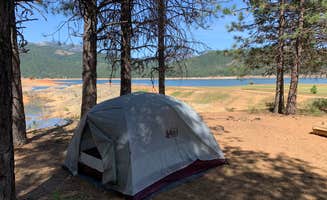
"This is disbursed lakeside camping with no facilities."
"dispersed camping
- no amenities
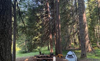
- a beautiful open field with the woods in the back and Trinity lake in the front
- you could camp in the open field or in the woods"
"Campsites are close together, one is more isolated and overlooks the trail. 2 bear boxes and 4 picnic tables. Remote but had amenities."
"It is located up the hill from the sign announcing it along the trail, look carefully if like me you've night hiked to get here."
RangerHere are the correct coordinates: 40°46'48.5"N 123°07'43.7"W It sits 1 hr and 15 mins from Redding

 Guide
I love these sites because NPS allows you to camp all along the gravel by the creek which from what I saw- goes extremely far into the park. As long as you’re okay with very shallow water crossings- you can walk pretty far if all the spots close to the trail are closed.
Hiked in from Tall Trees Grove parking which requires a free online permit because they send you the code to a locked gate. It was 2.7 mile hike down to the gravel, it’s all downhill so remember that when you are leaving.
Creek provided access to water easily and access to hiking trails, giant redwoods, beautiful scenery, it’s very remote so no service but likely to see other people. I imagine it might be packed on weekends. If you camp by Tall Trees Trial you’re likely to see people some sites there isn’t much privacy. Campfires OK on gravel.
Pack in pack out, leave no trace, no bathrooms so dig a hole!
 Guide
This was a pretty nice spot. Only about 3 campsites with tables and fire pits, but a few others along the road. The view was nice and the sunsets were amazing! It was very quiet at night, no noise from the road. There are some trail heads close to the campsites, but some are very overgrown. The only downside was lots of mosquitoes, even out after dark. The road was also very rocky, but manageable. Be careful to go slow and avoid sharp rocks, because I ended up with a flat tire on the way out. Cell service isn't bad, but the nearest town is about 1 hr away. Weather was warm and dry, with some light mist at night. We did see a black bear on our way down the road, but not much other wildlife besides birds.

 Traveler
Coordinates lead to some private driveway. The road I used to get down by the lake is 41.01849956,-122.696283. Once you get down by the water there is a ton of space for you to set up camp by the water or more inland.
TravelerEverything about it was amazing. Exact coordinates were off but look for little roads off the main road. There were very few people and plenty of space. We were able to camp right by the lake undisturbed.
 Ranger
This place first off is 45min to an hour from 101. Secondly it rained all night and my RTT is soaked. Once I took the rain fly down it was bad. Needless to say trying to get to a dry place to allow my tent to dry. I will say I absolutely love Offroad and this is a forest service road that goes up the mountain. Great place if it’s not raining and you don’t plan on sleeping in your RTT in the rain. I’ve never left a bad review but If I could give this 0 stars I would.
 Ranger
We arrived late after dark and found the area to be quite far off the beaten path. It was another overnight stop for us while traveling through the area.
We located the designated spot, but the signage was confusing. There were numerous signs stating “No Camping” and “Day Use Only,” even though there were established fire pits present. It was difficult to tell whether the specific area we were in allowed overnight stays while the surrounding area did not.
The river was nice, and the area itself is pretty. However, the road leading to the site is rough and best suited for 4x4 vehicles. There is also a fairly steep downhill section to reach the parking area.
One positive was the solitude. We didn’t see a single vehicle pass by during our entire stay, so it was very peaceful and quiet throughout the night.
I’m giving this location one star, not because of the scenery, but because of the confusing camping regulations. If the camping situation had been clearly marked, I would probably rate it two or three stars. Stay at your own risk and verify the rules for yourself before spending the night.
There are no hookups, no water, and no amenities. At least from the spot where we stayed, there wasn’t even a maintained trail down to the river.

 Scout
Road is one lane, gravel, windy for the last part of the trek up witj some deeper ruts (we did fine going slow in a stock Honda Accord). Plenty of mountain bike, hiking trails with difficulty levels and map! There's a first camping spot with the easy loop hiking trail that is just by itself and a little further down the road is 3 or 4 other camping spots near the bathroom and additional trails. Absolutely will be coming back!!!
 Scout
You aren't allowed to camp anywhere on Cline Gulch road as of 2026.
Dispersed camping near Burnt Ranch, California offers access to remote sites along the Trinity River and within Redwood National Park. The area sits at approximately 1,200 feet elevation with surrounding mountains reaching up to 4,000 feet, creating varied terrain for campers. Summer temperatures typically reach the 90s while winter lows drop to the 30s with occasional snow at higher elevations.
Hiking trails: At Redwood Creek Dispersed Camp, visitors can access backcountry trails through impressive forests. "Dispersed camping along the river banks after walking through the Tall Trees hike. Easy overnighter," notes Sam S. This area requires a free permit obtained online with a gate code for access.
Water activities: The Trinity River provides swimming and fishing spots during warmer months. North Trinity Lake offers "a beautiful open field with the woods in the back and Trinity lake in the front," according to Karen T., making it suitable for water recreation. Lake levels fluctuate seasonally.
Mountain biking: Several sites connect to mountain biking paths. At Lacks Creek BLM, Derrick H. reports "the whole BLM management area is well developed and has signs to guide you" with biking paths directly from campsites.
Secluded settings: Groves Prairie Dispersed Camp offers quiet meadow camping away from crowds. Greg B. describes it as "secluded camp well worth the effort to find" with "3 sites, each with a picnic table and fire ring" and notes extremely unreliable cell service.
Scenic locations: Many dispersed camping areas near Burnt Ranch feature river views. At Cline Gulch BLM Dispersed, Kevinae B. found "an awesome creek right next to us" and noted "it was super secluded and quiet. No one else drove by at all during the two days we stayed."
Unexpected wildlife: Campers report diverse wildlife sightings across the region. "We even saw wild horses driving up!" mentions Toni K. about the road to Lacks Creek. Other visitors report deer sightings and bald eagles near waterways.
Road conditions: Access to many sites involves navigating challenging roads. Jules S. warns about Lacks Creek BLM: "Tried to camp here with a 20ft travel trailer and I turned around before I even made it to the gravel road. Road is narrow and steep with low hanging trees."
Wildlife concerns: Ticks are common throughout the region, especially in warmer months. "My dog and I both got bitten by ticks - and we woke to find 8 other dead ticks in our bed," cautions Hillary S. about her stay at Cline Gulch.
Cell service: Connectivity is limited or nonexistent at most sites. Scout G. reports about Lacks Creek: "I was planning on staying here but had no service for miles with Verizon. Not just spotty service, literally nothing until I drove back down 15 minutes."
Facilities: Most dispersed camping areas have minimal infrastructure. Aikens Creek Recreation Area "seems to have been a legit National Forrest campground that is no longer maintained. But it still has camp sites and a little further in there is dispersed very close to the river," according to Jordan H.
Water safety: Bring proper flotation devices if camping near Trinity River or creek areas. At Redwood Creek, Leah H. advises: "You WILL cross a creek! The rocks are PAINFUL! Bring your sandals! We did not and that part sucked."
Preparation for remoteness: Pack all necessary supplies as stores are distant from most sites. Greg B. notes about Groves Prairie Camp: "There is NO trash service or cans and NO POTABLE WATER. There is a tiny creek running nearby if needed."
Navigation help: Download offline maps before arrival as many roads aren't well-marked. Daniel F. had difficulty accessing Redwood Creek Dispersed Camp: "Access road is gated after a couple of miles, so unable to even get close." Without the required permit containing the gate code, access is impossible.
Size limitations: Larger rigs should avoid most dispersed sites near Burnt Ranch. At Cline Gulch, Laura M. cautions: "Would recommend larger rigs avoid this area due to the number of low hanging tree branches."
Site selection: Arrive early to secure level parking at undeveloped areas. Nate T. mentions about Lacks Creek BLM: "Takes about 35 minutes to get to the top but it's worth it. Tables, bathroom, and fire pits are in the main area."
Alternative options: Consider improved campgrounds if weather conditions are uncertain. Casey B. found at Cline Gulch that "the rest of the spots weren't near water and were just open fields directly in the sun," making shade a premium commodity.
Frequently Asked Questions
Which is the most popular dispersed campsite near Burnt Ranch, CA?
According to TheDyrt.com, the most popular dispersed campground near Burnt Ranch, CA is Lacks Creek BLM with a 4.3-star rating from 22 reviews.
What is the best site to find dispersed camping near Burnt Ranch, CA?
TheDyrt.com has all 12 dispersed camping locations near Burnt Ranch, CA, with real photos and reviews from campers.
Keep Exploring