Rough access roads lead to this small Forest Service campground positioned near Mill Creek in the Lassen National Forest. The site accommodates RVs up to 20 feet and requires reservations, though no pets are allowed on the property. Basic toilet facilities serve the camping area, while the nearby creek provides fishing opportunities for anglers.
The $75 nightly fee reflects the remote location and limited amenities available at this drive-in campground. Campers seeking additional options in the region can explore camping near Lassen National Forest, or consider Black Rock Campground located 1.6 miles west for an alternative Forest Service experience.
Description
Overview
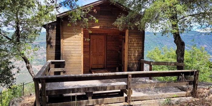
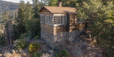
McCarthy Point Lookout was constructed in 1936 by the Civilian Conservation Corps for use in spotting wildfires. During World War II, the lookout served as part of an aircraft defense monitoring system that extended throughout California. The lookout is accessible by vehicle, but a high-clearance vehicle is recommended. Guests must walk approximately 1,000 feet along a paved trail to reach the lookout from the parking area. This is a high cliff area, so caution is advised. The cabin offers several creature comforts, but guests may need to bring some supplies and gear for their stay. The scenic views and remote location make McCarthy Point Lookout an ideal retreat.
Recreation
The lookout is an excellent base for exploring the recreational opportunities of the Ishi Wilderness. Many hiking and equestrian trails crisscross the Wilderness. Special fishing regulations are in effect for Mill and Deer Creeks within the Wilderness. Please check the State of Californias Fishing Regulations before fishing. A valid California fishing license is required.
Natural Features
The lookout is perched at an elevation of 3,600 feet on the southern end of Mill Creek rim overlooking scenic Mill Creek Canyon and the Ishi Wilderness. The cabin is tucked into a stand of mixed evergreens. McCarthy Point is located within a state game refuge that protects species like wild hog, mountain lion, black bear, coyote, bobcat, Tehama deer and rabbit. A variety of raptors nest on rock cliffs in the nearby Ishi Wilderness, including hawks, eagles, falcons and owls. Other common bird sightings include wild turkey, quail, canyon wrens, band-tailed pigeons and myriad songbirds.
Nearby Attractions
Ishi Wilderness
RV Road Trip Guides


Map & DirectionsMccarthy Point Lookout is located in California near Mill Creek
Directions
From Red Bluff, drive east on Highway 36 toward Lassen National Park and Chester. Turn right onto Paynes Creek Loop in Paynes Creek, then turn right on Plum Creek Road (County Road 202) and continue for about 9 miles to the junction of County Road 707B (Forest Service Road 28N29/Ponderosa Way). Turn right and follow this road past Black Rock Campground until you reach Forest Service Road 27N08. Turn left and drive less than a mile to road 27N21. Turn left and proceed to the McCarthy Point Lookout. Please call the Almanor Ranger District for alternate road directions if needed.
Address
T27N R3E SEC 18/19
CA
Coordinates
40.1877778 N
121.6833333 W
Connectivity
 T-MobileNo Coverage
- VerizonNo CoverageVerified by 2 usersLast on 7/23/26
- AT&TNo Coverage
Connectivity
- T-MobileNo Coverage
- VerizonNo CoverageVerified by 2 usersLast on 7/23/26
- AT&TNo Coverage
Access
- Drive-InPark next to your site
Site Types
- Cabins
Features
For Campers
- Reservable
- Toilets

