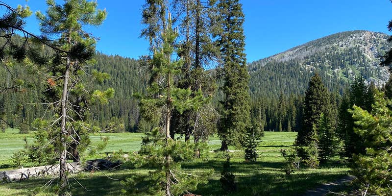
Within Whitman National Forest, West Eagle Meadow Campground provides drive-in access to high-elevation camping at 5,400 feet. The Forest Service manages this small campground with basic amenities including one vault toilet and picnic tables at each site. Campers reach the area via approximately 20 miles of dirt road, which reviewers describe as rough but passable for small trailers and tent camping.
Sites spread around a paved loop above the meadow, offering access to West Eagle Creek and nearby hiking trails. The campground serves as a base for day hikes to Echo and Traverse Lakes. Deadwood collection for campfires is permitted, and the area allows alcohol but prohibits pets. For additional camping options, consider campgrounds near Whitman National Forest throughout the region.
Description
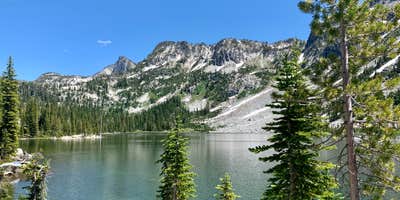
The West Eagle Meadows Trailhead is one of the__'late season' trailheads__to open in the early summer due to the area's heavy snow accumulation and high elevation. Located near West Eagle Creek and meadow, this site is__frequented by hikers and equestrians alike who want to enjoy a day or extended trip into the Eagle Cap Wilderness area. The combination trailhead and equestrian camp__offers parking facilities for both stock and non-stock users, and has hitching rails, a loading ramp and feed bunks.The West Eagle trail provides access to Echo, Traverse, Diamond and Tombstone lakes as well as a beautiful trip along the Minam River. You can also access many other destinations in the wilderness from this trail. Fishing and wildlife viewing opportunities abound as you travel through diverse landscapes of meadows, lakes, and mountains.Adjacent to the trailhead is the West Eagle Meadows Campground__with tent and walk-in campsites and a picnic area.A printable map and additional information about the area.
RV Road Trip Guides


Map & DirectionsWest Eagle Meadow Campground is located in Oregon near Union
Directions
From La Grande, Oregon, travel south on State Highway 203 for about 14 miles to Union, Oregon; In Union turn left on East Beakman Street and continue on Highway 203 for 14 more miles to Catherine Creek Summit; At the summit turn left on Forest Road 77 and follow it for 15 miles to the campground entrance on your left side after the West Eagle Creek crossing.From Baker City, Oregon head north on Interstate 84 for 5 miles to exit 298 (State Highway 203); Turn right off Interstate 84 to State 203 Highway and travel 18 miles to Medical Springs, Oregon; In Medical Springs turn right on Big Creek Road and go 1.5 miles to Forest Road 67; Turn left on Forest Road 67 and go about 14 miles to Forest Road 77; Turn left on Forest Road 77 and go about 5 miles to the campground entrance which is on your right before the West Eagle Creek crossing.Advisory: Forest Road 77 is graveled, and the last 4 miles are extremely rough and not recommended for passenger cars or trailers.
Coordinates
45.078267 N
117.475456 W
Connectivity
 T-MobileNo Coverage
- VerizonNo Coverage
- AT&TNo Coverage
Connectivity
- T-MobileNo Coverage
- VerizonNo Coverage
- AT&TNo Coverage
Access
- Drive-InPark next to your site
- Walk-InPark in a lot, walk to your site.
- Hike-InBackcountry sites.
Site Types
- Tent Sites
- Group
- Equestrian
Features
For Campers
- Toilets
- Alcohol
Drive Time
- 3 hrs 2 min from Walla Walla, WA
- 3 hrs 17 min from Kennewick, WA
- 3 hrs 21 min from Boise, ID
- 4 hrs 35 min from Lewiston, ID


