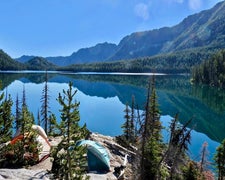
Anglers and paddlers find direct access to both Fisher River and Blue Springs Lake at this Forest Service campground in northwestern Montana. The site sits within forested terrain that opens to lake views, with no pets allowed per management regulations.
Located in the Kootenai National Forest, Fisher River Area provides a base for water-based recreation and forest exploration. The mix of wooded and open areas accommodates different camping preferences, while the creek proximity adds another water feature to the setting. For broader regional options, campers can explore places to camp around Kootenai National Forest. Reserve ahead during peak fishing season when lake access drives higher demand.
Description
The Fisher River Area is the watershed formed by the four forks (West, East, Silver Butte, Pleasant Valley) of the Fisher River and Wolf Creek. The Area is dominated by intermingled ownership, with Plum Creek Timber Company being the major land owner. This area is bordered on the east by the Flathead National Forest and the south by the Lolo National Forest. The Fisher Area is bisected by US Highway 2 running west to east. The Chain of Lakes consisting of more than 20 lakes is located adjacent to US 2. These lakes offer summer camping/picnicking, fishing, and water sports. Ice fishing is popular on the Chain of Lakes. The Salish Mountains are located north of US 2 and the Cabinet Mountains are located south and west of US 2. Peaks in these Ranges exceed 6500’ elevation. Road densities are high in this Area making access quite easy. More than 100 miles of summer use trail are open and available in this Area. Two developed campgrounds provide facilities for camping and picnicking. The Fisher River Area is a favored destination for big game hunters in the fall.
RV Road Trip Guides

Map & DirectionsFisher River Area is located in Montana near Blue Springs Lake
Coordinates
48.35442047 N
115.03836036 W
Connectivity
 T-MobileNo Coverage
- VerizonNo Coverage
- AT&TNo Coverage
Connectivity
- T-MobileNo Coverage
- VerizonNo Coverage
- AT&TNo Coverage
Access
Site Types
- Tent Sites
Features
Drive Time
- 3 hrs 10 min from Coeur d'Alene, ID
- 3 hrs 37 min from Missoula, MT
- 3 hrs 40 min from Spokane, WA
- 5 hrs 5 min from Lewiston, ID

