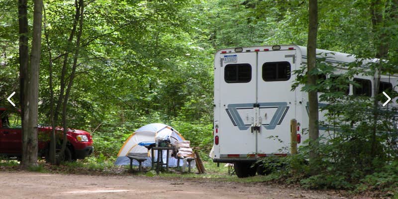
Hungerford Lake Campground sits within Manistee National Forest, accessible by vehicle though campers should expect rough road conditions leading to the site. The US Forest Service manages this year-round facility, which accommodates both established campsites and dispersed camping options across forested and open terrain.
The small lake works well for kayaking but prohibits motorized boats, creating a quieter water experience. Horse staging areas and hiking trails provide additional recreation opportunities beyond the shoreline. Basic amenities include drinking water, toilets, and picnic tables, with campfires and pets permitted throughout the property. Campers exploring the broader region can find campgrounds around Manistee National Forest for additional options.
Description
Hungerford Lake Recreation Area The Hungerford Recreation Area is a nonmotorized area consisting of over 6,500 acres of National Forest System lands. The area provides opportunities to hike, snowshoe, cross-country ski, horseback ride, mountain bike and enjoy the National Forests. The horseback riding and mountian biking trails are two seperate trails. The two trails cross each other at several locations, but "You Are Here" maps are located at trail junctions to aid in navigation. The trail is marked with blue diamonds for the mountain bike trail with a bike symbol and blue diamonds with horses for the horse trail. Boat Launch/Lake campsites - The 30-acre lake offers a variety of fishing and boating opportunities. There are two campsites near the lake. Horses are not permitted in this area or in the lake. This site is particularly scenic during the fall. There is mixed federal and private ownership around the lake. Family Campground - The horse trail and mountain bike connector trails located in the campground. The horseback trail connector trail is located near the group site. The trail camp is very popular during the summer with horseback trail riders. The loop campground is nestled in among a variety of leafy green tress. Horseback Riding - There are over 40-miles of premier horse trails in the Hungerford Recreation Area. Mountain Biking - There are two-loops for mountain bikes, creating a 10-mile trail. Scenary and Topgraphy - The trails go through heavily forested areas of oak, maple, aspen, and red and white pine. At times riders will cross or utilize roads. Parts of the trails are suitable for less experienced riders, while other segments offer a more experienced riding opportunity. The topography ranges from hilly to very hilly. Riders will experience a range in scenery as they ride through the heavily forested areas and into open fields and meadows. Brochure with map: This brochure is set to print on 11 x 17 paper, landscape (wide) orientation. To print on 8 1/2 x 11 paper set the print area to "shrink to printable area", this will make the text on the page smaller. Flickr Photo Album
RV Road Trip Guides

Map & DirectionsHungerford Lake Campground is located in Michigan near Big Rapids
Directions
From Big Rapids - Travel west on M-20 for 8.5 miles. Turn right and travel north on Cypress Ave. for .5 miles. Turn right and travel east on Hungerford Lake Dr. for .5 miles. Turn left and travel north on Forest Rd. 5134 for .5 miles. The site is located on the left.
Coordinates
43.70174127 N
85.62073328 W
Connectivity
 T-MobileNo Coverage
 VerizonLTESome Coverage
- AT&TNo CoverageVerified by 1 userLast on 7/27/26
Connectivity
- T-MobileNo Coverage
- VerizonLTESome Coverage
- AT&TNo CoverageVerified by 1 userLast on 7/27/26
Access
- Drive-InPark next to your site
- Walk-InPark in a lot, walk to your site.
- Hike-InBackcountry sites.
- Boat-InSites accessible by watercraft.
Site Types
- Tent Sites
- RV Sites
- Standard (Tent/RV)
- Group
- Tent Cabin
- Equestrian
Features
For Campers
- Picnic Table
- Drinking Water
- Toilets
- Alcohol
- Pets
- Fires
Drive Time
- 49 min from Grand Rapids, MI
- 1 hr 5 min from Muskegon, MI
- 1 hr 27 min from Traverse City, MI
- 1 hr 28 min from Midland, MI

