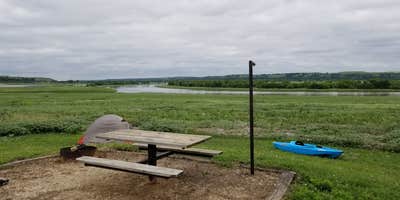
Anglers can cast lines into the Big Blue River and Tuttle Creek Lake from this state park campground that offers both drive-in and boat-in access. Fancy Creek provides full hookups for RVs along with drinking water, restrooms, and shower facilities, though some areas may have vault toilets depending on the specific site. The campground spreads across varied terrain near the creek and reservoir, with some sites featuring shelters and trailhead access for hiking and biking.
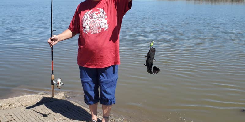
Water levels at this man-made reservoir can fluctuate due to maintenance work on dam structures. Campers report successful catfish catches despite lower water conditions. The layout accommodates different camping styles from RV setups to hammock camping, with campsites near Randolph providing additional options for the area.
Description
This recreation area is part of Tuttle Creek Lake
Warning 4 Alerts are In Effect
There are 4 alerts for this campground. Camp safely!
Warning 4 Alerts are In Effect
There are 4 alerts for this campground. Camp safely!
**2026 CAMPSITES Holiday Minimum Stay Rule:** - **Memorial Day Weekend - 4-night minimum** , customer choice of Thursday through Sunday nights, May 21–24, 2026 or Friday through Monday nights, May 22–25, 2026 - **July 4th Weekend - 3-night minimum,** customer choice of Thursday through Saturday nights, July 2–4, 2026 or Friday through Sunday nights, July 3–5, 2026 - **Labor Day Weekend - 4-night minimum,** customer choice of Thursday through Sunday nights, September 3–6, 2026 or Friday through Monday nights, September 4–7, 2026 **CABIN 2026 Holiday Minimum Stay Rule:** Memorial Day holiday is Fri/Sat/Sun May 22, 23, 24; July 4th holiday is Fri/Sat July 3, 4; Labor Day holiday is Fri/Sat/Sun Sept 4,5, 6 **CABIN 2027 Holiday Minimum Stay Rule:** Memorial Day holiday is Fri/Sat/Sun May 28, 29, 30; July 4th holiday is Fri/Sat/Sun July 2, 3, 4; Labor Day holiday is Fri/Sat/Sun Sept 3,4, 5
A guest may reserve and occupy a campsite for up to 14 consecutive nights within a single campground. After 14 consecutive nights, a guest wishing to remain in the state park must relocate to a different campground within the park.
**COMMERCIAL ACTIVITY, SUCH AS THE RENTING OF SITES AND RESELLING SAID RESERVATION, IS OCCURRING ON STATE PARK PROPERTY THAT IS AGAINST AGENCY REGULATIONS. KDWPT REGULATION K.A.R. 115-8-19 STATES THAT NO PERSON SHALL ADVERTISE, ENGAGE IN, OR SOLICIT ANY BUSINESS, OR MAKE A CHARGE FOR ANY EVENT OR SERVICE EXCEPT AS AUTHORIZED BY THE DEPARTMENT-ON-DEPARTMENT LANDS AND WATERS. PERSONS OR BUSINESSES FOUND TO BE ENGAGING IN THIS ACTIVITY CAN BE TICKETED RESULTING IN A COURT APPEARANCE AND RELATED FINES/COSTS.**
Additional tents may require an additional $10.00 per night fee at check-in.
RV Road Trip Guides


Map & DirectionsFancy Creek is located in Kansas near Randolph
Directions
**DIRECTIONS FOR ALL TUTTLE CREEK STATE PARK AREAS** **For the River Pond, Rocky Ford and Riley Point Areas** From the north I-80. Take US-77S exit 397 and merge on US-77 South. Continue on US-77 for approximately 118 miles. US-77 becomes US-24E/ Tuttle Creek Blvd. Continue on US-24W/ Tuttle Creek Blvd. for 10 miles. Turn left onto HWY 13 and continue across the dam to the first right hand turn which brings you below the dam. From Eastbound I-70, Attention: Our West Entrance off Tuttle Creek Blvd is also open now. Take exit 303 ramp. Turn left on K-18N/K-18 Bypass N. Continue on K-18N for 11.3 miles to K113/Seth Child Rd/ Canyon Dr exit. Turn left on K113N/ Seth Child Rd and continue for 5.7 miles. Merge Right on US-24E/Tuttle Creek Blvd. for 1 mile. Turn left onto HWY 13 and continue across the dam to the first right hand turn which brings you below the dam. From Westbound I-70, Attention: Our West Entrance off Tuttle Creek Blvd is also open now. Take exit 313 ramp and merge onto K-177 North for 8.5 miles. Take the exit for Fort Riley Blvd / Tuttle Creek Blvd / K -18 / K -177. At stoplight turn left on Tuttle Creek Blvd / K -177 N / US - 24W. Continue on Tuttle Creek Blvd. for approximately 6 miles. Take a slight turn right onto HWY 13 and continue across the dam to the first right hand turn which brings you below the dam. Attention: Our West Entrance off Tuttle Creek Blvd is also open now. **For the Fancy Creek Area** At the junction of HWY 77 and HWY 16, just north of the town of Randolph, turn east onto HWY 16 for one mile for FANCY CREEK AREA and take the first left hand (north) turn. Fancy Creek is on the West side of the lake. There is a sign for Fancy Creek. Fancy Creek Area is located north of Hwy 16 between HWY 77 and HWY 13. **Use 14890 Honor Camp LN for GPS information.** **For the South Randolph Area** At the junction of HWY 77 and HWY 16, just north of the town of Randolph, turn east and continue on across the bridge that spans the lake and take the first turn to the right (south). South Randolph is on the East side of the lake. There is a sign for South Randolph. South Randolph is south of HWY 16 between HWY 77 and HWY 13. **Use 16345 Randolph Park Road for GPS directions.** **For the Cedar Ridge Area** From the north I-80. Take US-77S exit 397 and merge on US-77 South. Continue on US-77 for approximately 118 miles. US-77 becomes US-24E/ Tuttle Creek Blvd. Continue on US-24E for 10 miles. Go across the dam on HWY 13 until you see Spillway Marina Rd and turn onto Spillway Marina Road and then left onto Taylors View Rd which takes you into Cedar Ridge. **Use 5385 Taylors View Rd for GPS directions.** From Eastbound I-70 Take exit 303 ramp. Turn left on K-18N/K-18 Bypass N. Continue on K-18N for 11.3 miles to K113/Seth Child Rd/ Canyon Dr exit. Turn left on K113/ Seth Child Rd and continue for 5.7 miles. Merge Right on US-24E/Tuttle Creek Blvd. for 1 mile. Go across the dam on HWY 13 until you see Spillway Marina Rd and turn onto Spillway Marina Road and then left onto Taylors View Rd which takes you into Cedar Ridge. **Use 5385 Taylors View Rd for GPS directions.** From Westbound I-70 Take exit 313 ramp and merge onto K-177 North for 8.5 miles. Take the exit for Fort Riley Blvd / Tuttle Creek Blvd / K -18 / K -177. At stoplight turn left on Tuttle Creek Blvd / K -177 N / US - 24W. Continue on Tuttle Creek Blvd. for approximately 6 miles. Take a slight turn right onto HWY 13. Go across the dam on HWY 13 until you see Spillway Marina Rd and turn onto Spillway Marina Road and then left onto Taylors View Rd which takes you into Cedar Ridge.
Address
5800A River Pond Road
Manhattan, KS 66502
Coordinates
39.44308272 N
96.73516515 W
Connectivity
 T-MobileLTESome Coverage
- VerizonLTESome Coverage
 AT&T5GExcellent Coverage
Connectivity
- T-MobileLTESome Coverage
- VerizonLTESome Coverage
- AT&T5GExcellent Coverage
Access
- Drive-InPark next to your site
- Boat-InSites accessible by watercraft.
Site Types
- Tent Sites
- RV Sites
- Group
Features
For Campers
- Market
- Picnic Table
- Reservable
- Showers
- Drinking Water
- Electric Hookups
- Toilets
- Alcohol
- Pets
- Fires
For Vehicles
- Sanitary Dump
- Sewer Hookups
- Water Hookups
- 30 Amp Hookups
- 50 Amp Hookups
- Big Rig Friendly
Drive Time
- 23 min from Manhattan, KS
- 1 hr 10 min from Topeka, KS
- 1 hr 31 min from Lawrence, KS
- 1 hr 44 min from Lincoln, NE


