Rough access roads lead to this Forest Service campground where tent camping and hiking access provide the only overnight options. Arid Peak Lookout sits within forested terrain near creek and river features, with a $45 nightly fee and advance reservations available through the standard federal booking system. No RVs can access the site due to road conditions and space limitations.
The no-pets policy distinguishes this location from many surrounding Forest Service sites. Campers exploring camping near St. Joe National Forest will find this spot requires more planning than drive-up alternatives, making it better suited for those comfortable with challenging access conditions and willing to pack gear on foot if needed.
Description
Overview
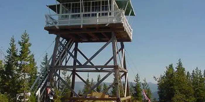
Arid Peak Lookout was built in 1934 to help detect fires that may have been sparked by the Milwaukee Railroad Line. It was last staffed in 1969 and sat idle for over 25 years before being renovated by a team of over 30 volunteers, the Forest Fire Lookout Association and the U.S. Forest Service. Arid Peak Lookout was restored to its original splendor in 1997 and is available for rent to the public. The lookout is listed on the National Register of Historic Lookouts and provides epic 360 degree views of the Bitterroot Mountains. Access to the cabin requires a moderately-steep 3 mile hike and availability is dependent on weather conditions.
Recreation
The Hiawatha Bicycle Trail is considered the "crown jewel" of rail-to-trail mountain biking trails as it zips across seven trestles and through 10 tunnels in the magnificent Bitterroot Mountains. The trail can be accessed just over 10 miles from the lookout. The lookout offers access to the Arid Peak Trail #173, Mozier Peak Trail #174, and Kyle Creek Trail #175. All three trails are great for day-hiking, but can also be explored over longer backpacking treks or on horseback.
Facilities
The cabin fits up to four guests. Furnishings include two cots with mattresses, basic cooking gear, dishes, a propane lantern, propane camp stove, water containers, a table with two chairs and a wood stove. Anouthouse is located outside the tower.No water is available so guests must bring their own or boil and treat stream water. Propane canisters are not included; a stock of 16.4 ounce canisters are required to use cooking and lighting equipment. Other items to pack include bedding, food, binoculars, a first aid kit, flashlights, towels, toilet paper, and dish soap.
Natural Features
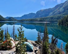
The Arid Peak Lookout is located within the St. Joe River area of the Idaho Panhandle National Forests, an area that includes most of what was originally established as the St. Joe National Forest. The area is known for its blue-ribbon cutthroat trout streams, Wild and Scenic Rivers and extensive roadless and primitive areas. The St. Joe Rover area is also nationally recognized for its elk herds. The 20 foot tower sits at an elevation of 5,306 feet and overlooks the beautiful Loop Creek area and the scenic Hiawatha Bicycle Trail. The mixed conifer forest around the facility includes Douglas fir and spruce. Wildlife sightings of elk, deer, black bears, moose and bald eagles are common. This is bear country; Visitors are advised to be aware of and practice bear safety.
Contact Info
For facility specific information, please call (208) 245-2531.
Nearby Attractions
The town of Avery has the nearest conveniences.
RV Road Trip Guides

Map & DirectionsArid Peak Lookout is located in Idaho near Avery
Directions
From Avery, turn left and head north up the North Fork of the St. Joe River Road #456 toward Wallace. Travel about 4.5 miles, then turn left down the hill just before the bridge across the river. You will then be on Road #1997, which is a single lane gravel road with pull outs. Drive about 3.5 miles and turn left on the first road (also labeled Road No. 1997). Travel 6.5 miles to Trailhead #175. A turn-around is just past the trailhead before the gate. Do not block the turnaround or the gate. Park in the wide spot by the trailhead. Hike up Trail #175 for 1.5 miles to the junction with Trail #173. Turn right and hike 1.5 miles on Trail #173 to Arid Peak.
Address
34 HOYT DRIVE HC BOX 1
Avery, ID 83802
Coordinates
47.3588889 N
115.7652778 W
Connectivity
 T-MobileNo Coverage
- VerizonNo Coverage
- AT&TNo Coverage
Connectivity
- T-MobileNo Coverage
- VerizonNo Coverage
- AT&TNo Coverage
Access
- Drive-InPark next to your site
- Hike-InBackcountry sites.
Site Types
- Cabins
Features
For Campers
- Reservable
Drive Time
- 1 hr 34 min from Coeur d'Alene, ID
- 2 hrs 3 min from Spokane, WA
- 2 hrs 6 min from Missoula, MT
- 3 hrs 21 min from Lewiston, ID

