Boat-in access defines this Forest Service cabin rental, requiring watercraft to reach the forested site along Fish Creek within Tongass National Forest. The $65 nightly rate includes cabin accommodations but prohibits pets and RV camping entirely. Anglers find creek and lake fishing opportunities directly accessible from the property.
Reservations help secure this remote spot, though campers should prepare for the logistics of boat-based supply transport. For additional waterfront options, consider Alava Bay Cabin to the south.
Description
Overview
Fish Creek Cabin is located on Revillagigedo Island, at the confluence of freshwater Fish Creek and saltwater Thorne Arm. The rustic, secluded retreat is available year-round for relaxation, sightseeing and recreation. The site can be accessed by float plane, boat or kayak, depending on conditions. Guests are responsible for their own travel arrangements and safety, and must bring several of their own amenities.
Recreation
Crabbing is possible for Dungeness crab, and saltwater fishing is available for salmon, halibut and rockfish. Fish Creek offers opportunities for freshwater fishing for cutthroat and rainbow trout, steelhead and Dolly Varden.Hikers can access two trails from the cabin. The Low Lake Trail leads to Big Lake in Misty Fjords National Monument wilderness, following along Low Lake and Fish Creek on the way. Gokachin Lake Trail starts across the outlet of Fish Creek and leads to Star Lake.Sea kayaking is an extremely popular way of getting around, but guests must provide their own equipment and consult local tide tables before setting out.
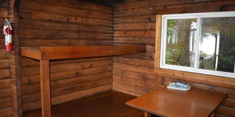
Facilities
This 12-by-14 cabin (pan-abode style) has two single and two double bunks, to accommodate up to six people. It is also equipped with a table and benches, broom, a small wood stove and an outhouse. A mooring float is available, but it is not for the exclusive use of cabin guests.Water, wood, and electricity are not provided. Guests must bring wood or biobricks for the wood stove. Biobricks can be purchased in Ketchikan and on Prince of Wales. The stove is not designed for use with wax logs such as duraflame. Water is available from the creek, but guests should be sure to treat water before drinking or cooking with it (water safety tips). It is recommended that guests bring their own water supply.Other items to pack include sleeping bags, sleeping pads, lanterns or flashlights, cookware, plates, utensils, food, toilet paper, garbage bags, a fire extinguisher and matches, among other necessities. Guests are expected to pack out trash and clean the cabin before leaving (click here for more cabin details).
Natural Features
The cabin is tucked into a densely wooded area overlooking Thorne Arm. Fish Creek bubbles into Thorne Arm on the left side of the cabin. A gravel beach is revealed at the front of the cabin during low tides. Sitka black-tailed deer, black bear, beaver, marten, and mink are common to the area (bear safety information). Seals and orcas have been seen in Thorne Arm.
Fee Info
Only one change per reservation for all Alaska cabins is allowed. Change is defined as a modification to the start or end date of the reservation; after one change has been made, if additional changes are desired, the customer must cancel the current reservation and re-book the new dates.
Map & DirectionsFish Creek Cabin is located in Alaska near Ketchikan
Directions
The cabin is located approximately 20 air miles from Ketchikan, at the North end of Thorne Arm. Accessible by float plane or boat. A saltwater mooring buoy is available on a first-come, first-served basis. Refer to USGS topographic map for Ketchikan B-4, and check local tide tables if navigating a boat or kayak in saltwater.
Coordinates
55.3914 N
131.1977 W
Connectivity
 T-MobileNo Coverage
- VerizonNo Coverage
- AT&TNo Coverage
Connectivity
- T-MobileNo Coverage
- VerizonNo Coverage
- AT&TNo Coverage
Access
- Boat-InSites accessible by watercraft.
Site Types
- Cabins
Features
For Campers
- Reservable

