


Free Camping Collection
Established Camping
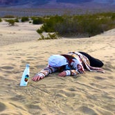
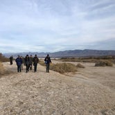
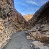
Breakfast Canyon - Secret Ranger Campground — Death Valley National Park

About
National Park Service
Breakfast Canyon is in the Valleys category for Inyo County in the state of California. Breakfast Canyon is displayed on the Furnace Creek USGS quad topo map. Anyone who is interested in visiting Breakfast Canyon can print the free topographic map and street map using the link above. The latitude and longitude coordinates of Breakfast Canyon are 36.4399486, -116.8500524 and the approximate elevation is -30 feet (-9 meters) above sea level. If you have visited Breakfast Canyon before, please tell us about it with a comment below.
Location
Breakfast Canyon - Secret Ranger Campground — Death Valley National Park is located in California
Coordinates
36.4399486 N
116.8500524 W
Access
Stay Connected
- WiFiUnknown
- VerizonAvailable
- AT&TUnknown
- T-MobileUnknown
Site Types
- Tent Sites
- Standard (Tent/RV)
- Equestrian
Features
For Campers
- Picnic Table

 Legend
Secret Ranger Campground
This is a private canyon that is only used by the park rangers and morning horse rides. Hence its name. It is blocked off by a gate but it can be accessed if you help with the Christmas Audubon bird count over the holidays.
There is a pit toilet and picnic areas with a flat ground area for tents. Not much flat parking space for RV’s and campervans though. There are also two fireplace areas and grills for cooking.
- (5) View All