


Established Camping
Turlo Campground
About
National Forest
Mt. Baker-Snoqualmie National Forest
Overview
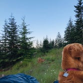
Turlo Campground is located just off the Mountain Loop Highway in the Mt.Baker-Snoqualmie National Forest. The campground is nestled in tall firs, cedars and hemlocks, adjacent to the south fork of the Stillaguamish River. The location offers individuals and families a tranquil camping experience with plenty of opportunities to fish, enjoy the river or relax at their campsite.
Recreation
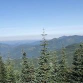
The Mt. Baker-Snoqualmie National Forest has 1,500 miles of trails, ranging from smooth paths through deep, quiet forests to challenging ascents up boulder-studded mountains. Hiking opportunities abound for every skill level. The Mt. Dickerman Trail, close to the campground, switchbacks steeply for 3 miles through a dark forest to an alpine meadow, which was replanted in 1915 after a major forest fire. From this point, the trail rises above the timberline to an alpine meadow alive with masses of wildflowers in July and August. The trail is generally in good condition, and spectacular views can be seen from all directions as the trail climbs to the 5,723 foot summit.
Facilities
Turlo Campground offers standard sites, accommodating both tent and RV camping. Picnic tables, flush toilets and drinking water are also available, however there are no electrical hook-ups. Access to the Stillaguamish River is available from the campground.
Natural Features
Situated on the west side of the Cascades between the Canadian border and Mt. Rainier National Park, Mt. Baker-Snoqualmie National Forest is one of the most spectacular in the the country, showcasing glacier-covered peaks, wide mountain meadows and old-growth forests, rich in history and outdoor opportunities. On a clear day, visitors will see Mt. Baker, the most prominent feature of the Mt. Baker Wilderness Area. Rising to an elevation of 10,781 feet, the active volcano from which the forest takes its name, is perpetually snow-capped and mantled with an extensive network of creeping glaciers. Mt. Baker's summit, Grant Peak, is actually a 1,300-foot-deep mound of ice, which hides a massive volcanic crater. Old-growth forests line the wide, gently-flowing river, known for its salmon run. Salmon and other species including, chinook, coho, chum, pink, and sockeye salmon, steelhead trout, sea-run cutthroat, and bull trout, use the Stillaguamish and its tributaries for spawning.
contact_info
For facility specific information, please call (530) 932-0242.
Nearby Attractions
Visit or stay in one of the historic lookouts in the area. Lookouts are tangible symbols of Forest Service heritage, perched on high peaks with unobstructed views where they have been used throughout the years to detect and control fires in remote wildlands. Take some time to visit nearby Mount Rainer National Park. Considered a wonderland, the park offers a fantasic glimpse into glaciers, subalpine ecology, and volcanic landscapes typical in the region. Discover the Verlot Public Service Center, near the South Fork Stillaguamish River. Built by the Civilian Conservation Corps from 1933 to 1942, Verlot`s handsome buildings reflect the architectural style and fine craftsmanship of that era and are listed on the National Register of Historic Places.
Charges & Cancellations
Once your reservation start date has begun, neither the Recreation.gov Contact Center nor the campground manager will be able to modify your reservation.
Access
- Drive-InPark next to your site
- Walk-InPark in a lot, walk to your site.
Stay Connected
- WiFiUnknown
- VerizonUnknown
- AT&TUnknown
- T-MobileUnknown
Site Types
- Tent Sites
- RV Sites
- Standard (Tent/RV)
Features
For Campers
- Trash
- Picnic Table
- Firewood Available
- Drinking Water
- Toilets
- Alcohol
- Pets
- Fires
For Vehicles
- Sanitary Dump
- Big Rig Friendly

 Traveler
One of the best!
It’s one of the first you run into in the national forest, so super easy to get to. The campground itself is fairly small, but the sites are pretty spacious and private. A number of them have paths to the river, but if you don’t have one of these sites it can be kind of awkward to get down there. But the river is always beautiful and the campground is always clean. Would definitely recommend.

 Scout
ScoutClosed!
I came all the way from Los Angeles to enjoy Washington and nearly every campground is closed. It's a perfectly nice sunny day, it's a shame people need a minder to be able to enjoy nature.

 Ranger
Baker-Sno
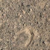
Great place to escape everyday life and retreat to the woods. Turn off i90 and head straight into your campsite, where you can pop up your tent and watch the sun set. This place is very simple, nothing extra special but it’s got the necessities. Some interesting tracks caught my eye as I was talking a walk near my campsite. Pretty cool, huh?!
- (4) View All
Location
Turlo Campground is located in Washington
Directions
From Seattle, Washington: Go north on I-5 to Everett. Take exit 194 onto Hwy 2. Head north at Hwy 204, toward Lake Stevens. Turn north on Hwy 9, then east on Hwy 92 to Granite Falls.
Coordinates
48.0955556 N
121.7902778 W