
Established Camping
Tellico River Area
About
USDA Forest Service
View of Bald River Falls in Cherokee National Forests This area provides outstanding opportunities for fishing, camping, hiking, and scenic driving. It is also home to the popular Indian Boundary Recreation Area and the Cherohala Skyway. Nearly 30,000 acres of remote backcountry surround three rivers and their tributaries, where fishing for brown, rainbow and brook trout is excellent. Cherohala Skyway (TN 165/NC143), a 43-mile National Scenic Byway, winds between Tellico Plains, Tenn. and Robbinsville, N.C. Tellico River Road (FR 210) offers intimate views of the river and 90-foot Bald River Falls. Spend the night at the historic Donley Cabin and check out CCC structures at Tellico Ranger Station and Dam Creek Picnic Area. Hike across the area on the Benton MacKaye Trail. Camp at sites along Tellico River or in Indian Boundary Recreation Area just off Cherohala Skyway. Tellico River Area Map Tellico River Area Guide
Access
Stay Connected
- WiFiUnknown
- VerizonUnknown
- AT&TUnknown
- T-MobileUnknown
Site Types
- Tent Sites
Features
For Campers
- Picnic Table
- Toilets

 Traveler
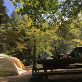
Sweet Spot by the River
Nice spot by the creek. Beware of bear hunting season - hunters driving by with baying hounds at all hours of the night. Didn't help that we got the spot right by the road. Still a nice spot, definitely were a few permanent residents at the site with tied-out dogs and schoolbuses and such...
Location
Tellico River Area is located in Tennessee
Coordinates
35.32007064 N
84.14453836 W