


Established Camping
South Fork Campground
About
USDA Forest Service
Mendocino National Forest
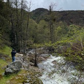
Located on the South Fork of Stony Creek. Two large areas available for open camping.
Access
- Drive-InPark next to your site
Stay Connected
- WiFiUnknown
- VerizonUnknown
- AT&TUnknown
- T-MobileUnknown
Site Types
- Tent Sites
- RV Sites
Features
For Campers
- Trash
- Picnic Table
- Phone Service
- Reservable
- Drinking Water
- Toilets
- Alcohol
- Pets
- Fires

 Traveler
Spectacular off the grid weekend
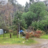
A pretty primitive place only 10 or so sites to camp. Tent only as the road to get here at the end you need high clearance vehicle. Although there was a Tesla and other cars that made it up remarkably!! The river is flowing real good. There are 2 trailheads in the area. It rained some while we were there so we didn’t venture too far out. There is a primitive toilet that was pleasing to see. A small building with a hole in the ground but better than nothing. I wished I had brought a rod and reel and license to fish. Next time!!
- (6) View All

 Guide
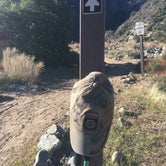
GuideAngeles National Forest
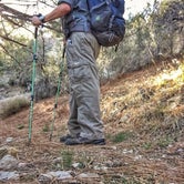
There is an alternate trail of the Pacific Crest Trail (PCT) running right thru this campground. In the soring there is snow run-off just to the west of the campground. You can drive in from the north, or backpack in from the Devil’s Punchbowl (about 7 miles west). The hike has a serious Canyon that will kick your butt...28% - 34% grade coming out of it, so make sure you’re in halfway good shape if you hike in.
Get a permit at area gas stations back in Pearblossom...parking is $5 a day. Camping is rustic at best. But the people camping there all want to get away from humanity...you’ll know when you get there that this is a no-frills site with those that want privacy.
if you love hiking and want privacy, this is your camp! Bring all your supplies because it’s a hassle to drive out for things you forget.
- (7) View All
Location
South Fork Campground is located in California
Directions
In Stonyford, CA, at the intersection of Fouts Springs Rd. and Lodogo-Stonyford Rd., take Fouts Springs Rd. (Forest Service Rt. M10) west 8.3 miles to Fouts Springs OHV Staging Area sign. Turn right at sign and go 0.2 miles to campground on right.
Coordinates
39.36150747 N
122.6535904 W