


Free Camping Collection
Established Camping
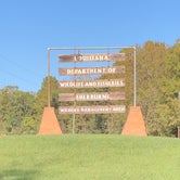
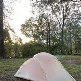
Richard K. Yancy Sand Levee Campground

About
Fish and Wildlife Service
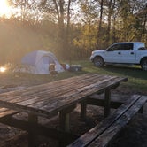
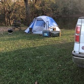
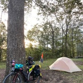
Camping: LDWF maintains five primitive camping areas on Richard K. Yancey WMA. There are all-weather access roads as well as a source of potable water at the Shell Road camping area.
Richard K. Yancey WMA lies between the Mississippi and Red rivers, beginning north of Lower Old River. The WMA’s terrain is typically flat to depressed; the only significant changes in relief are elevated roads, levees, and a large manmade sand ridge. Numerous small lakes and bayous are formed by the area’s relatively poor drainage pattern. A large portion of the land is subject to annual spring flooding by the Red and Mississippi rivers.
Timber on the property consists of mixed bottomland hardwoods. The primary overstory species are bitter and sweet pecan, overcup and nuttall oak, bald cypress, honey locust, hackberry, sycamore, and green ash. There are almost pure stands of cottonwood and willow along the manmade sand ridge.
LDWF has planted approximately 265,000 hardwood seedlings on about 800 acres of former agricultural lands and annually maintains abandoned oil well sites and rights-of-way as wildlife openings.
Access
- Drive-InPark next to your site
- Walk-InPark in a lot, walk to your site.
Stay Connected
- WiFiUnknown
- VerizonUnknown
- AT&TUnknown
- T-MobileUnknown
Site Types
- Tent Sites
- Standard (Tent/RV)
- Group
Features
For Campers
- ADA Access
- Phone Service
- Alcohol
- Pets
- Fires

 Ranger
Nice place
Went on a short hunting trip in November. Was quiet except for the rifle range but knew that coming in. Had a few visitors (racoons, possums and armadillos) but they didn’t bother me. Enjoyed the trip
- (13) View All
 Ranger
Primitive site, no one around
We slept great here in our tent. Some things to consider: lots of trash left around the area, there was a fire still burning unattended when we arrived, car/truck/tractor/boat traffic is noisy at all hours of the day and night, no water for drinking unless you can dip and filter from the creek nearby, the mosquitoes here were insane!

 Guide
GuideGreat wma campsite
Nice nature feel to the campgroud..its primitive but does offer potable water for cleaning equipment and such..had a great time camping here

Location
Richard K. Yancy Sand Levee Campground is located in Louisiana
Directions
Richard K. Yancey WMA is located about 35 miles south of Ferriday on LA Hwy 15. LA Hwy 15 and 910 and a gravel levee provide all-weather access to the WMA. Gravel roads and numerous woods roads traverse the interior. You can also access the WMA by boat along the Red River and the numerous bayous that flow through the area.
Coordinates
31.002 N
91.659 W