
Established Camping
Sugar Creek Campground and Day Use Area
About
National Forest
Ochoco National Forest and Crooked River National Grassland
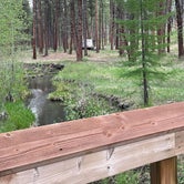
Sugar Creek Campground and Day Use Area are among the most highly developed recreational sites on the Ochoco National Forest. __The campground offers three moderately accessible campsites and all pathways are ADA compliant. __The setting of the facility is a young ponderosa pine forest, straddling a creek with easy access to a paved Forest Service Road. Opportunities for picnicking with a large group exist in the Day Use Area. __Additionally, a short hike and wildlife viewing along Sugar Creek Trail are available throughout the facility.Come take a break from civilization and enjoy the fresh pine scented air at Paulina Ranger District's most desirable campground!View a map of Sugar Creek Campground and Day Use Area.
Access
- Drive-InPark next to your site
Stay Connected
- WiFiUnknown
- VerizonUnknown
- AT&TUnknown
- T-MobileUnknown
Site Types
- Tent Sites
- RV Sites
- Standard (Tent/RV)
Features
For Campers
- Drinking Water
- Toilets
- Alcohol
 Guide
GuideAnother shady pine tree camp
Large campground with few people in Mid May. Quiet well spaced sites with tables and fire pits. Even had a enough sun through the trees to solar charge.
Clean campground, potable water, pit toilets, paved walking paths around creek and campground.
Great place to stay a couple of days and hike Black Canyon Wilderness.
Location
Sugar Creek Campground and Day Use Area is located in Oregon
Directions
From Prineville, Oregon:Take Post-Paulina Hwy (State Highway 380) southeast from Prineville for about __55 miles, then turn left onto Izee Hwy east of Paulina (County Road 112).__Travel on County Road 112 for 3.5 miles to Beaver Creek Road (County Road 113).__Turn onto the left fork (County Road 113) and go 7.5 miles to Forest Service Road 58.Follow Forest Service Road 58 for 2.25 miles to Sugar Creek Campground.Sugar Creek Campground is about 12 miles from the community of Paulina and near Rager Ranger Station, which is no longer operational.
Coordinates
44.234305 N
119.804511 W