


Established Camping
Toiyabe National Forest Toquima Cave Campground
About
National Forest
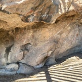
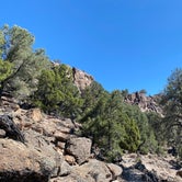
The big attraction here is, of course, the caves. The half-mile Cave trail begins in the campground, with a series of stone steps leading to the rock shelter site. The red, yellow, black and white images (pictographs) here were painted by ancient Shoshones. Projectile points found at this cave date to about 600-1300 CE. On nearby BLM land is Spencers Hot Springs. The water is 192 degrees, and there is a developed tub and a below-ground pool. 2 units NO group.
Access
- Drive-InPark next to your site
- Walk-InPark in a lot, walk to your site.
- Hike-InBackcountry sites.
Stay Connected
- WiFiUnknown
- VerizonUnknown
- AT&TUnknown
- T-MobileUnknown
Site Types
- Tent Sites
- RV Sites
- Standard (Tent/RV)
Features
For Campers
- Trash
- Picnic Table
- Toilets
- Alcohol

 Legend
Dry and Hot
Perfectly nice campground with all the expected amenities. Pit toilets, fire pits and tables. My issue is it is placed on a hill to be close to the cave but no water source nearby and just kind of dry, hot and dusty.
- (5) View All

 Ranger
Nice campground way up there
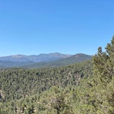
Great national forest campground way up a long dirt forest road. Elevation like 7,000, so cooler. Various size sites with fire pits and picnic tables. Lots of trees provide privacy and wind screen too. Centrally located pit toilets.
Campground is at the trailhead of a short hike to the Toquima Cave, which is well worth the walk even though the mouth of the cave is fenced off. You can still clearly see the amazing artwork on the cave walls. Beware of rattlesnakes. We ran into one right on the trail near the cave.
Note there are also many free dispersed camping sites on this road up to and after the campground, plus all the dispersed sites at Spencer’s Hot Springs down below near the head of the forest road.
Location
Toiyabe National Forest Toquima Cave Campground is located in Nevada
Directions
from Tonopah, Follow US 6 east from Tonopah to the State Road 376 junction. Turn left and continue north for approximately 100 miles to the Nevada State shaped sign, about 0.1 mile south of the US 50 and State Road 376 junction. Turn right onto this road and continue approximately 12 miles to the campground.
Coordinates
39.18770091 N
116.7905 W