


Established Camping
Big Bend of the Colorado State Recreation Area

About
State Park
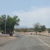
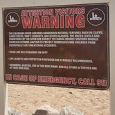
Situated on the shores of the Colorado River at Nevada’s southern tip, Big Bend of the Colorado River includes about two miles of sandy shoreline. Because the park is downstream from Davis Dam, the river is clear and cool year round. Popular activities are camping, picnicking, boating, fishing, swimming, hiking and bird watching. The variety of waterfowl and shore birds that make this park home include mallards, coots, herons and geese. Hawks, roadrunners, quail, hummingbirds, doves and owls are also abundant in the park. The nearby town of Laughlin offers the amenities of a Nevada gaming town.
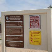
Big Bend boasts a 24-unit campground that is accesible year-round. All sites are on a first come, first served basis, reservations are not available. All sites are designed to accommodate RVs with hook-ups for water, electric and sewer. In addition, most of the sites have pull-through parking pads that can accommodate any size RV. The sites also have a tent pad, a shade ramada, barbecue grill and fire pit. Three of the sites are ADA equipped and available for those visitors with the proper ADA permit. Other amenities include restroom and shower facilities. Camping is limited to 14 days in a 30-day period.
Access
- Drive-InPark next to your site
- Walk-InPark in a lot, walk to your site.
- Boat-InSites accessible by watercraft.
Stay Connected
- WiFiAvailable
- VerizonAvailable
- AT&TGood
- T-MobileAvailable
Site Types
- Tent Sites
- RV Sites
- Standard (Tent/RV)
- Group
- Tent Cabin
Features
For Campers
- ADA Access
- Trash
- Picnic Table
- Firewood Available
- Phone Service
- WiFi
- Showers
- Drinking Water
- Electric Hookups
- Toilets
- Alcohol
- Pets
- Fires
For Vehicles
- Sanitary Dump
- Sewer Hookups
- Water Hookups
- Big Rig Friendly

 Legend
Beach and regular campsite open
Visited today and seen the primitive camping area (no hookups) was currently closed. The regular campsites with full hookups was open. Maybe with weather, and less campers is the reason for closing the overflow/primitive side. Only 1 RV today and all the other sites open. Beach was crowded on both sides. Was still able to get a spot on the water and set up canopy. Still favorite spot in Laughlin/Bullhead City area.
- (20) View All

 Guide
GuideBeautilful
Did not camp, only came for one day. But did take driving tour through the campsite. Only saw 3-4 RV’s. Maybe bc we came mid July at it was over 110 F! The river was cold but once in you acclimate. Did some snorkeling. Beautiful sandy spots. Just dont understand with all the space why some people decide to come squeeze in between you and others on the shore. Other than that had a great time. Will come again and maybe camp!

- (8) View All
LegendLarge campsites and close to the river
Stayed here in March for 3 nights. This place was my first choice to stay, as I been here plenty of times before but never camped here. Its FCFS and the sites are usually full or nearly full. Mostly with the snowbirds during the winter months. The sites are fairly large and spaced out. They were working on extending the campgrounds to make more campsites when I stayed. This place has full hookups, which was extremely nice with a family of 3. They did have water and dumpsite near the entrance. You are a 3 minute drive to the beach/river area. The beach is nice and well maintained. There are two sides to jump into the water. There are walking trails that needed to be maintained, but this was only because there was a fire in the area some time ago. Camp host and ranger station were great and assisted with anything needed. I just wish they took reservations, as this is my favorite spot to camp in Laughlin area. Davis Dam campgrounds and Avi don't have anything on this place. Go to Avi if you want cramped, parking lot camping, or Davis if you want run down facilities. The restrooms were the cleanest I seen in a state and/or national park. Will return!
Location
Big Bend of the Colorado State Recreation Area is located in Nevada
Directions
The park is within the Laughlin town limits, one mile south of Casino Drive on South Needles Highway.
Coordinates
34.76605556920265 N
114.77418947339142 W