


Established Camping
Oak Fork
Warning 3 Alerts are In Effect
There are 3 alerts for this campground. Camp safely!
Warning 3 Alerts are In Effect
There are 3 alerts for this campground. Camp safely!
<strong>Timothy Lake is currently only accessible from the east (Hwy 26) due to the 2020 wildfires.</strong> Please see the <a href="https://www.fs.usda.gov/alerts/mthood/alerts-notices/?aid=75379" rel="nofollow">Forest Service closure orders and map</a> for more information.Please see <strong>"Facility Information / Getting Here" for recommended route.</strong>
<strong>NOTICE</strong>: In response to customer feedback, we have established generator hours. Effective in 2024, <strong>generator use is allowed only from 8 am to 8 pm</strong>. It is prohibited to operate generators or idle engines between 8 pm and 8 am.
<strong>Timothy Lake is currently only accessible from the east (Hwy 26) due to the 2020 wildfires.</strong> Please see the <a href="https://www.fs.usda.gov/alerts/mthood/alerts-notices/?aid=75379" rel="nofollow">Forest Service closure orders and map</a> for more information.Please see <strong>"Facility Information / Getting Here" for recommended route.</strong>
About
Utility Company
Mt. Hood National Forest
Overview
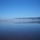
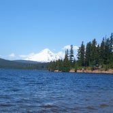
Oak Fork Campground is located on the shores of Timothy Lake in the shadow of Oregon's Mt. Hood. The surrounding forest setting offers spectacular views, miles of trails for exploration and abundant fishing.
Recreation
Proximity to Timothy Lake allows campers to enjoy a variety of water-related recreation activities, including boating and sailing, as well as swimming, windsurfing and fishing. Anglers can expect a catch of kokanee salmon and a variety of trout . A range of trails are located in the area. The Timothy Lake Trail is popular for hiking, mountain biking and horseback riding. The 12 miles of relatively level terrain loops trekkers around the lake, providing scenic views of the area. It connects to the Pacific Crest National Scenic Trail, a lengthy hike that extends across three states, from the borders of Canada and Mexico. Portions of that trail also lead southwest to Clackamas Lake Campground. The Clackamas Lake Ranger Station Historic District is less than 2 miles from the campground. It was built to house forest service workers in the early 1900s. The rustic architecture and historic nature of the buildings and the surrounding area draws thousands of tourists each year.
Facilities
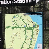
The campground offers 36 single-family campsites, six cabins, and eight hike-to sites with some of these as accessible sites. Each site is equipped with a picnic table and fire grill. Accessible vault toilets and drinking water are provided. An on-site host is available for questions regarding the campground and surrounding area.Sleeping cabins are furnished with a twin over twin bunk, a twin over full bunk, a table and two chairs. The beds have mattresses, but please bring your own bedding. Cooking and smoking in cabins is prohibited and pets are not allowed in the cabins or at the cabin sites. Cabins are nonelectric.__ The nearest gas station/convenience store is about 18 miles away, west on Hwy. 26. The nearest grocery store is in Government Camp, about 23 miles away, west on Hwy. 26.
Natural Features
The campground is situated on the southeastern shore of the roughly 1,400-acre lake, at an elevation of 3,400 feet. Timothy Lake was created in 1956 as a storage reservoir for the Oak Grove Hydroelectric Project. It is one of the larger lakes in the Mt. Hood National Forest.
Nearby Attractions
Oak Fork is about 27 miles from the base of majestic Mt. Hood, the highest point in Oregon. The historic Timberline Lodge in Government Camp offers scenic views of the snow-capped mountain.
contact_info
Between 05/26/2023 and 09/09/2023 this location is staffed. Please call (503) 834-2215 to speak with local staff. From 11/22/2022 to 05/25/2023 this location is unstaffed. Please call (503) 464-8515 for general information.
Charges & Cancellations
A service fee will apply if you change or cancel your reservation. Late cancellations are subject to additional fees. For full details see the Recreation.Gov, Rules & Reservation Policies.
Fee Info
Payment in-full will be charged to your credit card upon completion of the reservation. A non-refundable online reservation fee may be charged for some facilities.
Access
- Drive-InPark next to your site
- Walk-InPark in a lot, walk to your site.
- Hike-InBackcountry sites.
Stay Connected
- WiFiUnknown
- VerizonUnknown
- AT&TUnknown
- T-MobileUnknown
Site Types
- Tent Sites
- RV Sites
- Standard (Tent/RV)
- Cabins
Features
For Campers
- Trash
- Picnic Table
- Firewood Available
- Drinking Water
- Toilets
- Alcohol
- Pets
- Fires
For Vehicles
- Big Rig Friendly

 Guide
GuideNice campground on Timothy Lake
This is one of several great PGE-run campgrounds on the south side of Timothy Lake. We stayed here Memorial Day weekend, and it was still fairly cold, with some snow on the ground. Reservations were full, but we were lucky and found a first come first serve spot. I would pick Hoodview over this campground, since it was recently renovated, but in the end this area is so beautiful you cannot go wrong with any of the PGE campgrounds.
 Scout
ScoutRacist rangers
Recently stood at Oak Forest Campground only to question coming back there ever again park hosts are very mean to people of color purposely walks awayfrom certain people and makes up rules as he goes . sad thing is we are just trying to have a good family camping tripand this ranger felt the need to downtalk us or constantly tell us rules . Smh
 Guide
GuideGorgeous!
The campground is ran by PGE. Camp host is super nice. Bathroom is very clean. Timothy Lake is Gorgeous! There’s even cabins to stay in!
Location
Oak Fork is located in Oregon
Directions
From Sandy, Oregon, travel east on Highway 26 for approximately 40 miles to Skyline Road/Road 42. Turn right on Skyline Road and continue south for about 9 miles. Turn right on Forest Service Road 57,and then turn right again at the Oak Fork Campground entrance sign.
Address
OAK FORK CAMPGROUND
SKYLINE ROAD
Timothy lake, OR
Coordinates
45.115 N
121.770833 W