


Established Camping
Poverty Flat
About
National Forest
Payette National Forest
Overview
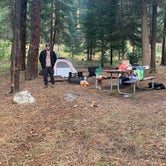
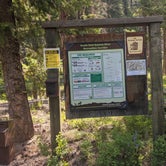
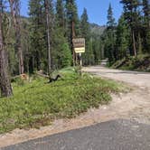
Located along side the South Fork Salmon River, this paved campground offers 10 campsites, including 4 walk in tent sites.__ This location is available on a first-come, first-served basis only. Visitors are required to physically arrive at the campground to purchase and claim a site. Once on-site, you may be able to pay for your campsite(s) by scanning a QR code using the Recreation.gov mobile app, and the Scan and Pay feature.__ If this option is available, you will need to first download the free Recreation.gov mobile app https://www.recreation.gov/mobile-app prior to your arrival as some remote areas have limited or no cellular service.
Recreation
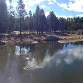
__The campground serves as take-out for those floating the South Fork of the Salmon River from Goat Creek. Serves as the trailhead for an extensive trail system. Many loop hikes are possible from here, of varying lengths and difficulties. Open to those on foot, horses, mountain bikes, and trail bikes. Fishing in the river.__
Facilities
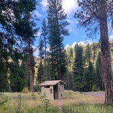
Fire rings, hitching rails, toilet, drinking water, pack in/pack out. Please pack out all your trash. No hook-ups.
Nearby Attractions
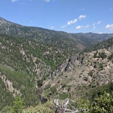
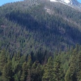
The South Fork of the Salmon River is a highly popular area of the Forest and is one of the earlier areas to be snow-free in the spring. Several campgrounds and dispersed campsites can be found along the South Fork Road (FS Rd #674). The southern-most 7 miles of the South Fork Road are on the Boise National Forest.
Access
- Drive-InPark next to your site
- Walk-InPark in a lot, walk to your site.
Stay Connected
- WiFiUnknown
- VerizonUnknown
- AT&TUnknown
- T-MobileUnknown
Site Types
- Tent Sites
- RV Sites
- Standard (Tent/RV)
- Group
Features
For Campers
- Drinking Water
- Toilets
- Alcohol
- Pets

 Traveler
Underused Gem
I first found out about poverty flats when I was checking out a near by hot spring, Mile 16. I decided to camp here so I could be close by to the spring. The camp ground had about 4 spots being used when I first came. The next day it was us and another couple. There’s a water spigot, and a outhouse. The outhouse hasn’t been maintained much, and was out of toilet paper. The spot is right off the main forest road, so I could hear the occasional car driving by. Other than those two things I really enjoyed our stay. It’s a short walk, or shorter drive, to one of my favorite hot springs in the state. I definitely would recommend poverty flats. It’s a great campsite in the middle of nowhere idaho.
- (4) View All

 Legend
Very peaceful!
I really liked how nice this campground was. Some of the sites you can drive into while others you walk a short ways in. There is access to the river and a hike right from this historical campground. The South Fork of the Salmon River runs right next to the campground. There is water at the front of the campground next to the fee area. There is a pit toilet right in the middle of the campground.
- (4) View All

 Guide
GuideA scenic drive and a great campground.
I make sure to visit this campground every year. The drive out is amazing, and there are plenty of hot springs along the way. There is dispersed camping, and the campground itself feels more primitive than others just because of how far out of the way you are.


- (8) View All
Location
Poverty Flat is located in Idaho
Directions
From McCall, go 30 miles northeast on Forest Road 48 (Lick Creek Road), then 13 miles south on FR 674 (South Fork Road). The South Fork corridor is about 30 miles from Cascade along the Warm Lake Highway. Usually by July, Lick Creek Pass (Road #48) is snow-free, providing a faster access from McCall (35 miles) to the South Fork corridor. Please follow posted speed limits and drive carefully, the South Fork Road is a paved, narrow, one-lane road with two-way traffic and many blind corners.
Coordinates
44.824672 N
115.702442 W