


Established Camping
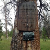
China Meadows Trailhead
About
USDA Forest Service
USGS Quad - Bridger Lake and Gilbert Peak; Leashed pets are permitted. This area is popular for its fishing and hiking, it is close to wilderness access.
Access
Stay Connected
- WiFiUnknown
- VerizonUnknown
- AT&TUnknown
- T-MobileUnknown
Site Types
- Tent Sites
Features

 Legend
Ranger Review: Nature's Coffee Kettle @ China Meadows Trailhead
Campground Review:
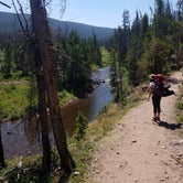
I have been backpacking 4 times in the Uintas and have climbed Kings Peak (Utah's tallest mountain) twice, but this place was by far my favorite and most picturesque visit! On the way to the trail head you pass Stateline, Bridger Lake, Marsh Lake, and China Meadows Campgrounds respectively, so if you don't want to backpack then these are some great options in the area that allow you to day hike the trailhead instead. At each one of the campgrounds there is also great fishing with Stateline Reservoir being the largest (and busiest!) Fees for the trailhead are $3 a day and they only accept cash or check.
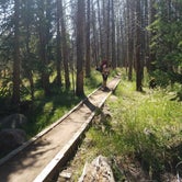
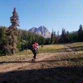
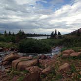
Now for the back country dispersed camping you came here for! There are numerous places to camp along the trail just remember to follow the minimum distance rules from trails and water bodies so you can help make others' trips as serene as yours. The first popular spot to stop on the trail head occurs after a few miles in at a fork east that takes you to Lake Hessie. Round trip to the lake and back is around 7 miles. Beyond this intersection you pass through a tunnel of trees until you get to one of the only truly steep spots on the trail, a series of 5 switchbacks that gain a couple hundred feet of elevation. After these you get your first good look at the immense Red Castle in the distance! Not too far past the switchbacks is another intersection followed by Lower Red Castle Lake where most people stop to camp. There are 2 trails in this area: the lower trail will take you down to the lake but is very muddy and almost impassible during early spring. It is better to take the upper trail that continues to the main lake and then backtrack from the south end of the lake. Getting here puts you about 9 miles into the back country.
Where we decided to stop was at a small unnamed lake about a mile below Main Red Castle Lake. If you want to stop here it is the only lake that the trail passes right next to (I mean literally right next to it) We really loved camping here as we were able to fish for Tiger and Cutthroat trout extremely close to our campsite! It also has amazing views of Red Castle at sunset. While we were up there we only had neighbors the first night and the next 2 nights we had the lake all to ourselves! It takes a lot of effort to get up there but the solitude is absolutely worth it! From this base camp we were able to explore the Main Lake and Upper lake of Red Castle. If you've ever fished in the Uintas (especially along Mirror Lake Hwy) you know that most trout are fairly small <10 inches. At the main lake, however, there were huge Tiger and Cutthroat trout averaging at least a foot in length with many reaching towards 16-18"! The water is also amazingly clear so you can watch an entire school of fish chase your lure as you reel it in! We had good luck with black and silver spinners and a fly and bubble set up.
We plan on making a return trip as we did some bouldering and free climbing by the immense waterfall that drains the upper lake. Red Castle itself also holds tremendous potential for adventure mountaineering routes although they might need a decent amount of cleaning! However, please do not attempt any climbing there if you don't have helmets or are inexperienced in alpine style mountaineering and building trad anchors (also bring 50' of cording or webbing if you need to sling for your anchors, which of course you will!).
…………………………………………………………………………………………………….
Product Review:
As a Ranger for The Dyrt, I get to test products from outdoor and lifestyle brands from time to time. On this trip we got to test some coffee and cocoa from Nature's Coffee Kettle.
Nature's Coffee Kettle: Hazelnut Coffee and Hot Cocoa Mix
If you're tired of having to drink instant powdered coffee on your backpacking trips to save weight then look no further for a great tasting, lightweight substitution!
Hazelnut Coffee w/ Refill Packs
PROS:
This Brazilian hazelnut coffee was by far the best cup of coffee I've had while backpacking. Usually when we go backpacking we bring along the mini single serve powdered coffee packs that usually are pretty bitter and acidic. I doubt we'll ever do that again however as this was great coffee shop quality coffee that weighs as much as the same amount of coffee in an instant style. We really liked that you're able to reuse the kettle which keeps trash out of the landfill! The coffee had a nice mellow taste but rich in hazlenut after the first steeping. We decided to repour into the top to make it a little darker and the coffee still had a great taste without getting too much more bitter. The refill packs are also really nice because you can change up what flavor of coffee you make from morning to morning!
CON:
Again there was only 1 thing we thought could be improved in the design. It would have been easier to pour the first cup of coffee into the bag if the bottom was a little more rigid and could stand up on its own. Even with two people we still managed to spill some as the top of the bag where the filter is is very floppy until the bottom starts to fill up.
Other than that this is better than instant coffee in every way!
Hot Cocoa Mix
PROS:
The hot cocoa mix was very very rich and delicious! It was as if someone melted a pound of rich pure milk chocolate into the bag! Because of this it took us a couple days to actually finish one bag because of the sweetness of it. If you wanted to I'm sure you could drink some and then water it down some more, but if you've got a sweet tooth then this is the perfect convenient hot chocolate for you.
CON:
We had a few more issues with this than we did with the coffee, but that was mainly because we were backpacking and trying to keep a light load. Unlike the coffee the cocoa mix is in powder form and each kettle weighs almost half a pound. Because of this we would definitely not recommend this for back country trips and instead recommend it for car camping or simply hanging out by the fire with a convenient cup of hot chocolate.
It would be a great thing to bring on ski or snowshoeing day trips or on any trip where a warm drink would awaken a chilly soul!
- (26) View All

 Scout
ScoutChina Meadows trailhead. Parking great during week, but crowded on weekend
Going to Red Castle - great trailhead and clearly marked. Going to Big meadow or Dahlgreen trail? Better have a compass sine the trail is poorly marked! Still beautiful!
Location
China Meadows Trailhead is located in Utah
Directions
Take Wyoming State Highway 410 South out of Mountain View about 8 miles. Where the highway makes a sharp right turn to the west go straight on to Uinta County Road 283 (gravel) and continue to Forest Service Road 072. Follow the signs past the Stateline Campground and past the China Meadows Campground to the China Meadows trailhead.
Coordinates
40.92297517 N
110.40451618 W