


Free Camping Collection
Established Camping
Bear Den Landing Canoe Camp

About
State Park
Access
- Drive-InPark next to your site
Stay Connected
- WiFiUnknown
- VerizonUnknown
- AT&TUnknown
- T-MobileUnknown
Site Types
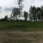
- Tent Sites
Features
For Campers
- Pets
- Fires

 Legend
Storm Damaged site
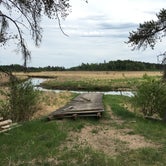
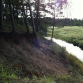
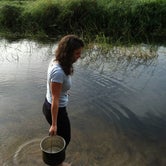
This used to be a great joint canoe landing and campsite on the Mississippi Headwaters state Water Trail, until a major windstorm came through and severely damaged the site. A whole grove of tall pines has now come down in what may have been a tornado, or at least a wall of straight line winds that affected the campsite and some of the surrounding area. The state DNR forestry crews have done some minimal clean-up, but the site is really in disrepair. There is still tenting space, but damaged fire grates have been removed and there are no picnic tables. There is still a canoe landing, but the dock is damaged and needs to be repaired. This is still a reasonable location to launch a canoe, but probably not desirable for camping, unfortunately. Fox Trap or High Cliffs further downstream, or the new Brownie site upstream, would be preferable for camping.
- (6) View All
 Legend
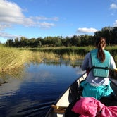
A great overnight stop for canoe/kayak trips
It is true that you can reach this campground by road, but it's an even greater experience if you access it by canoe/kayak via the Mississippi River. There are plenty of access locations to carry-in/carry-out (see map: http://files.dnr.state.mn.us/maps/state_forests/sft00034.pdf). Make sure to know what the riverbank near the campground looks like though, or you might paddle past it. (See photo).
There are fire pits at the campground, but no other facilities, given the remoteness of the location. So bring your own water and "toilet supplies."
Its a beautiful location, and usually a private experience - we've always been the only camping party at the campground.
- (6) View All
Location
Bear Den Landing Canoe Camp is located in Minnesota
Directions
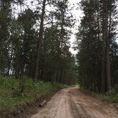
Bear Den Landing is easily accessible by road. An access road named Bear Den Canoe Landing heads east off of Beltrami County Highway 5 a bit north of the Mississippi River. After traveling east for a while, you will come to a fork in the road. Veer to the right. The road travels along high ground that has large swampy areas on both sides creating a peninsula. This land is actually a glacial moraine, a ridge of earth that was pushed up by a glacier during the last ice age. (Source: http://www.johnweeks.com/river_mississippi/pages01/bearden.html)
Coordinates
47.424021007229356 N
95.10422034032456 W