


Free Camping Collection
Established Camping
Albert Pike Recreation Area
About
National Forest
Ouachita National Forest
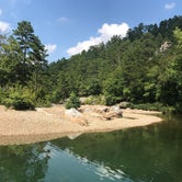
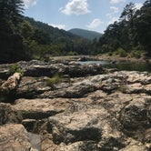
Nestled in the forested splendor of the rugged Ouachita Mountains, this recreation area is located in the southern portion of the national forest. Visitors are invited to hike the nature trail or experience the excitement of a canoe trip on the Little Missouri River.
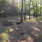
Day use/swimming only.
Access
- Walk-InPark in a lot, walk to your site.
- Hike-InBackcountry sites.
Stay Connected
- WiFiUnknown
- VerizonUnknown
- AT&TUnknown
- T-MobileUnknown
Site Types
- Tent Sites
- Standard (Tent/RV)
- Group
Features
For Campers
- Trash
- Picnic Table
- Drinking Water
- Toilets
- Alcohol
- Pets
- Fires
For Vehicles
- Pull-Through Sites

 Legend
Albert Pike Recreation Area - Day Use Only
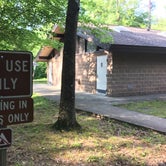
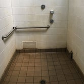
The Albert Pike Recreation Area is now for Day Use Only. As a result of flooding and potential flooding the former campground is now a day use area with parking spaces, picnic tables, water faucets and restrooms with toilets, sinks and showers.
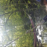
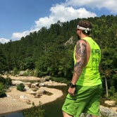
The main attraction of this area is the easy access to the Little Missouri River and the hiking trails along the Eagle Rock Loop. The river and the hiking trails are beautiful. If you need supplies, the town of De Queen has a number of stores, restaurants, gas stations and services available. The small town of Langley has a convenience store/gas station.
Depending on the time of year the mosquitos and black flies can be pervasive. The facilities are showing their age and some wear. On the weekend this area gets a high number of visitors, so it is best to arrive early in the day.
- (11) View All

 Traveler
One of the best
I love love this whole area, so sad you can't camp here any more. Tons of great spots nearby though, along the creeks. Alberta pike is overgrown but still beautiful, and quiet!
 Traveler
Winding Stairs Primitive Camping
this campground is closed due to a flood in 2010 in which multiple people were killed. But go here and go up the mountain on Forest Road 106, 2.1 miles and on your left will be Winding Stairs trailhead. hike this for some of the most beautiful scenery to offer. go about 2.3 miles in once you cross the river twice look for a small trail that leads to the ultimate camping spot. huge rock facing behind it and small path leads straight to some of the most clear blue swimming holes and beautiful rock facings that you will see anywhere in Arkansas. you will thank me, I promise!
- (5) View All
Location
Albert Pike Recreation Area is located in Arkansas
Directions
From Hot Springs take Highway 70 west 36 miles through Glenwood to Salem. Turn west on Highway 84 and go 13 miles to Langley. At Langley turn north on Highway 369 and go 6 miles to the recreation area.
Coordinates
34.37476452 N
93.87765655 W