


Established Camping
Doris Campground
About
Fish and Wildlife Service
Wichita Mountains Wildlife Refuge
Overview
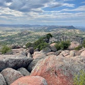
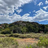
Worn by time and nature, the Wichita Mountains loom large above the prairie in southwest Oklahoma___a lasting refuge for wildlife. Situated just outside the Lawton/Ft. Sill area, Wichita Mountains Wildlife Refuge preserves approximately 60,000 acres of mixed grass prairie, ancient granite mountains, and fresh water lakes and streams for the benefit of wildlife and the American people. Best known for its roaming herds of bison, longhorn, and Rocky Mountain elk, Wichita Mountains also offers quality opportunities for wildlife dependent recreation including fishing, bird watching, wildlife photography, hiking, camping, and kayaking. __
Recreation
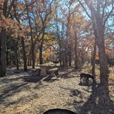
Doris Campground is a recreational hub for visitors to the Wichita Mountains. Situated along the shoreline of Quanah Parker Lake, it___s a stone___s throw away from quality fishing, canoeing, kayaking, and hiking. Campers can toss a line in the water or start up the Little Baldly trail for a picturesque hike. The Visitor Center, additional trails, and notable features like Mt. Scott are just a few miles down the road.__
Facilities
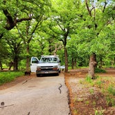
Doris Campground contains 3 group camping sites, 23 single family electric sites, 47 single family non-electric sites, and 20 semi-primitive, walk-in tent sites. Most campsites are sizeable enough for RVs and trailer. Each campsite is equipped with a picnic table, fire ring, and grill. Roads are paved. Flush toilets and showers are provided within easy walking distance in a centrally located shower/restroom complex. The group campsites and Loops A and D have chemical or vault toilets only, and no water. Water is available via hydrants throughout the campground. A dump station is provided for RVs and trailers.
Natural Features
Explore ancient granite mountains. Find yourself in a cedar forest. Dare to discover wide open spaces and fresh water lakes meant to support wildlife like the American bison and Rocky Mountain elk. Fish. Hike. Photograph. Immerse yourself in the wild.
Nearby Attractions
Wichita Mountains Wildlife Refuge encompasses roughly 60,000 acres. Doris Campground is centrally located allowing visitors opportunities to explore all areas of the refuge with a short drive. Head up Mount Scott or hang out at Prairie Dog Town. Bring your fishing pole, a set of binoculars, or your camera. The possibilities are endless.
Access
- Drive-InPark next to your site
- Walk-InPark in a lot, walk to your site.
- Hike-InBackcountry sites.
Stay Connected
- WiFiUnknown
- VerizonUnknown
- AT&TAvailable
- T-MobileUnknown
Site Types
- Tent Sites
- RV Sites
- Standard (Tent/RV)
- Group
- Tent Cabin
Features
For Campers
- Trash
- Firewood Available
- Phone Service
- Drinking Water
- Electric Hookups
- Toilets
- Pets
- Fires
For Vehicles
- Sanitary Dump
- Water Hookups

 Legend
Lovely spot
Great spot to see some wild life and check out the Witicha mountains.


- (11) View All

 Ranger
Absolutely beautiful!
Doris is in the middle of Wichita Mountain Wildlife Refuge, there is zero cell phone service but we got our Starlink to work perfectly. We stayed in 40c which had no hookups but was an enormous site with lots of privacy. Fairly level site, concrete table, huge fire pit and grill. Spots are very well maintained and this site backs up to Lake Quanah Parker. Little Baldy trail can be hiked directly from the campground. New shower and bathroom house.
100% will be back. Fantastic educational visitors center. You MUST drive up Mt Scott but it’s scary. Wonderful short hikes.
Free roaming bison, longhorns, wild Turkey, etc.


- (12) View All
 Legend
Good Experience in Campervan
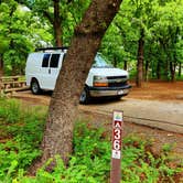
Camped in site 36, loop C, mid-May. Large campsite; lots of trees. Short path behind site leafs to Quanah Parker Lake. No connections. Water pump nearby; water was good quality. Restroom/shower house located at beginning of loop. Other restrooms were closed for renovation. The restroom/shower house is old & needs updating. Campsite was clean. Firewood available near campground entrance. Excellent hiking opportunities nearby. Separation between sites in this loop is good but little privacy. Campground host was friendly & helpful. Enjoyed staying in this old campground & exploring the refuge. Little to no AT&T and T-Mobile service.

- (9) View All
Location
Doris Campground is located in Oklahoma
Directions
From I-44 take Highway 49 (exit 45). Go west 7 miles to the Refuge gate or 14 miles to the Visitor Center. If coming from Highway 62, take Highway 115 (Cache exit) north to the Refuge Gate.__
Address
127 NW Camp Doris Road
Indiahoma, OK 73552
Coordinates
34.719333 N
98.64953 W