


Dispersed Camping
Manzanita Mountains Recreation Zone
About
USDA Forest Service
All recreation areas and trailheads south of Interstate 40 within the Sandia Ranger District. Please refer to the Manzanita Mountains Trail System map to plan your course. Cell phone coverage is not guaranteed It is the recreationist’s responsibility to know which trails are designated for motorized vehicles and to follow the guidelines. This is a multi-use area. Trail(s) open for the following uses: Hiking, Mountain Biking, Horseback Riding and OHV use. Area Trailheads: Lower Pine Trailhead Chamisoso Trailhead Coyote Trailhead Tunnel Canyon Trailhead Otero Canyon Trailhead Pine Flat Trailhead Cedro Trailhead Oak Flat Trailhead Area Picnicking: Pine Flat Group Picnic Area Oak, Yucca and Locust Picnic Group Areas Area Camping: Cedro Peak Camping Area
Access
- Drive-InPark next to your site
- Walk-InPark in a lot, walk to your site.
Stay Connected
- WiFiAvailable
- VerizonAvailable
- AT&TUnknown
- T-MobileUnknown
Site Types
- Dispersed
Features
For Campers
- Phone Service
- Alcohol
 Guide
GuideNov
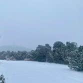
Really nice spot to stop for a few days. The road is doable, rough in a couple of spots. They’re doing some clearing up there. Very quiet, will be back again.
- (6) View All

 Ranger
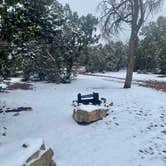
Great boondocking near ABQ
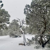
A favorite place to stop near ABQ. Lots of dispersed sites to choose from. Some roads are rough, I suggest scouting first if you’re hauling a load. It was easy to navigate in a camper van. Stayed by myself, felt safe. Surrounded by amazing views and trees! It’s a relatively clean area. No amenities or services; pack it in, pack it out. Decent cell service at the time.
Location
Manzanita Mountains Recreation Zone is located in New Mexico
Directions
From the west (Albuquerque), drive East on I-40 and exit at Exit 175. At the bottom of the ramp there is a traffic light. Continue straight through the light on NM 337. The Manzanita Trail System is along this corridor.
Coordinates
35.07399365 N
106.38671236 W