


Established Camping
Cochiti Recreation Area
About
US Army Corps of Engineers
Cochiti Lake
Overview
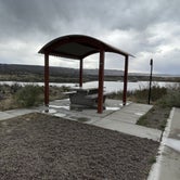
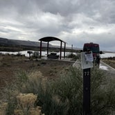
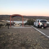
Cochiti Recreation Area is located in Sandoval County, New Mexico, within the boundaries of the Pueblo de Cochiti Indian Reservation. The lake offers two public recreation areas: Cochiti on the west side of the lake and Tetilla Peak on the east side. Both sides offer spectacular scenic views of the water and surrounding mountains. The Cochiti Dam is one of the ten largest earth-fill dams in the United States, and also one of the largest in the world. The lake derives its name from the Indian Pueblo on the Cochiti Reservation.
Recreation
Our quiet lake is an ideal location for all paddle, wind surfing, and sailing craft. The lake is also a popular fishing spot for species such as bass, crappie, walleye, pike, catfish, sunfish and trout. Cochiti Recreation Area has a popular, family friendly, swim beach Day Use area for public enjoyment. It is a fee area, $5 per vehicle, but the cost is covered by the campsite fee for visitors staying in the campground. Additionally, the Cochiti picnic area has 21 covered picnic sites with a large group site that can be reserved by calling the main office. Cochiti Day Use Areas are open from April 15th to October 15th.
Facilities
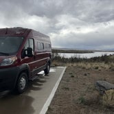
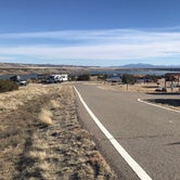
The campground consists of four loops. Juniper Loop campsites have electric hookups and some have water. Elk Run and Ringtail Loops are non-electric and have community water spigots. All sites in Buffalo Grove Loop have water and electric hookups. The Cochiti boat ramp is open year-round and is accessible by a paved road. The ramp has four concrete lanes for loading and unloading.
Natural Features
Cochiti Lake sits at 5,343ft in elevation and is nestled in the foothills of the Jemez Mountains. Our high desert environment is dominated by juniper, pinon trees, and mixed grasslands. There are many opportunities for wildlife viewing. Four osprey nesting platforms have been erected around the lake to provide nesting sites, as well as viewing opportunities. On the east side of the lake, deer, coyote, river otters, rabbits, beavers, and the occasional bear are often sighted.
Nearby Attractions
Cochiti Lake is five miles from Tent Rocks National Monument, which has fascinating geological formations.
Access
- Drive-InPark next to your site
- Walk-InPark in a lot, walk to your site.
- Boat-InSites accessible by watercraft.
Stay Connected
- WiFiGood
- VerizonGood
- AT&TFair
- T-MobileGood
Site Types
- Tent Sites
- RV Sites
- Standard (Tent/RV)
Features
For Campers
- Market
- Trash
- Picnic Table
- Phone Service
- WiFi
- Drinking Water
- Electric Hookups
- Toilets
- Pets
For Vehicles
- Sanitary Dump
- Water Hookups
- Pull-Through Sites
- Big Rig Friendly

 Legend
Another great CoE campground!
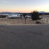
General: 80 campsites in four loops: Juniper (1-34), Elk Run (35-50), Buffalo Grove (51-66) and Ringtail Cat (67-80).
Site Quality: Driveways were paved and most had a concrete pad, and all sites appeared to be level. IMO, the best sites are in the Ringtail Cat loop for views (but there are no hookups). Buffalo Grove has electric and water hookups, as well as light posts. Sites 51, 53, 57, and 59 have the best views. Sites in Elk Run have light posts but no hookups or views. IMO, the sites in Juniper are the least desirable: yes they have electric hookups, but they are older, overgrown, and have no views. Each site has a picnic table (some are covered), a BBQ grill, and a lantern hook (if no light post).
Bath/Shower house: The one in Ringtail Cat loop was very clean. I did not use the shower but certainly would.
Activities: This was on our route for a one-night stay, and we were there out of season so did not explore options but there is a boat ramp. Not sure about other in-season activities. For $6 (with senior pass), for a non-electric site, this campground was an incredible value.
- (17) View All
 Scout
ScoutSmall and quiet
The campground is inside the Cochiti Pueblo Nation. Nice views of mountains and pastel sunrises and sunset. Great place to catch-up on online business.
 Guide
GuideClean and comfortable
About half of the Cochiti campground has sites with electricity and water. All sites have paved driveways, canopies, and charcoal grills. The entire campground is on a hill overlooking Cochiti Lake. Buffalo Grove sites 51 and 53 have a clear view over the lake. The Cochiti campground is about a 22 minutes drive to the center of Santa Fe. The only downside to the campground is that there are no trees and it can be windy or very sunny. The bathrooms were good with flush toilets, hot water in the sink, and free hot showers.
Location
Cochiti Recreation Area is located in New Mexico
Directions
From Albuquerque, New Mexico, take Interstate 25 north to exit 259. Turn west on State Route 22 and proceed through Pena Blanca to the park office and recreation area.
Address
82 DAM CREST RD
Pena blanca, NM 87041
Coordinates
35.6416667 N
106.325 W