


Free Camping Collection
Established Camping
Pharsalia Y Pond

About
State Park
The primary purposes of Pharsalia Wildlife Management Area (WMA) are for wildlife management, wildlife habitat management, and wildlife-dependent recreation. This WMA is 4,689 acres in size and is located in the northwest portion of Chenango County, approximately 10 miles southwest of Sherburne. Pharsalia generally has flat or gently sloping terrain.
In 1926 Pharsalia became the first State Game Refuge purchased with Conservation Fund monies. Thousands of trees and shrubs were planted for reforestation and wildlife purposes. A 200-man Civilian Conservation Corp camp accomplished much of the work and also constructed several small ponds for waterfowl use.
Reservation Info
Ordinarily there is no dispersed camping allowed in a WMA, even though it is allowed in the surrounding state forest. However, there are a few designated campsites within the WMA at which camping is allowed but ONLY with a permit from the regional DEC office. Permits must be obtained whether this site is used as a destination campsite, or as an overnight site for through hikers on the Finger Lakes Trail. To obtain a permit, contact: DEC Region 7 Cortland Office (M-F, 8:30AM - 4:45PM), (607) 753-3095; Info.R7@dec.ny.gov
Access
- Hike-InBackcountry sites.
Stay Connected
- WiFiUnknown
- VerizonUnknown
- AT&TUnknown
- T-MobileUnknown
Site Types
- Tent Sites
Features
For Campers
- Reservable
- Pets
- Fires

 Legend
Pharsalia Y Pond primitive campsite
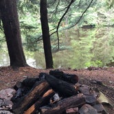
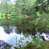
This campsite is a hike in stop on the Finger Lakes Trail, but can also be accessed by a short walk-in from Elmer Jackson Rd, or by paddling in from the parking area in the west side of the pond. The pond is deep and clear and stocked with brook trout, and the campsite on the east side of the pond is in an idyllic setting with good camping, fishing (canoe or kayak only), and day hikes on the Finger Lakes Trail. You can also walk or drive along various state forest riads to several other pinds in the Wildlife Management area for good birdwatching. From the south end if the pond is a cascade into a gorge which is the beginnings if Canasawacta Creek, which eventually flows to Norwich and the Chenango River.
This is a primitive canpsite, no shelter or latrine but there are several fire rings and good tent sites as well as a gentle water access right on the shore. This would be a nice family friendly weekend destination, as well a a great stop fir through hikers. Previous campers have left the site in great shape.
Camping in this DEC Wildlife Management Area campsite is limited, and requires a permit. Visit the regional DEC office at 1285 Fisher Ave., Cortland NY or call 607-753-3095, or email at Info.R7@dec.ny.gov ; allow one week for permit to be processed.
More info about the WMA can be found here: http://www.dec.ny.gov/outdoor/63889.html or http://www.dec.ny.gov/outdoor/70693.html
An interactive map for hiking in the area can be found here: https://fltconference.org/trails/P/TrailConditionMaps/Interactive/Seg_Cat.html?Vifw#"
For more info and local area map, see page 15 and map E04 in the Finger Lakes Trail East passport guide:
http://www.fltconference.org/trail/files/3814/0154/4940/Passport_East_View.pdf
- (9) View All
Location
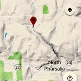
Pharsalia Y Pond is located in New York
Directions
New York Route 23 borders part of the west and south sides of the WMA and provides access to a system of town and maintenance roads traversing the WMA. Head west out of Norwich on Route 23 to the town of Pharsalia. The WMA is on your right. All Google links leave DEC website. • Elmer Jackson Road (42.6268997°N,-75.7157974°W) • John Smith Road (42.6180992°N,-75.7303009°W) • John Smith Road (42.6213989°N,-75.7300034°W) • John Smith Road (42.6234016°N,-75.729599°W) • Elmer Jackson Road (42.6300011°N,-75.7151031°W) • Cole Hill Road (42.6391983°N,-75.6774979°W) • Johnson Street (42.6399002°N,-75.6901016°W) • Johnson Street (42.6385994°N,-75.694603°W) • Mud Lane Road to Bear Wallow (42.6450996°N,-75.6968994°W) • Johnson Street (42.6313019°N,-75.7279968°W) • Grover Brown Road (42.6181984°N,-75.6949005°W)
Coordinates
42.6257259 N
75.7148254 W