


Established Camping
Trace Branch - Buckhorn Lake
About
US Army Corps of Engineers
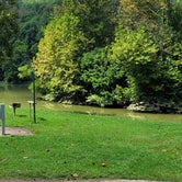
Buckhorn Lake
Overview
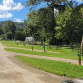
The Trace Branch Campground, located on Buckhorn Lake, is a great launchpad for outdoor activities in Kentucky's lush Cumberland Plateau. The facility features plenty of shade and open grassy areas for spreading out and enjoying the landscape of the Appalachian Mountain Range.
Recreation
Buckhorn lake offers ideal conditions for anglers including seclusion from fishing pressure and boat traffic, producing some of the best muskie fishing in the area. With comfortable water temperatures,swimming and water skiing are popular in summer months and hikers are encouraged to take advantage of the area's many miles of trails.
Facilities
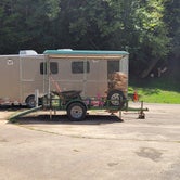
Trace Branch Campground boasts mostly waterfront campsites with electric and water hookups. Amenities include a shower house, playground, horseshoe pits, and a convenient fishing area.
Natural Features
Buckhorn Lake is situated in the Cumberland Plateau of eastern Kentucky. The rugged plateau landscape is deeply traversed by a series of narrow, winding valleys separated by steep watersheds with branching streams. The Kentucky River feeds the lake, originating in the southeast of the state and flowing generally northwestward.
Nearby Attractions
Nearby destinations include the Lilley Cornett Woods, Daniel Boone National Forest, Natural Bridge State Resort Park and the Red River Gorge Geological Area.
Access
- Drive-InPark next to your site
Stay Connected
- WiFiUnknown
- VerizonUnknown
- AT&TUnknown
- T-MobileUnknown
Site Types
- Tent Sites
- RV Sites
- Standard (Tent/RV)
- Dispersed
- Group
- Tent Cabin
Features
For Campers
- Trash
- Picnic Table
- Firewood Available
- Drinking Water
- Electric Hookups
- Alcohol
- Pets
- Fires
For Vehicles
- Sanitary Dump
- Sewer Hookups
- Water Hookups

 Guide
GuideQuiet, remote, water access, playground
This campground is a hidden gem. It's in the hills, far off the beaten path, and half of the campsites are right on the water. In addition to campsites, the park has picnic areas, bathrooms, showers, a playground, and a boat ramp.
Campsites have hookups for electric and water, with a dump site nearby. There are also picnic tables and fire rings, with firewood available to purchase.
Access to the camp may be tough for larger rigs as theres a few miles of windy, one-lane roads with switchbacks, drop-offs, and the occasional washout.
There is also no cell service here, so be prepared to unplug and unwind. =)
This area looks to be prone to flooding in the the spring months when the snows thaw so time your visit accordingly.
The men's bathrooms don't appear to have been cleaned in awhile and weren't cleaned during my week there. Only half of the toilets would flush.
It's a popular place for the locals with kids on the weekends so if you're looking for peace and quiet it's best to visit during the week. Great place to let the kids run wild and make friends though.

 Scout
ScoutTropical paradise
Not what I figured it would be but considering it was alright
 Guide
GuideComfy and great for fishing and boating
I stayed here for two night and enjoyed my time. RV spots are a little close to your neighbor but it was quiet and peaceful. This is a great spot if you don't mind not having a network connection or Wi-Fi. Spot comes with an electrical hook-up, water, fire pit, and a picnic table. There are also bathrooms and showers and outdoor trash cans to throw away your garbage. I highly recommend this campsite. I had a great time.
- (7) View All
Location
Trace Branch - Buckhorn Lake is located in Kentucky
Directions
From Lexington, KY, take I-75 south 83 miles to London. Take exit 41 or 38 to Daniel Boone Parkway east and continue 44 miles to Hyden Spur. Exit towards Tim Couch Pass and turn left towards Thousandsticks onto Bull Creek Road. Go 2.5 miles to KY Highway 257, then head north about 9 miles to the Confluence bridge. Turn right and cross the bridge, then take a left on Mosley Bend Road. Continue 2 miles to Trace Branch Campground on your left.
Address
804 BUCKHORN DAM ROAD
Buckhorn, KY 41721-8808
Coordinates
37.2416667 N
83.3727778 W