Campground photo 1
Campground photo 2
Campground photo 3

Places to Camp near Barbourville, KY

513 Reviews

The Dyrt is here to help plan your best camping near Barbourville. Camping, hiking, biking: however you want to spend your days near Barbourville, you'll find great campgrounds with The Dyrt. You're sure to find the perfect campground for your Barbourville camping trip.

Best Camping Sites Near Barbourville, KY (106)

  1. Camper-submitted photo from Cumberland Falls State Resort Park
  2. Camper-submitted photo from Indian Mountain State Park Campground — Indian Mountain State Park
  3. Camper-submitted photo from Levi Jackson Wilderness State Park Campground
  4. Camper-submitted photo from Corbin - Laurel Lake KOA

    4.

    Corbin - Laurel Lake KOA

    10 Reviews
    35 Photos
    34 Saves
    Corbin, Kentucky
    • Pets
    • Fires
    • Electric Hookups
    • Phone Service
    • Reservable
    • ADA Access
  5. Camper-submitted photo from Holly Bay

    5.

    Holly Bay

    13 Reviews
    62 Photos
    128 Saves
    Keavy, Kentucky

    Overview

    Holly Bay, located two miles north of the Laurel River Dam, sits on the west side of Laurel River Lake. Visitors enjoy the campground for its proximity to the water and beautifully forested location. Plus, Holly Bay is ideal for activities like power boating, canoeing and fishing. The forest was named after Daniel Boone, a famous frontiersman and explorer who settled in Kentucky in the late 18th century.

    Recreation

    Boating and water skiing are a big hit. A boat ramp and fish cleaning station are located a short distance from the campground. Hikers take pleasure in the 4.2-mile Sheltowee Trace Trail that leads from the campground to the dam.

    Facilities

    The campground offers single and double-family campsites, some of which have 20, 30 or 50-amp electric hookups. Some campsites overlook the lake.Flush toilets (one is accessible), two shower houses, drinking water and a dump station are provided. Firewood and ice are available for purchase. Educational programs are held during the summer. AmericanLL.com__

    Natural Features

    Most campsites are surrounded by a mixture of hardwood trees that provide picture-perfect colors in autumn. Laurel River Lake spans 5,600 acres of deep, clear water and 192 miles of cliff-lined shore. Bountiful hills from the Appalachian foothills create a backdrop for the lake area.

    contact_info

    For facility specific information, please call (606) 878-8134.

    Nearby Attractions

    Head to the Cumberland Falls Trail that begins at Cumberland Falls and ends at the mouth of the Laurel River. This trail is a 30-45 minute drive from the campground.

    • Pets
    • Fires
    • Electric Hookups
    • Phone Service
    • RVs
    • Tents

    $38 / night

  6. Camper-submitted photo from Wilderness Road State Park Campground

    6.

    Wilderness Road State Park Campground

    11 Reviews
    37 Photos
    63 Saves
    Shawanee, Tennessee

    Overview

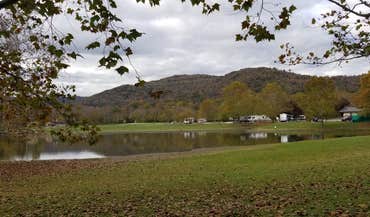
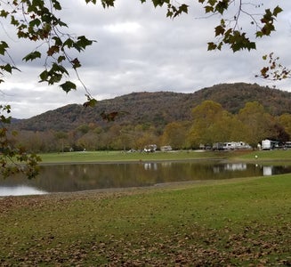
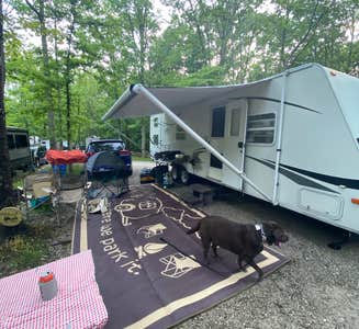
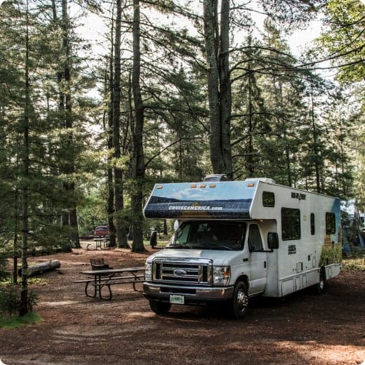
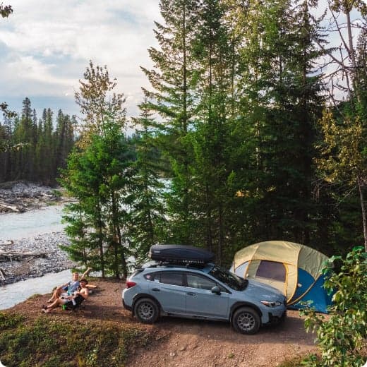
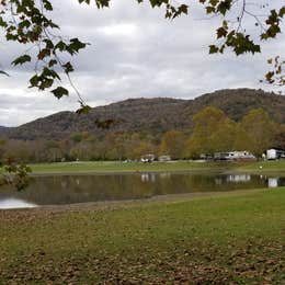
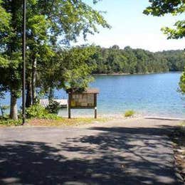
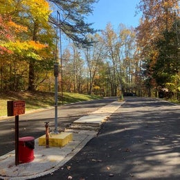
    Wilderness Road Campground is nestled in the lush forests of the Appalachian Mountains in Cumberland Gap National Historical Park , where Kentucky, Tennessee, and Virginia meet. You can access miles of forest and mountain trails directly from the campground.____ While in the park, drive up to the Pinnacle for a breathtaking view of the mountains or check out Civil War earthworks. Hike to the pale cliffs of White Rocks, the gaping mouth of Sand Cave, or the historic Hensley Settlement to see how mountain folk once lived. Stand in 3 states at the same time or immerse yourself in thousands of acres of proposed wilderness. Walk a path once traveled by the bison, Native American, longhunter, and pioneer. Stand in the narrow mountain gap where Daniel Boone stood and where thousands of people risked everything to reach and settle what would become America.____ Wilderness Road Campground includes 154 wooded sites open to tents, trailers, and RV campers. Electrical hookups (20-, 30-, or 50-amp) are available at 41 sites. Group sites are also available. The campground is open year-round, with limited campsites open during the winter season (mid-November to mid-March).__

    Recreation

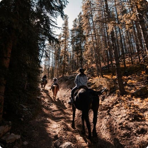
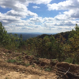
    Over 85 miles of trails offer plenty of opportunities for Hiking and Backpacking adventures in the great outdoors. You can take an easy 1/4-mile stroll or go on a challenging 10-mile hike in the backcountry, the choice is yours. Several trails meander through over 14,000 acres of proposed wilderness.__ Backcountry Camping is allowed at 5 designated sites in the park with a permit. Experience the quiet beauty of the mountains and wilderness as you camp under the stars. Permits are free of charge and can be obtained at the park visitor center.__ Picnicking at one of several picnic areas in the park is a popular activity. Whether you are looking for a quiet lunch while enjoying nature or having a big family get-together in the great outdoors, we have limitless options. You can also reserve a picnic shelter for exclusive day use for a fee. Stop by the park visitor center to reserve a picnic shelter up to 3 months in advance.__ Horseback Riding is permitted on the 17-mile Ridge Trail, which extends from the Pinnacle to White Rocks.__ Guided Tours, Hikes, and Programs range from Pioneer and Civil War Living History demonstrations to guided tours of Gap Cave (formerly known as Cudjo's Cave), and from guided tours of the historic Hensley Settlement to Campfire Programs. Programs offered vary seasonally. Fees are charged for Gap Cave and Hensley Settlement tours. Stop by the park visitor center for program tickets and information.__

    Facilities

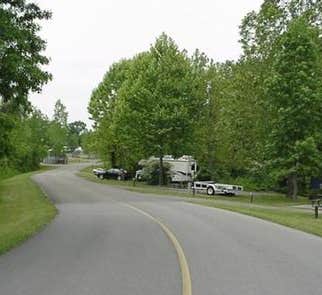
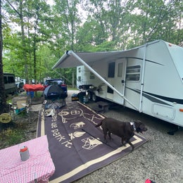
    Wilderness Road Campground is located about 3 miles from the park visitor center, off Highway 58 in Virginia. 154 woodland sites welcome tents, trailers, and RV campers. 41 sites with 20-,30-, and 50-amp electric hook-ups are available in loops B and C. Hot showers and potable water are located in the comfort stations. A dump station, for campground reservation holders only, is located near the entrance station. Sites are accessed through paved loop roads. Most sites require backing in with the exception of one pull-through site.__ Cumberland Gap National Historical Park Visitor Center is located on U.S. Highway 25E just south of Middlesboro, KY. Restroom facilities are located on the outside of the building. The visitor center is fully accessible with designated parking and an elevator. The park visitor center is open daily from 9:00 A.M. until 4:00 P.M. Eastern time. It is closed on December 25.__ America's National Parks Store offers books, souvenirs, games, postcards, and other items related to the park and its many stories. Your purchase from our national park stores helps to provide inspiring educational experiences to millions of park visitors each year.__ Daniel Boone Parking and Exhibit Area is located just off Highway 58 near the town of Cumberland Gap, Tennessee. Wilderness Road Trailhead is located here. An outdoor pavilion features the sights and sounds of early travelers and pioneers. Restroom facilities are available here.

    Natural Features

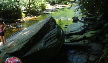
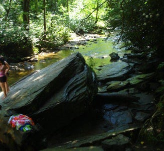
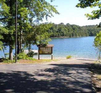
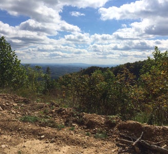
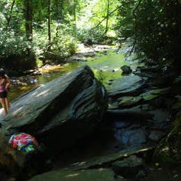
    Cumberland Gap National Historical Park protects 24,000 acres of Appalachian Mountain habitat stretching across Kentucky, Tennessee, and Virginia. Walk the trails that Daniel Boone and thirty axemen blazed to open the first great gateway to the West. Plan your visit today and experience the natural, historical, and cultural beauty of the park. Cumberland Gap, carved out over aeons by wind and water, forms a V-shaped notch or gap in the formidable wall of the Appalachian Mountains. This natural low point made crossing over the mountains easier and less dangerous for bison and other animals, then later for Native Americans, and still later for European explorers and early pioneers. Stand right in the Gap where over 300,000 settlers crossed the mountains on their journey to the west.__ The cliffs of White Rocks rise 500 feet above the surrounding wooded slopes at the east end of the park. Anyone up for a challenging hike to the top of the mountain will be rewarded with a breath-taking, 360-degree view of the surrounding area.__ A natural scenic area in Kentucky, Sand Cave is a half-domed chamber that is 250 feet across in front (open). The floor slopes from back to front and is 1.25 acres of fine, colorful sand. Relax and enjoy nature in this magical, enormous natural feature. Skylight Cave lies at the end of a steep, 1.9-mile hike in Ewing, Virginia. Start out on Lewis Hollow Trail, from the picnic area near Wilderness Road Campground. Hike through lush rhododendrons and along a river until you reach the cave. Gap Cave was first found by European explorers in 1750, when Dr. Thomas Walker found and named it Gap Cave. Located in Lee County, Virginia, the cave is 18.5 miles long and accessible only by guided tour.__ East of the Gap, the Cumberland Mountain Range includes 15,470 acres of roadless habitat extending 15 miles along the Cumberland and Brush Mountains. The ridge of Cumberland Mountain forms the Kentucky-Virginia state line. Both Cumberland and Brush Mountains are exceedingly steep and rugged with high cliffs in many areas. Chimney Rock is a geological formation shaped like a pillar. Located at the Pinnacle Overlook, this unique rock formation could have taken 535 million years to form. Gap Creek is a small cascade of water flowing out of Gap Cave. This peaceful natural feature is a great spot for capturing pictures and videos. Yellow Creek runs along the park boundary behind New Bartlett Park and Old Barlett Park picnic shelters. Enjoy time playing in the creek, or simply listen to the flow of the water. More than 14,000 acres of the park are managed as Wilderness, where visitors can experience the backcountry and nature in the purest way.

    contact_info

    For facility specific information, please call (606) 248-2817.

    Nearby Attractions

    Nearby National Park Service Areas: Big South Fork National River & Recreational Area 90mi Andrew Johnson National Historic Site 80mi Great Smoky Mountains National Park 120mi Mammoth Cave National Park 225mi Other Local Attractions: Kentucky Coal Mining Museum (606) 848-1530, 45mi Abraham Lincoln Museum (423) 869- 6235, 3mi Pine Mountain State Resort Park (276) 445-3065, 10mi Wilderness Road State Park (276) 445-3065, 10mi Regional Tourism Information: Southern & Eastern KY Tourism Development Association__ Kentucky Appalachians__ Visit Eastern Kentucky__ Bell County (KY) Historical Society__ Bell County (KY) Tourism__ Tennessee Regions: Middle East__ Claiborne County (TN) Tourism__ Virginia Regions: Heart of Appalachia__ Visit Southwest Virginia__

    Charges & Cancellations

    Rules and Reservation Policies__

    • Pets
    • Fires
    • Electric Hookups
    • Phone Service
    • RVs
    • Tents

    $24 / night

  7. Camper-submitted photo from Pine Mountain State Resort Park

    7.

    Pine Mountain State Resort Park

    7 Reviews
    21 Photos
    23 Saves
    Pineville, Kentucky

    Pine Mountain is one of Kentuckys most scenic parks located in the heart of the Kentucky Ridge State Forest and features some of the most beautiful mountain scenery in the state. The Herndon J. Evans lodge is a very modern resort with a hint of a historic past. The passage of time has not diminished the beauty and workmanship of the original sandstone and chestnut log construction. Pine Mountain was the first state park being established in 1924 and having most of the park constructed by the Civilian Conservation Corps - CCC. The park has over 1600 acres with over half being dedicated to a state nature preserve. The Herdon J. Evans Lodge has 30 rooms, and there are 11 two bedroom cottages, 9 one bedroom log cabins with dining facilities, 14 hiking trails and home of the 18-hole Wasioto Winds Golf Course. The park also has meeting and banquet space, along with an outdoor amphitheater.

    • Pets
    • Fires
    • Electric Hookups
    • Phone Service
    • Reservable
    • RVs
  8. Camper-submitted photo from Blue Heron Campground — Big South Fork National River and Recreation Area

    8.

    Blue Heron Campground — Big South Fork National River and Recreation Area

    21 Reviews
    126 Photos
    31 Saves
    Stearns, Kentucky

    Overview

    Blue Heron Campground is a rustic and spacious campground, situated on the Kentucky side of The Big South Fork National River and Recreation Area--a vast and scenic expanse of land that offers visitors countless recreational activities.

    Recreation

    Numerous trails snake through the Recreation Area, offering mountain biking, hiking and horseback riding for visitors. The main river of the Big South Fork is also a short drive away, offering fishing opportunities.

    Facilities

    Blue Heron Campground combines the experience of traditional woods camping with the modern convenience of flush toilets, hot showers and electric hookups. Sites can accommodate both RV and tent camping. The campsites are spacious and provide picnic areas and plenty of shade.

    Natural Features

    The Big South Fork is located in north central Tennessee and southeastern Kentucky in some of the most rugged terrain of the Cumberland Plateau. The park encompasses approximately 125,000 acres of both rocky gorges and forested plateaus. Numerous pristine streams unite with the free-flowing Big South Fork of the Cumberland River. Over thousands of years, this ceaselessly moving water has carved the sandstone of the plateau into impressive cliffs, arches and chimneys that are found throughout the park.

    Nearby Attractions

    Just a few miles from the campground is Blue Heron Mine, also known as Mine 18, a historic abandoned mining town that has been rebuilt as an outdoor museum. Visitors can hear audio presentations from actual people who lived in the community in the 1950s. The Big South Fork Scenic Railway Depot is located about 9 miles away in the town of Stearns, which offers train rides and other educational opportunities for campers. More information can be found online at https://bsfsry.com. Additional attractions include the Daniel Boone National Forest and Cumberland Falls State Resort Park, offering additional recreation opportunities.

    • Pets
    • Fires
    • Electric Hookups
    • Phone Service
    • RVs
    • Tents

    $35 / night

  9. 9.

    Clayton Geneva Memorial Campground

    7 Reviews
    66 Photos
    41 Saves
    Williamsburg, Kentucky

    Thank you for considering Clayton Geneva memorial campground for your camping trip. Please read the entire description including our rules and regulations. Also be sure to view the site map. The gravel driveway to the sites is passable with any vehicle. If you choose to use our alternate parking there will be a hike to your site, appropriately 1/8 of a mile. I can’t stress enough that it is primitive camping, there is a restroom available at the top of the hill. We are inviting you to enjoy a peaceful, primitive camping experience on a spacious plot right on the sandy banks of the Cumberland River. We offer a tree canopy covered, serene spot that offers river swimming, fishing, enjoy a camp fire or just plain nothing but peace and quiet. Each site is equipt with a fire ring. The drive way to the primitive sites is a little lane that wraps around a mountain side that leads to the primitive sites. We do our best to keep up with it however due to the nature of weather, gravity and water it’s a constant chore. Your welcome to hike in to the sites, it’s not mandatory that you driver on down. If you feel comfortable by all means slowly drive directly to your site. If your not sure of the lane please hike to your site. Hikers, Horses and riders welcome, located a couple miles from Daniel Boone National Forrest, seemingly endless trails through some of the most beautiful country. Bring your canoe and kayaks. Located 16 miles from Cumberland Falls State Park. Located 11 miles from Sheltowee Trade Adventure Park. Located 11 miles from Kentucky Splash Water Park. Located 11 miles from Wal-Mart, restaurants and Pilot

    • Pets
    • Fires
    • Electric Hookups
    • Phone Service
    • Reservable
    • ADA Access

    $20 - $70 / night

  10. Camper-submitted photo from Bee Rock Rec Area

    10.

    Bee Rock Rec Area

    10 Reviews
    29 Photos
    35 Saves
    Laurel River Lake, Kentucky

    In March 2019 a record flood devastated the campground, boat ramp, and trails in this area. Bee Rock Campground will remain closed until recreation facilities are safely restored. View Bee Rock Closure Order. To find other campgrounds nearby, contact the London Ranger District at 606-864-4163, Monday-Friday 8 a.m. to 4:30 p.m. Campground facilities at nearby Laurel River Lake open on April 12.Bee Rock Campground, located on London Ranger District, has developed campsites on both sides of the Rockcastle River. The campground is a US Fee Area. The Laurel County side, with 9 sites, is open all year. The Pulaski County side, with 19 sites, is open from mid-April through mid-October. An overlook along Bee Rock Loop Trail provides a scenic view of the rocks and cliffs along Rockcastle River. Bee Rock Boat Rampprovides river access. The campground features Old Sublimity Bridge, a historic structure built by the Civilian Conservation Corp (CCC) in the late 1930s. The stone used in the abutments was quarried from the adjacent sandstone cliffs. The bridge has been restored for foot travel only. The name Bee Rock comes from a local legend which states that a large number of wild honeybees used to live in this area, using a hollow area under this cliff as their hive. Tired of the wild honeybees invading their hives, local beekeepers dynamited the rock, destroying the hive and causing honey to flow down the cliff into the Rockcastle River. Make this page look nicer by submitting photos of your visit to Bee Rock Campground. Learn more... Bee Rock Campground Map Campfires are permitted in fire rings only. Make sure fires are out before retiring at night or when leaving your campsite. Parking is available at campsites, boat ramp and overflow parking area. Restrooms are accessible vault toilets. Drinking water is available except during winter months. No climbing or rappelling from cliffs, arches or other rock formations at Bee Rock Overlook. Low lying areas are prone to flooding, so be alert for flooding when driving, camping or crossing streams in this area. Swift currents and undertows can make swimming and wading very hazardous. View Bee Rock Campground Guide & Map (pdf) Nearby Trails: Bee Rock Loop Trail #529 Rockcastle Narrows Trail #503 Rockcastle Connector Trail #401A Sheltowee Trace Section 25

    • Pets
    • Fires
    • Electric Hookups
    • Reservable
    • ADA Access
    • RVs

    $8 - $12 / night


Popular Camping Styles near Barbourville

Pet-friendly camping near Barbourville

Recent Reviews In Barbourville

513 Reviews of 106 Barbourville Campgrounds