Legend
No frills NPS campground with spacious sites, close to canyon views and
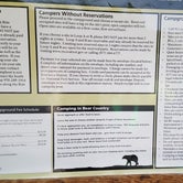
There are approximately 90 sites, split among 3 loops: - A: reservations (through recreation.gov)
B: reservations electric hookups
C: no reservations
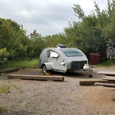
Loops A and B have many more back in/pull in and pull through sites than loop C has. See photos for sites. Most sites in loop C are roadside for the vehicle/RV with a few pull through and back in sites; the sites are spacious.
In June, all sites in A and B were booked. There was plenty of room in C early in the afternoon but it filled up by evening. A rainy Saturday led to a half full loop C that evening. Based on the activity every morning in loop C, it looks like most people spend only one night in that loop. The Reserved signs in loop A and B indicated people with reservations are more likely to stay a few nights.
If the campground fills up, there is dispersed camping just outside the park on the right (as you drive out). It looked like a area that could accommodate several campers without being on top of each other.
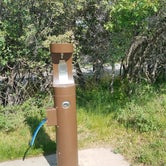
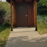
There is no water at the sites, but a potable water station is available. There are vault toilets in each loop...kinda smelly but that's what you get with a vault toilet!
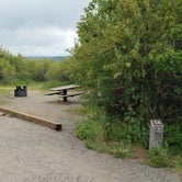
Each site has a picnic table, fire ring and bear-proof lockers. Due to fire danger, no fires are currently (June, 2018) allowed in the fire ring. The lockers are necessary if you don't want to store food in your locked car or RV. Mule deer are more of an issue than bears; they come right through the sites so I wouldn't leave anything out..for bears or deer. If you have a dog, there are very few areas where they are allowed at this time.
No generators are allowed in the campground. It's real camping!
Rim RockTrail and Uplands Trail (two mile roundtrip for each) lead to the visitor center from the campground. From the visitor center, the Oak Flat Loop is a 2 mile hike with some great views and a 400 foot drop in elevation (followed by a climb back to the visitor center). This "black" canyon is unique in terms of color and the shape and sheer steepness of the rocks.
If you want an adventure, there is a trail to the Gunnison River off Oak Flat Loop. It's a mile to the river from that point with about a 1,400 foot drop in elevation. The trail is not well marked and more difficult to find your way back. You need to get a permit at the visitor center for this area (and other areas within the canyon).
If you drive the South Rim Drive, there are plenty of overlooks along with some short walks (1/4 to 3/4 mile roundtrip). When the road ends, the Warner Point Trail is a 1.5 mile roundtrip.
East Portal Road (right turn just after entering the park) takes you to the Gunnison Diversion Dam and Crystal Dam, where the road ends. This will get you to the river and bottom of the canyon. There is another campground called East Portal with 15 sites with tent pads; some sites are walkin. Vehicles longer than 22 feet are prohibited on East Portal Road.